


Click Image to Enlarge
Minnesota Counties
There are eighty-seven Counties in Minnesota. On October 27, 1849 nine large Minnesota Counties were created. Among them were Benton, Dahkotah, Itasca, Ramsey, Mahkahta, Pembina, Wabashaw, Washington, and Wahnata. Of those Benton, Dakota, Itasca, Ramsey, Wabasha, and Washington still exist as their original name. With the creation of Kittson County on March 9, 1878, Pembina County no longer existed. When Minnesota was organized as a state, 57 of the present 87 Counties were established. The last county to be created was Lake of the Woods County in 1923Morrison County, Minnesota
Morrison County Education, Geography, and History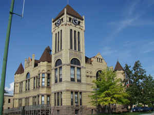
Morrison County is a county located in the state of Minnesota. Based on the 2010 census, the population was 33,198. Its county seat is Little Falls.
Etymology - Origin of Morrison County Name
Named for the brothers William and Allen Morrison. William Morrison, fur trader for American Fur Company, established trading posts from Grand Portage to the Lake of the Woods. Allen Morrison was a representative in the first territorial legislature.
Demographics:
County QuickFacts: CensusBureau Quick Facts
Morrison County History
First the Dakotah and then the Ojibwe Indians lived in the central Minnesota area around the Mississippi River.
French and English fur traders and voyageurs traveled through Minnesota from the 17th century to the 19th century. They used the river to
transport their goods and trade with the natives. The county was named for fur trading brothers, William and Allan Morrison.
Three prominent explorers lead expeditions along the river through the area that would be known as Morrison County in the 19th century.
Zebulon Montgomery Pike came through in 1805. Governor Lewis B. Cass led an expedition through the area in 1820. Joseph N. Nicollet, explorer
and scientist, had created the first accurate map of the area along the river in 1836.
Missionaries were some of the areas first European settlers. Methodist missionaries settled temporarily along the Little Elk River in 1838.
The Reverend Frederic and Elisabeth (Taylor) Ayer moved to the Belle Prairie area in 1849. They started a mission and school there for the
Ojibwe. Father Francis Xavier Pierz came to the area in 1852 and started many communities in central Minnesota, including Sobieski and Rich
Prairie (later renamed Pierz) in Morrison County.
The event that prodded further development of the county was the building of Fort Ripley. In order to construct this military outpost, a dam
and sawmill were erected in 1849 by the Little Falls Mill and Land Company. This company was formed by James Green, Allan Morrison, Henry M.
Rice, John Irvine, John Blair Smith Todd, and Napoleon Jackson Tecumseh Dana. Fort Ripley was built ostensibly to protect the Winnebago
Indians, who had been relocated by Henry Rice from Iowa to central Minnesota west of the Mississippi River, between the Crow Wing and Long
Prairie rivers. Rice hoped the Winnebago would act as a buffer between the warring Ojibwe and Dakotah Indians. His plan was unsuccessful and
the Winnebago were moved to the Blue Earth River in southern Minnesota in 1855.
Morrison County was created on February 25, 1856 (Organized in 1856) from Benton County. The county was named in honor of the brothers William
and Allen Morrison. William Morrison, fur trader for American Fur Company, established trading posts from Grand Portage to the Lake of the
Woods. Allen Morrison was a representative in the first territorial legislature. The County Seat is located in Little Falls
Little Falls, the county seat, sprung up when a second dam was built by the Little Falls Company (later called the Little Falls Manufacturing
Company). This dam washed out, as the first had done, and Little Falls entered a long period of economic depression and stagnation as far as
population growth. Bit by bit, Little Falls grew, until it was officially incorporated as a village in 1879.
Geography: Land and Water
As reported by the Census Bureau, the county has a total area of 1,153 square miles (2,990 km2), of which 1,125 square miles (2,910 km2) is land and 28 square miles (73 km2) (2.5%) is water.
Neighboring Counties
Bordering counties are as follows:
- Cass County (north)
- Crow Wing County (northeast)
- Mille Lacs County (east)
- Benton County (southeast)
- Stearns County (south)
- Todd County (west)
Education


Click Image to Enlarge
