


Click Image to Enlarge
Minnesota Counties
There are eighty-seven Counties in Minnesota. On October 27, 1849 nine large Minnesota Counties were created. Among them were Benton, Dahkotah, Itasca, Ramsey, Mahkahta, Pembina, Wabashaw, Washington, and Wahnata. Of those Benton, Dakota, Itasca, Ramsey, Wabasha, and Washington still exist as their original name. With the creation of Kittson County on March 9, 1878, Pembina County no longer existed. When Minnesota was organized as a state, 57 of the present 87 Counties were established. The last county to be created was Lake of the Woods County in 1923Nicollet County, Minnesota
Nicollet County Education, Geography, and History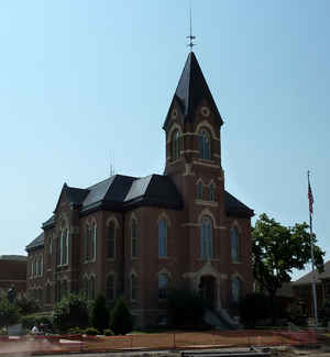
Nicollet County is a county located in the state of Minnesota. It was named for French geographer Joseph N. Nicollet. Based on the 2010 census, the population was 32,727. Its county seat is St. Peter.
Nicollet County is part of the Mankato-North Mankato, MN Metropolitan Statistical Area.
Etymology - Origin of Nicollet County Name
Named for Joseph Nicollet, geographer and explorer, who led expedition to Minnesota and parts of North and South Dakota.
Demographics:
County QuickFacts: CensusBureau Quick Facts
Nicollet County History
The current state of Minnesota along with Wisconsin, Illinois, and several other states was originally known as the Northwest Territory, often referred to today as the Old Northwest Territory in historical circles. Nicollet County was created in 1853 from previously unorganized territory and was named in honor of the noted French explorer, Joseph N. Nicollet.
In 1880 construction was started on the County Courthouse and it was completed in 1881. Over the years the courthouse has been subject to many renovations of the original structure. The original style was mixed Romanesque and Queen Anne styles of architecture and was designed by noted St. Paul architects of the day; Bassford and Stebbins.
Geography: Land and Water
As reported by the Census Bureau, the county has a total area of 467 square miles (1,210 km2), of which 448 square miles (1,160 km2) is land and 18 square miles (47 km2) (3.9%) is water.
Neighboring Counties
Bordering counties are as follows:
- Sibley County (north)
- Le Sueur County (east)
- Blue Earth County (southeast)
- Brown County (southwest)
- Renville County (northwest)
Education


Click Image to Enlarge
