


Click Image to Enlarge
Minnesota Counties
There are eighty-seven Counties in Minnesota. On October 27, 1849 nine large Minnesota Counties were created. Among them were Benton, Dahkotah, Itasca, Ramsey, Mahkahta, Pembina, Wabashaw, Washington, and Wahnata. Of those Benton, Dakota, Itasca, Ramsey, Wabasha, and Washington still exist as their original name. With the creation of Kittson County on March 9, 1878, Pembina County no longer existed. When Minnesota was organized as a state, 57 of the present 87 Counties were established. The last county to be created was Lake of the Woods County in 1923Pope County, Minnesota
Pope County Education, Geography, and History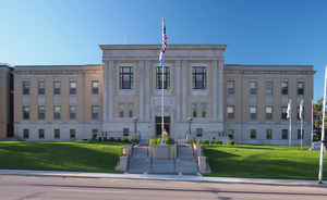
Pope County is a county located in the state of Minnesota. Based on the 2010 census, the population was 10,995. Its county seat is Glenwood. The county was formed in 1862 and organized in 1866.
Etymology - Origin of Pope County Name
Named for General John Pope, who explored sections of the Red, Crow Wing and Mississippi Rivers in 1849; based in St. Paul as commander of the Department of the Northwest during the Dakota War, 1863-64.
The preceding is excerpted from the Illustrated Album of Biography published by Alden, Ogle & Company, 1888.
General John Pope, born in Louisville, Kentucky, March 16, 1822, died in Sandusky, Ohio, September 23, 1892. He graduated
at West Point in 1842, and served as a lieutenant in the Mexican War. During the summer of 1849 he was a member of an exploring expedition
under the command of Major Samuel Woods which went from Fort Snelling up the Mississippi river and passed White Bear Lake (Minnewaska) in the
present Pope County to the Red River, and thence northward by a route at a considerable distance west of the river to Pembina. On the return,
in order to make a thorough examination of the Red River, Pope and a small number of the party embarked in canoes and ascended this river to
Ottertail Lake, made the portage to Leaf Lake, and thence descended the Leaf, Crow Wing and Mississippi Rivers. He wrote in his report: 'On
the 27th of September we arrived at Fort Snelling and completed a voyage of nearly 1,000 miles, never before made by anyone with a like
object.'?
At the time of this expedition, Pope was a captain. He was afterwards, in 1853 and 1859, commander of the expedition, making surveys for the
Pacific Railroad near the 32nd parallel. In the Civil War he was an energetic defender of the Union. Early in 1862 he was commissioned major
general of volunteers. September 6, 1862, shortly after the outbreak of the Sioux war in Minnesota, General Pope was appointed commander of
the Department of the Northwest with headquarters in St. Paul, and he continued in charge of the department until January, 1865. To his
efficient direction and cooperation was due, in a large degree, the success of Generals Sibley and Sully in their campaign against the Sioux.
Demographics:
County QuickFacts: CensusBureau Quick Facts
Pope County History
Pope County lies in the west central portion of Minnesota on the southern edge of the famous 'Park Region'? of the Northwest. It is bounded
on the north by Douglas County; on the east by Stearns County; on the south by Kandiyohi and Swift Counties and on the west by Stevens County.
Pope County encompasses an area of about 460,800 acres, or twenty congressional townships. This territory is technically described as
townships 123, 124, 125, and 126, in ranges 36, 37, 38, 39 and 40.
Numerous streams and lakes are located within these boundaries. The east branch of the Chippewa River finds its source in the northeastern
portion of the county and flows southerly through the townships of Glenwood, Chippewa Falls and Rolling Forks. The west fork of the Chippewa
River originates in the southern part of Otter Tail County, and on its southward course flows through the western portion of Pope County
traversing the townships of Nora, New Prairie, Walden and Hoff. The two join in the main body of the Chippewa River in Swift County on its way
to the Minnesota River. The north fork of the Crow River rises in the various lakes of Grove Lake Township and flows in an easterly direction
to the Mississippi. The largest of Pope County' lakes is Lake Minnewaska, one of the most beautiful bodies of water in the State. There are
many others, however, which are worthy of notice. Among these are Lakes Johanna, Reno, Ben, Gilbertson, Stenne, Nelson, Westport, Grove,
Lincoln, Amelia, Villard, Leven, Ann, Hanson, Emily, Pelican, Swenoda, Scandinavia, Woodpecker, and many others which are smaller, yet no less
beautiful.
The Legislature of Minnesota set off the Territory of Pope County on February 20, 1862, defined its boundaries and located the seat of justice
at Stockholm in Gilchrist Township. It was named in honor of Captain John Pope, a military surveyor. Pope also served in the Civil War as a
General, and had duties in the Dakota conflicts of the 1860s in Minnesota. Pope County remained attached to Stearns County for civil and
judicial purposes; provision being made that Pope County could be organized upon application to the Governor when there was sufficient
population.
On August 13, 1866, a convention was held at Stockholm, Gilchrist Township to prepare a petition to organize Pope County. The petition was
signed and forwarded to Governor W.R. Marshall. In response to this petition, Governor Marshall, on August 18, 1866 appointed Thomas Chance,
J.G. Canfield and Ole Reine as the first commissioners of the County, and directed them to take the necessary steps to effect a county
organization. The county seat had been located at Stockholm by the original act, and the first meeting of the newly-appointed board was held
at that place on September 4, 1866. Thomas Chance was elected chairman, and then the record states that the 'only house on the county seat
plat being unfit for business, they adjourned to the house of Ole Peterson.'?
On that same date the following were appointed to fill various offices until the ensuing election: Kirk J. Kinney, auditor; Isaac Thorson,
treasurer; J.G. Canfield, register of deeds; Ole Peterson, sheriff; J.C. Bodwell, attorney; and Thomas Chance, surveyor. With but very few
exceptions, the various offices have since been filled by capable and responsible individuals, and nothing has occurred to interrupt the usual
quiet routine of its official existence.
The same year that the county was organized at the fall election in 1866, the county seat was removed from Stockholm to Glenwood. In 1879, on
a commanding site overlooking the business center of the village, a substantial and commodious brick courthouse was erected. The grounds,
which include a full block, have been well cared for; a fountain playing in front of the courthouse adds much to the beauty of the site.
The growth and settlement of Pope County were greatly retarded for many years by the lack of railway and shipping facilities, which obliged
the settlers to go long distances, into adjoining counties, to market their products. In 1881, however, the first railroad was completed
through the county by the Northern Pacific Railway Company, the county giving the company a bonus of $65,000. This line extends from Morris to
Little Falls, and makes direct connection with Duluth, on the shores of Lake Superior. This railroad passes through the northern part of Pope
County and five stations are located upon it: Cyrus, Starbuck, Glenwood, Villard and Westport. In 1886, the Minneapolis & Pacific Railway, now
a part of the great 'Soo Line,'? was completed through Pope county giving direct connection with Minneapolis, St. Paul and all points east.
Four stations are located on this line within the limits of Pope County: Farwell, Lowry, Glenwood and Thorson. These two lines of railroad,
being both connected with great railway organizations furnish ample marketing and shipping facilities.
Geography: Land and Water
As reported by the Census Bureau, the county has a total area of 717 square miles (1,860 km2), of which 670 square miles (1,700 km2) is land and 47 square miles (120 km2) (6.6%) is water
Neighboring Counties
Bordering counties are as follows:
- Douglas County (north)
- Stearns County (east)
- Kandiyohi County (southeast)
- Swift County (south)
- Stevens County (west)
- Grant County (northwest)
Education


Click Image to Enlarge
