


Click Image to Enlarge
Minnesota Counties
There are eighty-seven Counties in Minnesota. On October 27, 1849 nine large Minnesota Counties were created. Among them were Benton, Dahkotah, Itasca, Ramsey, Mahkahta, Pembina, Wabashaw, Washington, and Wahnata. Of those Benton, Dakota, Itasca, Ramsey, Wabasha, and Washington still exist as their original name. With the creation of Kittson County on March 9, 1878, Pembina County no longer existed. When Minnesota was organized as a state, 57 of the present 87 Counties were established. The last county to be created was Lake of the Woods County in 1923Wilkin County, Minnesota
Wilkin County Education, Geography, and History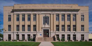
Wilkin County is a county located in the state of Minnesota. Based on the 2010 census, the population of Wilkin County was 6,576. Its
county seat is Breckenridge. The county is named for Colonel Alexander Wilkin, a lawyer who served as Minnesota's US marshal and was later
killed in the Civil War.
Wilkin County is part of the Wahpeton, ND-MN Micropolitan Statistical Area, which is included in the Fargo-Wahpeton, ND-MN Combined
Statistical Area.
Etymology - Origin of Wilkin County Name
Named for Colonel Alexander Wilkin, US marshal for Minnesota and secretary of the Minnesota Territory, 1851-53; killed during the Civil War at the battle of Tupelo, Mississippi, 1864.
Demographics:
County QuickFacts: CensusBureau Quick Facts
Wilkin County History
Wilkin County was originally established as Toombs County on March 8, 1858, named after Robert Toombs (1810-85) of
Georgia, who had been a member of Congress, 1845-53, and was US senator, 1853-61. Mr. Toombs became a leading disunionist, then a
Confederate secretary of state in 1861, and later was a Confederate general. In 1863, the county was renamed Andy Johnson County after
President Andrew Johnson and to disassociate with Mr. Toombs. The county again changed its name to Wilkin County on March 6, 1868.
Toombs County was formed in 1868 from Pembina County. It is the parental county for Traverse County, and now are parts of Clay, Otter Tail,
Grant, Stevens, Douglas and Pope counties.
Geography: Land and Water
As reported by the Census Bureau, the county has a total area of 751 square miles (1,950 km2), of which 751 square miles (1,950 km2) is land and 0.2 square miles (0.52 km2) (0.03%) is water
Neighboring Counties
Bordering counties are as follows:
- Clay County (north)
- Otter Tail County (east)
- Grant County (southeast)
- Traverse County (south)
- Richland County, North Dakota (southwest)
- Cass County, North Dakota (northwest)
Education


Click Image to Enlarge
