


Click Image to Enlarge
Minnesota Counties
There are eighty-seven Counties in Minnesota. On October 27, 1849 nine large Minnesota Counties were created. Among them were Benton, Dahkotah, Itasca, Ramsey, Mahkahta, Pembina, Wabashaw, Washington, and Wahnata. Of those Benton, Dakota, Itasca, Ramsey, Wabasha, and Washington still exist as their original name. With the creation of Kittson County on March 9, 1878, Pembina County no longer existed. When Minnesota was organized as a state, 57 of the present 87 Counties were established. The last county to be created was Lake of the Woods County in 1923Yellow Medicine County, Minnesota
Yellow Medicine County Education, Geography, and History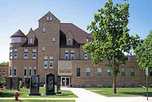
Yellow Medicine County is a county located in the State of Minnesota. Based on the 2010 census, the population was 10,438. Its county seat is
Granite Falls. The county name is based on a plant which the native Dakota people used the yellow root of for medicinal purposes.
The Upper Sioux Indian Reservation is entirely within the county.
Etymology - Origin of Yellow Medicine County Name
Named for Yellow Medicine River. Yellow medicine is a translation of the Dakota name Pajutazee, in reference to yellow-rooted plants used for medicinal purposes found along river.
Demographics:
County QuickFacts: CensusBureau Quick Facts
Yellow Medicine County History
Prior to 1849, Yellow Medicine County, was under federal jurisdiction and was officially known as a part of
Wisconsin Territory. At this time the territory was mostly inhabited by the Chippewa Tribe to the north and Dakota Tribe to the south. In
1849, Yellow Medicine, became part of Minnesota Territory and was a part of Dakota and Wabasha counties. According to the treaties of 1850,
when tribes of the Sioux surrendered title to their lands in Minnesota, a tract of land ten miles wide on each side of the Minnesota River was
reserved as Dakota Territory. Missionaries quickly moved in after the new Dakota territory was established. In 1852, Dr. Thomas Williamson, a
medical missionary with the Presbyterian Church, established the Pejuhatazizi Mission. "Pejuhatazizi" is a Dakota name meaning "Yellow
Medicine", the name of a plant used by the Dakota for medicinal purposes. In 1854, Stephen R. Riggs, another Presbyterian, established the
Hazel Creek Mission. These two missions were located about five miles south of Granite Falls in what is now Minnesota Falls Township. The
government established the Upper Sioux Agency in 1854 in what is now Sioux Agency Township. During the Sioux Uprising of 1862, the Agency,
missions, and several white settlements were destroyed and as a result of the uprising the Dakota lands were declared forfeit. Consequently,
white settlement began again in 1865. At this time Yellow Medicine was a part of Redwood County, MN. The early settlers were largely
Scandinavian and German with smaller concentrations of English, Irish, Czech, and Bohemian.
Yellow Medicine County was created by a legislative act on March 6, 1871. board of three commissioners met on January 1, 1872 in Yellow
Medicine City, which became the first county seat. In the spring of 1874, Granite Falls became the county seat and the first courthouse,
containing a court room and three small offices was completed on the site of the present jail. Then in 1888, this building was replaced with a
two story stone structure which still acts as the court house today on Ninth Avenue in Granite Falls. Twenty-one townships and ten communities
were established in the new county between 1871 and 1890. The communities include Granite Falls, Canby, Clarkfield, Wood Lake, Echo, Hanley
Falls, Porter, Hazel Run, St. Leo, and Burr. A Dakota settlement of about 150 people is located three miles south of Granite Falls. Each
community is authentic and has its own rich history to portray to their visitors.
Geography: Land and Water
As reported by the Census Bureau, the county has a total area of 763 square miles (1,980 km2), of which 759 square miles (1,970 km2) is land and 4.1 square miles (11 km2) (0.5%) is water.
Yellow Medicine County has an area of 758 square miles.It is 54 miles long from east to west and from 12 miles north and south at the west end to 21 miles at the eastern boundary. The elevation of the county ranges from 1,739 feet near the southwest corner of the county to 860 feet where the Minnesota River flows out of the county. The mean elevation is 1,165 feet above sea level. The soil for the most part is good black prairie till. Underlying the glacial drift, which covers the entire county, is an irregular layer of igneous gneiss rock which crops out along the Minnesota River in the east end. The average mean temperature is about 45 degrees; the average rainfall is 25.13 inches; the average snowfall 41.2 inches. The land is well watered and drained by the Minnesota River and its tributaries; the Lac Qui Parle and Yellow Medicine rivers.
Neighboring Counties
Bordering counties are as follows:
- Lac qui Parle County (north)
- Chippewa County (northeast)
- Renville County (east)
- Redwood County (southeast)
- Lyon County (south)
- Lincoln County (southwest)
- Deuel County, South Dakota (west)
Education


Click Image to Enlarge
