


Click Image to Enlarge
Montana Counties
There are fifty-six counties in Montana. Montana has two consolidated city-counties- Anaconda with Deer Lodge County and Butte with Silver Bow County. The portion of Yellowstone National Park that lies within Montana was not part of any county until 1997, when part of it was nominally added to Gallatin County, and the rest of it to Park County.Big Horn County, Montana
Big Horn County Education, Geography, and History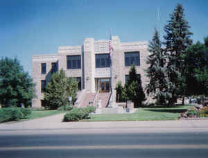
Big Horn County is a county located in the state of Montana. Based on the 2010 census, the population was 12,865. The county seat is Hardin. The county, like the river and mountain range, were named for the bighorn sheep in the Rocky Mountains. The county was founded in 1913. It is north from the Wyoming state line.
Etymology - Origin of Big Horn County Name
The county, like the river and mountain range, were named for the bighorn sheep in the Rocky Mountains.
Demographics:
County QuickFacts: CensusBureau Quick Facts
Big Horn County History
Big Horn County was established on January 13, 1913 from Rosebud and Yellowstone Counties. The county is 5,025 square miles, equaling 3,250,000 acres, and includes the Crow and Northern Cheyenne Indian Reservations. The courthouse was built in 1937 with the help of the WPA (Works Progress Administration). The rock for the courthouse was quarried from Lime Kiln near Fort Smith, MT.
Founded in 1907, Hardin is the youngest and largest town in Big Horn County and serves as the county seat. The town site was purchased from the Lincoln Land Company of Lincoln, Nebraska. C. H. Morill, President of the company, named the new town Hardin in honor of his good friend, Samuel H. Hardin, a cattleman who came to this territory from Texas.
Geography: Land and Water
As reported by the Census Bureau, the county has a total area of 5,015 square miles (12,988 km2), of which,
4,995 square miles (12,936 km2) of it is land and 20 square miles (51 km2) of it (0.40%) is water. Most of the
county's land area comprises Indian reservations: The Crow Indian Reservation covers 64.2 percent of its area, while
the Northern Cheyenne Indian Reservation covers another 6.37 percent.
Neighboring Counties
Bordering counties are as follows:
- Carbon County, Montana - west
- Yellowstone County, Montana - northwest
- Treasure County, Montana - north
- Rosebud County, Montana - northeast
- Powder River County, Montana - east
- Sheridan County, Wyoming - south
- Big Horn County, Wyoming - southwest
Education


Click Image to Enlarge
