


Montana State Almanac: Facts and Figures
Quick Facts, Figures, and Overview of the State of Montana
Montana is one of the Mountain states of the US. Montana is bordered by Canadian provinces British Columbia, Alberta, and Saskatchewan to the north, North Dakota and South Dakota to the east, Wyoming to the south, and Idaho to the west. Western Montana is characterized by the Rocky Mountains, of which there are 77 named ranges in the state. Created out of the Idaho Territory in 1864, the name Montana is a derivation of the Latin word "montaanus" which means mountainous.
Montana has had an economy based on its diversified natural resources. The state is divided into two distinct physical and economic regions: the Rocky Mts. in the West produce lumber and metal ores, and the Great Plains in the East produce petroleum, coal, and agricultural goods. Fields of grain cover much of Montana's plains. It ranks high among the states in wheat and barley, with rye, oats, flaxseed, sugar beets, and potatoes as other important crops. Sheep and cattle raising make significant contributions to the economy.
Montana Almanac: Facts on the State of Montana |
|||
|---|---|---|---|
| Official Name | Montana | ||
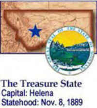
| Capital | Helena | ||
| Nicknames | Treasure State ... and more | ||
| Motto | Oro y Plata (Gold and Silver) | ||
| Location Region |
46.59652 N, 112.02038 W Great Plains Northwestern Northwest, Pacific Rocky Mountains |
||
| Constitution Ratified | 1972 | ||
| Statehood | November 08, 1889 41st state |
||
| Population | 989,415 (2010) 6.20 sq. mi. 44th |
||
| Largest City (by population) |
10 largest cities (2010): Billings, 104,170; Missoula, 95,802; Great Falls, 58,505; Bozeman, 37,280; Butte-Silver Bow,1 34,200; Helena, 28,190; Kalispell, 19,927; Havre, 9,310; Anaconda-Deer Lodge County, 9,298; Miles City, 8,410 | ||
| Bordering States | North: Canadian provinces of British Columbia, Alberta, and Saskatchewan East: North Dakota and South Dakota South: Wyoming and Idaho West: Idaho. (Continental Divide forms much of the Southwestern boundary) |
||
| Major Industry | farming (wheat, sugar beets), cattle ranching, mining (gold, silver, copper, coal), oil, lumber, tourism | ||
| Major Rivers | Yellowstone River, Missouri River, Clark Fork River | ||
| Major Lakes | Flathead Lake, Fort Peck Lake | ||
| Montana Counties | 56 Counties in Montana | ||
| Largest County (by population) |
Yellowstone County 147,972 (2010) 2,635 sq. mi. |
||
| Largest County (by area) |
Beaverhead County 5,543 sq. mi. |
||
| State forests | 7 | ||
| State parks | 50 | ||
| Electoral Votes | 3 | ||
| US Congress | 2 Senators; 1 Representative | ||
| Time Zone | Mountain Standard Time | ||
| Zip Codes | NANPA | ||
| State Quick Facts | Census Bureau Quick Facts | ||
Montana Climate and Weather |
|
|---|---|
| Montana's winters can be bitterly cold - though temperatures in January range 11 to 35 F/-11 to -2 C, most places experience at least a week below 0 F/-17 C. If you're primarily interested in the state's historical, cultural and sightseeing attractions, you would do well to visit in the summer months. This is when the greatest number of resorts, hotels and attractions are open and when the greatest number of events are scheduled. Expect the warmest temperatures in July, when the statewide range is 64-88 F/17-31 C, though most places will record 90 F/32 C a few times each summer. Parts of the state west of the Continental Divide are generally cooler than the southeast. On summer nights, expect temperatures of 50-60 F/10-15 C (a sweater will be more than welcome). May-July is the rainiest part of the warm season. | |
| Highest Temperature | 117 degrees July 5, 1937 |
| Lowest Temperature | -70 degrees January 20, 1954 - Rogers Pass |
| Avg. Temp: High - Low |
86.6 degrees - 8.1 degrees |
Montana Points of Interest |
|
| Glacier National Park, Little Bighorn Battlefield and National Monument, Ski Resorts, and Yellowstone National Park. Tourist attractions also include hunting, fishing, skiing, and dude ranching. Glacier National Park, on the Continental Divide, has 26 glaciers, 200 lakes, and many streams with good trout fishing. Other major points of interest include Virginia City, Fort Union Trading Post and Grant-Kohr's Ranch National Historic Sites, and the Museum of the Plains Indians at Browning, and much much more | |
Montana Highest, Lowest, and Mean Elevations (Feet) |
|
| Mean Elevation: 3,400 feet | |
| Highest Point: Granite Peak: 12,799 feet
|
|
| Lowest Point: | Kootenai River 1,800 feet |
Montana Land Area (Square Miles) |
|
| Geographic Center | In Fergus County, 11 mi. W of Lewistown Longitude: 109°38.3'W Latitude: 41°1.9'N |
| Total Area | 147,042.40 sq. mi. 4th |
| Land Area | 145,552.43 sq. mi. 88.99% |
| Water Area | 1,489.96 sq. mi. 1.01% |
| Forested Land Area | 24.8% |
| Dimensions (Length - Width) |
630 miles - 280 miles |
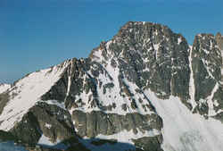 The Custer National Forest is home
to 12,799 ft. Granite Peak, the tallest mountain in Montana. Granite Peak is located in the Absaroka-Beartooth Wilderness, an arduous 21 to 25 mile
trek (round trip) from either of three approaches.
The Custer National Forest is home
to 12,799 ft. Granite Peak, the tallest mountain in Montana. Granite Peak is located in the Absaroka-Beartooth Wilderness, an arduous 21 to 25 mile
trek (round trip) from either of three approaches.Anaconda-Deer Lodge, Beaverhead, Big Horn, Blaine, Broadwater, Butte-Silver Bow, Carbon, Carter, Cascade, Chouteau, Custer, Daniels, Dawson, Fallon, Fergus, Flathead, Gallatin, Garfield, Glacier, Golden Valley, Granite, Hill, Jefferson, Judith Basin, Lake, Lewis And Clark, Liberty, Lincoln, Madison, McCone, Meagher, Mineral, Missoula, Musselshell, Park, Petroleum, Phillips, Pondera, Powder River, Powell, Prairie, Ravalli, Richland, Roosevelt, Rosebud, Sanders, Sheridan, Stillwater, Sweet Grass, Teton, Toole, Treasure, Valley, Wheatland, Wibaux, Yellowstone

