Montana Counties
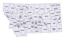
There are fifty-six counties in Montana. Montana has two consolidated city-counties- Anaconda with Deer Lodge County and Butte with Silver Bow County. The portion of Yellowstone National Park that lies within Montana was not part of any county until 1997, when part of it was nominally added to Gallatin County, and the rest of it to Park County.Glacier County, Montana
Glacier County Education, Geography, and History
Glacier County is located in the state of Montana. Based on the 2010 census, the population was 13,399. The county is located in northwestern Montana between the Great Plains and the Rocky Mountains, known to the Blackfeet as the "Backbone of the World". The county is geographically and culturally diverse and includes the Blackfeet Indian Reservation, Glacier National Park, and Lewis and Clark National Forest. The county is bordered by 75 miles of international boundary with two ports of entry (Piegan and Del Bonita) open year-round and one seasonal (Chief Mountain) international border crossing into Alberta, Canada.
Etymology - Origin of Glacier County Name
Glacier National Park, which borders the county
Demographics:
County QuickFacts: CensusBureau Quick Facts
Glacier County History
The area now known as Glacier County became a part of the United States in 1803 when President Thomas Jefferson negotiated the "Louisiana Purchase" deal with France. The land was then occupied by the Blackfeet Indians who had moved down from the Saskatchewan area of Canada sometime after 1730.
The Lewis and Clark Expedition entered Montana in 1805 but it was not until July of 1806 when Captain Meriwether Lewis led a small team up the North Fork of the Marias River, (now known as the Cut Bank River) into what has become Glacier County.
Due to conflicts with the Blackfeet Tribe few pioneers ventured into this territory. Only a few trappers and fur traders found it worth while to face the hardships to survive here. As time went on more interest was found in mining, farming and ranching. This interest was eventually focused towards the now Glacier County.
Oil was first discoverd in Montana in 1864, however it was not until 1902 when a copper miner "Sam Somes" accidentally found oil in the Swift Current Creek region. A few more wells were drilled in the area but then interest was lost until the 1920's when a large oil strike near Shelby revived the interest again. By 1931 a well in Cut Bank was into production and by the mid 1930's the Cut Bank field was doing extremely well and went on to become Montana's top ranking oil field in 1936. While most of the oil industry in Montana suffered during the depression the Cut Bank field held on and managed to increase it's oil production. There are still many oil wells standing in Glacier County and although production has dropped off considerably, many are still in operation.
The Railroad played a great part in the overall development of Glacier County. The railroad moved into Montana in the late 1800's to compliment the mining and livestock industries and was into our area around 1890. Cut Bank became a vital part to the Railroad as the river provided the much needed water for the operation of the steam locomotives. A "Round House" was constructed here in order to turn around the big "Mallets" that were used here for the sole purpose of pulling the trains back and forth across the mountians. The Railroad also had a big roll in the development and operation of the oil industry, and still has a big part in the farming operations.
When Montana was divided into counties in 1865 we were then a part of Chouteau County, with Fort Benton as our County seat. In 1893 Chouteau County was split up and we became a part of Teton County and the town of Choteau was the County seat. (Note: A difference in spelling of Chouteau County and the town of Choteau.)
Glacier County was created 17 February 1919 from Teton County. County seat: Cut Bank. Teton County was divided again in 1919 and Glacier County was formed. After a much heated battle and election Cut Bank won the County seat position over Browning.
Geography: Land and Water
As reported by the Census Bureau, the county has a total area of 3,037 square miles (7,866 km2), of which,
2,995 square miles (7,756 km2) of it is land and 42 square miles (110 km2) of it (1.40%) is water. About 70.85
percent of the county's land area lies within the Blackfeet Indian Reservation. Another 20.58 percent lies within
Glacier National Park at the county's extreme west. The balance of the county, the extreme eastern section, is
centered around its largest city, Cut Bank.
Neighboring Counties
Bordering counties are as follows:
- Flathead County, Montana - west
- Pondera County, Montana - south
- Toole County, Montana - east
- Cardston County, Alberta - north
- Improvement District No. 4, Alberta - north
- Warner County No. 5, Alberta - northeast
Education


