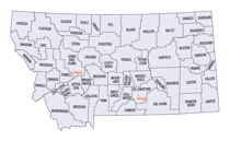
Montana Counties
There are fifty-six counties in Montana. Montana has two consolidated city-counties- Anaconda with Deer Lodge County and Butte with Silver Bow County. The portion of Yellowstone National Park that lies within Montana was not part of any county until 1997, when part of it was nominally added to Gallatin County, and the rest of it to Park County.Golden Valley County, Montana
Golden Valley County Education, Geography, and History
Golden Valley County is a county located in the state of Montana. Based on the 2010 census, the population was 884, making it the
third-least populous county in Montana. Its county seat is Ryegate.
Golden Valley County is included in the Billings, MT Metropolitan Statistical Area.
Etymology - Origin of Golden Valley County Name
Probably named in a promotional attempt to lure settlers to the area
Demographics:
County QuickFacts: CensusBureau Quick Facts
Golden Valley County History
Golden Valley County was created 4 October 1920 from Musselshell and Sweet Grass Counties. County seat: Ryegate Parts of Golden Valley County have at various and previous times been part of Fergus, Yellowstone, Meagher, and Wheatland Counties. Golden Valley is one of the smaller counties in the state. With only 1172 square miles. It extends approximately 50 miles in a north-south direction from the Big Snowy Mountains in the north to the Big Coulee in south. It is approximately 30 miles wide in an east-west direction. The course of the Musselshell River traverses the county in this direction. Golden Valley County was named because of the great expectations of this area as a grain-growing agricultural region.
The northern part of the county is predominately stock country and is liberally sprinkled with sagebrush and
grease-wood from the river to the base of the Snowy Mountains. At one time during the homestead days, much of the
land was broken by plow and farmed. The ground proved to be nonproductive as farm land. It does provide excellent
range-land. Many large sheep and cattle ranches occupied this area at one time, but now most of the sheep
enterprises have turned to cattle ranching.
South of the Musselshell river much of the bench land is farmed. Wheat is the main grain crop along with oats and
barley. There is also an abundance of range land here as well. Six miles south of Ryegate is the Big Coulee. This
wide open valley surrounded by sandstone rims drew many settlers to the area.
Golden Valley County is a sparsely settled county having approximately 1117 people in the entire county. It has only
2 incorporated towns; Ryegate, the county seat and Lavina. Both towns are situated on the Musselshell River. Lavina
started as a stage stop and provided a river crossing of the Musselshell River for stage lines running from Billings
into the Lewistown area. Ryegate had its' beginnings with the coming of the Milwaukee Railroad in 1910. The
Milwaukee Railroad no longer runs through Ryegate. The railroad abandoned the tracks in 1980. The town of Ryegate
runs east and west, due to sandstone rim rock to the north and the Musseshell River to the south.
In the spring of 1938 Golden Valley County experienced a memorable murder case in which a rancher murdered two of
his ranch hands and also killed a deputy sheriff in a genuine "gun battle", reminiscent of the old west. In December
of 1939 the rancher was hung from gallows erected on the courthouse lawn in Ryegate. This was one of the last
hangings in the state of Montana.
With the 40's and the war years the economy of Golden Valley County blossomed, as it did throughout the state. In
the following years up to the present the economy has fluctuated.
Golden Valley County is run by a 3 member elected county commission board. Both towns have town councils with an elected Mayor.
Geography: Land and Water
As reported by the Census Bureau, the county has a total area of 1,176 square miles (3,047 km2), of which, 1,175 square miles (3,044 km2) of it is land and 1 square miles (3 km2) of it (0.09%) is water.
Golden Valley County is located at the base of the Snowy Mountains in the central part of Montana. The landscape is
dotted with sagebrush, greasewood, native grasses, cottonwood trees, pine trees, rolling hills, and sandstone rim rocks.
Buffalo and Native Americans once made this area their home. Chief Joseph of the Nez Perce stopped at what is now
Ryegate in Sept. of 1877 on his doomed trek to Canada.
Neighboring Counties
Bordering counties are as follows:
- Fergus County, Montana - north
- Musselshell County, Montana - east
- Yellowstone County, Montana - southeast
- Stillwater County, Montana - south
- Sweet Grass County, Montana - southwest
- Wheatland County, Montana - west
Education


