Montana Counties
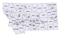
There are fifty-six counties in Montana. Montana has two consolidated city-counties- Anaconda with Deer Lodge County and Butte with Silver Bow County. The portion of Yellowstone National Park that lies within Montana was not part of any county until 1997, when part of it was nominally added to Gallatin County, and the rest of it to Park County.Powder River County, Montana
Powder River County Education, Geography, and History
Powder River County is a county located in the state of Montana. Based on the 2010 census, the population was 1,743. Its county seat is Broadus.
Etymology - Origin of Powder County Name
The Powder River, which in turn was named for gunpowder-like sand along its banks
Demographics:
County QuickFacts: CensusBureau Quick Facts
Powder County History
Powder River County was created 7 March 1919 from Custer County.County seat: Broadus
Present day Powder River County was probably first entered by European's in the early 1800s by French fur trappers. In the summer of 1865, the United States government sent over 2,600 US soldiers to the Powder River Country to combat Native Americans from the Cheyenne, Lakota Sioux, and Arapaho tribes. The column became known as the Powder River Expedition. On September 8, 1865, in present-day Powder River County, it engaged in the Battle of Dry Ford, about 5 miles (8.0 km) northeast of the future site of Broadus. On March 17, 1876, the Battle of Powder River occurred in the south-central part of the county, about 34 miles (55 km) southwest of Broadus. On November 1, 1878, Powderville became the first establishment in the county, as the Powder River Telegraph Station, on the Fort Keogh to Deadwood, South Dakota telegraph line. On April 5, 1879, the Mizpah Creek Incidents began near the Powderville telegraph station in the extreme northern part of the county. In the early 1880s, a large area of Southeastern Montana became Custer County, Montana, including the present area encompassed by Powder River County. In February, 1900, the Broadus post office was established, named after the Broaddus family. In October, 1918, publication of the newspaper, the Broadus Independent, (now called the Powder River Examiner) began in Broadus, and is still published today. In 1919, Powder River County, Montana was formed from southern Custer County, and in an election in 1920, Broadus was chosen as the county seat of the newly established Powder River County.
Geography: Land and Water
As reported by the Census Bureau, the county has a total area of 3,298 square miles (8,542 km2), of which,
3,297 square miles (8,540 km2) of it is land and 1 square miles (2 km2) of it (0.02%) is water.
Neighboring Counties
Bordering counties are as follows:
- Big Horn County, Montana - west
- Rosebud County, Montana - west
- Custer County, Montana - north
- Carter County, Montana - east
- Crook County, Wyoming - southeast
- Campbell County, Wyoming - south
- Sheridan County, Wyoming - southwest
Education


