New York Counties
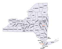
There are sixty-two counties in the State of New York. The first twelve counties in New York were created immediately after the British annexation of the Dutch colony of New Amsterdam, although two of these counties have since been abolished. The most recent county formation in New York was in 1912, when Bronx County was created from the portions of New York City that had been annexed from Westchester County.Jefferson County, New York
Jefferson County Education, Geography, and History
Jefferson County is a county located in the state of New York. Based on the 2010 census, the population was 116,229. Its county seat is
Watertown. The county is named after Thomas Jefferson, third President of the United States of America. It is adjacent to Lake Ontario,
southeast from the Canadian border of Ontario.
Jefferson County comprises the Watertown-Fort Drum, NY Metropolitan Statistical Area.
Etymology - Origin of Jefferson County Name
Named in honor of Thomas Jefferson, third President of the United States
Demographics:
County QuickFacts: CensusBureau Quick Facts
Jefferson County History
Jefferson County was formed, 28 March 1805, from Oneida County. Oneida, in turn, came 15 Mar 1798 from Herkimer and
included all of present day Jefferson and Lewis County, along with parts of Clinton, Madison, and Oswego. Herkimer came
out of Montgomery. Montgomery, under its first name, Tryon, was formed from Albany County, one of the original counties
of New York Province.
Jefferson County was named in honor of our third president, Thomas Jefferson. It occupies that corner of New York State
where the St. Lawrence River empties out of Lake Ontario, and thus has a Canadian border. The nearness of Canada and
these waterways have been important to Jefferson County both historically and genealogically. It is bounded on the
northeast by St. Lawrence County, on the east by Lewis County, and on the south by Oswego County.
When Jefferson County was created in 1805, it included parts of eight Oneida towns: Champion and Watertown came from
Mexico 14 March 1800; Adams was formed from Mexico 1 April 1802, and at the same time Brownville from Leyden; Ellisburg
from Mexico 22 February 1803; Lorraine, originally Malta, from Mexico 24 March 1804; Rodman, then called Harrison, from
Adams 24 March 1804; Rutland from Watertown 1 Apr 1802. Watertown is the county seat, containing the usual county
offices. Notable features of Jefferson County include the Thousand Islands, the international Thousand Island Bridge, a
continuation of Federal Interstate Highway 81 right into Canada, and Fort Drum. The military reservation of Fort Drum
has preempted a large area of western Jefferson County, obliterating many landmarks and making small cemeteries very
difficult to access. Large areas of the Towns of Le Ray and Philadelphia, nearly half of the Town of Antwerp, and most
of the Town of Wilna are included in the Fort Drum boundaries.
Rivers of Jefferson County: the Black River rises south of Jefferson County, runs through Watertown to empty into Black
River Bay in Lake Ontario. Perch River drains Perch Lake, and is now a state game management area. It also discharges
into Black River Bay. Indian River, flowing through the Town of Theresa, is a tributary of the Oswegatchie which
eventually reaches the St. Lawrence River in St. Lawrence County. Chaumont River runs through the towns of Orleans,
Clayton and Lyme to empty into Lake Ontario in Chaumont Bay. The two branches of Sandy Creek, in the southern part of
the county, also discharge into Lake Ontario.
The section of New York State now comprising the county of Jefferson was a formidable frontier wilderness without permanent settlement either by Native American or European settlers until after the Revolutionary War. Ownership was claimed by the Oneida Indian nation because of exposure to frequent raids from hostile tribes across the St. Lawrence River, not even the Oneida tarried very long in the region while on occasional hunting or trapping expeditions.
Geography: Land and Water
Jefferson County is on the western side of northern New York State, adjacent to the area where the Saint Lawrence
River exits Lake Ontario. It is almost due north of Syracuse, and northwest of Utica. The county is at the
international border with Canada.
The Black River, which empties into Lake Ontario, is an important stream in the county. Part of the Tug Hill Plateau
is in the southern part of the county.
The county also includes nearby islands in the St. Lawrence River, including such large islands as Carleton Island,
Grindstone Island, and Wellesley Island.
As reported by the Census Bureau, the county has a total area of 1,857 square miles (4,810 km2), of which, 1,272
square miles (3,295 km2) of it is land and 585 square miles (1,515 km2) of it (31.49%) is water.
Neighboring Counties
Bordering counties are as follows:
- St. Lawrence County, New York - northeast
- Lewis County, New York - southeast
- Oswego County, New York - southwest
- Leeds and Grenville United Counties, Ontario - north
- Frontenac County, Ontario - northwest
Education
Jefferson Community College in Watertown provides higher education within the county.


