New York Counties
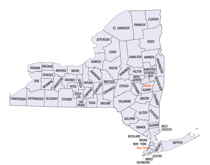
There are sixty-two counties in the State of New York. The first twelve counties in New York were created immediately after the British annexation of the Dutch colony of New Amsterdam, although two of these counties have since been abolished. The most recent county formation in New York was in 1912, when Bronx County was created from the portions of New York City that had been annexed from Westchester County.Orange County, New York
Orange County Education, Geography, and History
Orange County is a county located in the state of New York. Based on the 2010 census, the population was 372,813. The county seat is
Goshen. This county was first created in 1683 and reorganized with its present boundaries in 1798.
Orange County is included in the New York-Newark-Jersey City, NY-NJ-PA Metropolitan Statistical Area. It is in the state's Mid-Hudson Region
of the Hudson Valley.
Etymology - Origin of Orange County Name
Name in honor of William, Prince of Orange, held in high esteem by the first settlers of the region
Demographics:
County QuickFacts: CensusBureau Quick Facts
Orange County History
ORANGE - a county in the S.E. part of New York, has an area of about 770 square miles. It is bounded on the E. by the Hudson river, and on the S. by the State of New Jersey, and is drained by Walkill and Shawangunk rivers, and other smaller streams, which afford valuable water-power. The surface in the S.E. parts is mountainous, and the Shawangunk range passes through the western portion. The other parts of the county are usually, but moderately uneven. The soil is generally fertile, and well adapted to grazing, and the "Orange county butter" is highly esteemed in the New York markets. Indian corn, oats, potatoes, and grass are the staples. In 1850 this county produced 491,074 bushels of corn; 390,834 of oats; 146,331 of potatoes; 96,593 tons of hay, and 3,769,034 pounds of butter. There were 49 flour mills, 36 saw mills, 8 cotton, and 8 woollen factories, 3 iron furnaces, 3 paper mills, 18 tanneries, and 4 oilcloth factories. It contained 67 churches, 9 newspaper offices, 9492 pupils attending public schools, and 912 attending academies or other schools. Iron ore, marble, limestone, and sandstone are abundant. The Hudson river is navigable for ships along the entire eastern border. The Delaware and Hudson canal, and the New York and Erie railroad traverse this county, which is also partly intersected by the Newburg Branch railroad. Seats of justice, Goshen and Newburg. Population, 57,145. page 862 (Baldwin, Thomas and J. Thomas, M.D. New and Complete Gazetteer of the United States. Philadelphia, PA: Lippincott, Grambo, & Co., 1854)
Orange County's first overnight visitor from Europe was the explorer Henry Hudson, who dropped anchor in Newburgh Bay in 1609. European settlement did not follow immediately, however. The Orange County created on November 1, 1683 included half of today's Orange County, but also all of present day Rockland County, where there were a small number of settlers.
Geography: Land and Water
Orange County is in southeastern New York State, directly north of the New Jersey-New York border, west of the
Hudson River, east of the Delaware River and northwest of New York City. It borders the New York counties of
Dutchess, Putnam, Rockland, Sullivan, Ulster, and Westchester, as well as Passaic and Sussex counties in New Jersey
and Pike County in Pennsylvania.
Orange County is the only county in New York State which borders both the Hudson and Delaware Rivers.
Orange County is where the Great Valley of the Appalachians finally opens up and ends. The western corner is set off
by the Shawangunk Ridge. The area along the Rockland County border (within Harriman and Bear Mountain state parks)
and south of Newburgh is part of the Hudson Highlands. The land in between is the valley of the Wallkill River. In
the southern portion of the county the Wallkill valley expands into a wide glacial lake bed known as the Black Dirt
Region for its fertility.
The highest point is Schunemunk Mountain, at 1,664 feet (507 m) above sea level. The lowest is sea level along the
Hudson.
As reported by the Census Bureau, the county has a total area of 839 square miles (2,172 km2), with 816 square
miles (2,114 km2) as land and 22 square miles (58 km2) as water.
Neighboring Counties
Bordering counties are as follows:
- Dutchess County, NY to the east
- Passaic County, NJ to the south
- Pike County, PA to the west
- Putnam County, NY to the east
- Rockland County, NY to the southeast
- Sullivan County, NY to the northwest
- Sussex County, NJ to the south
- Ulster County, NY to the north
- Westchester County, NY to the southeast
Education


