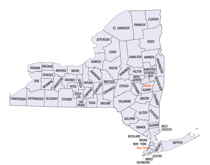
New York Counties
There are sixty-two counties in the State of New York. The first twelve counties in New York were created immediately after the British annexation of the Dutch colony of New Amsterdam, although two of these counties have since been abolished. The most recent county formation in New York was in 1912, when Bronx County was created from the portions of New York City that had been annexed from Westchester County.Suffolk County, New York
Suffolk County Education, Geography, and History
Suffolk County is a suburban county on Long Island and the easternmost county in the state of New York. Based on the 2010 census, the
county's population was 1,493,350, estimated to have increased to 1,502,968 in 2014, making it the fourth-most populous county in New York.
Its county seat is Riverhead, though some county offices are located in Hauppauge. The county was named after the county of Suffolk in
England, from where its earliest European settlers came.
Suffolk County incorporates the easternmost extreme of the New York City metropolitan area. The largest of Long Island's four counties and the
second-largest of 62 counties in New York State, Suffolk measures 86 miles (138 km) in length and 26 miles (42 km) in width at its widest
(including water).
Etymology - Origin of Suffolk County Name
after Suffolk County, England, home of many early settlers
Demographics:
County QuickFacts: CensusBureau Quick Facts
Suffolk County History
Suffolk County was an original county of New York State, one of twelve created in 1683. Its boundaries were substantially the same as at present, with only minor changes in the boundary with its western neighbor, which was originally Queens County but since 1899 has been Nassau County. However, as eastern Suffolk County has become more suburbanized there have been efforts to split the east end of the county off into a new county, called Peconic County.
The first nomadic hunters came here in the last glacial period following caribou herds when Long Island and the mainland of Connecticut were separated by only low-lying marshland. This area is now covered by Long Island Sound. The first known Europeans to sight Long Island were with Verrazano, who sailed along the south shore in 1524. In 1614 Adrian Block, a Dutch explorer, first touched the land here when he went ashore at Montauk and met local Native Americans.
Geography: Land and Water
As reported by the Census Bureau, the county has a total area of 2,373 square miles (6,146 km2), of which, 912
square miles (2,363 km2) of it is land and 1,461 square miles (3,784 km2) of it (61.56%) is water. The highest
elevation in the county, and on Long Island as a whole, is Jayne's Hill in West Hills, at 401 feet (122 m) above sea
level.
Suffolk County occupies the easternmost portion of Long Island, in the southeastern portion of New York State. The
eastern end of the county splits into two peninsulas, known as the North Fork and the South Fork. The county is
surrounded by water on three sides, including the Atlantic Ocean and the Long Island Sound. The eastern end contains
large bays. Suffolk County is divided into 10 towns: Babylon, Brookhaven, East Hampton, Huntington, Islip,
Riverhead, Shelter Island, Smithtown, Southampton, and Southold. Also part of the county, but not considered parts
of the above towns, are the Poospatuck and Shinnecock Indian reservations. Poospatuck is enclaved within Brookhaven
in the Mastic CDP, and Shinnecock is enclaved within Southampton, adjacent to Southampton village, Tuckahoe, and
Shinnecock Hills.
Major facilities include Brookhaven National Laboratory in Upton and Plum Island Animal Disease Center on Plum
Island. Several airports serve commuters and business travelers, most notably Long Island MacArthur Airport in
Islip, Republic Airport in East Farmingdale and Francis S. Gabreski Airport in Westhampton Beach.
Neighboring Counties
Bordering counties are as follows:
- Nassau County, New York - west
- Fairfield County, Connecticut - northwest, water boundary only, across Long Island Sound
- New Haven County, Connecticut - north, water boundary only, across Long Island Sound
- Middlesex County, Connecticut - north, water boundary only, across Long Island Sound
- New London County, Connecticut - north, water boundary only, across Fishers Island Sound
- Washington County, Rhode Island - northeast, water boundary only, across Block Island Sound
Education
Colleges and universities
Suffolk County is home to numerous colleges and universities:
Public
Branches of the State University of New York
Stony Brook University, including Stony Brook Southampton campus
Farmingdale State College
Suffolk County Community College in Riverhead, Selden, and Brentwood
Private
Adelphi University - branch campus at Hauppauge
Briarcliffe College - three campuses, one in Suffolk at Patchogue
Dowling College - campuses in Oakdale, Shirley and Melville
Five Towns College - Dix Hills
Long Island University - branch campuses in Brentwood and Riverhead
New York Institute of Technology-Campus in Central Islip Home to the Vocational Independence Program
Polytechnic Institute of New York University (formerly Polytechnic University, now part of NYU) - has a "Long Island Graduate Center" at
Melville
Saint John's University - has a Graduate Center in Oakdale[36]
Saint Joseph's College - branch campus at Patchogue
SBI-Melville - Sanford-Brown Institute campus at Melville
Touro College
Jacob D. Fuchsberg Law Center - in Central Islip
Touro College School of Health Sciences - in Bay Shore
Watson School of Biological Sciences - Cold Spring Harbor


