


Click Image to Enlarge
North Carolina Counties
North Carolina is divided into one hundred counties. The establishment of North Carolina counties stretches over 240 years, beginning in 1668 with the creation of Albemarle County and ending with the 1911 creation of Avery and Hoke counties. Five counties have been divided or abolished altogether, the last being Dobbs County in 1791.Alamance County, North Carolina
Alamance County Education, Geography, and History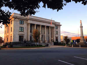
Alamance County is a county located in the state of North Carolina. Based on the 2010 census, the population was 151,131. Its county seat
is Graham. Formed in 1849 from Orange County to the east, Alamance County has been the site of significant historical events, textile
manufacturing, and agriculture in North Carolina.
Alamance County comprises the Burlington, NC Metropolitan Statistical Area, which is also included in the Greensboro-Winston-Salem-High Point,
NC Combined Statistical Area.
Etymology - Origin of Alamance County Name
The name is supposedly derived from the Indian word meaning "blue clay." The county gets its name from the Alamance Creek on the banks of which was fought the battle between the colonial troops under Governor Tryon and the Regulators on May 17, 1771.
Demographics:
County QuickFacts: CensusBureau Quick Facts
Alamance County History
Alamance was formed in 1849 from Orange. The name is supposedly derived from the Indian word meaning "blue clay." The county gets its name from the Alamance Creek on the banks of which was fought the battle between the colonial troops under Governor Tryon and the Regulators on May 17, 1771. It is in the central part of the State and is bounded by Orange, Chatham, Randolph, Guilford, and Caswell counties. The present land area is 429.99 square miles and the 2000 population was 130,800. The first court was ordered to be held at Providence Meeting House until a courthouse could be erected, provided the justices of the peace at the first session did not select some other place for all subsequent courts until the buildings were completed. Commissioners were named to select a site in the center of the county, acquire land, erect a courthouse, and lay out a town by the name of Graham. Graham was established in 1851 and is the county seat.
Geography: Land and Water
As reported by the Census Bureau, the county has a total area of 435 square miles (1,130 km2), of which 424 square miles (1,100 km2) is
land and 11 square miles (28 km2) (2.5%) is water.
The county is in the Piedmont physiographical region. The county has a general rolling terrain with the Cane Creek Mountains rising to over
970 ft (300 m) in the south central part of the county just north of Snow Camp. Bass Mountain, one of the prominent hills in the range, is
home to a world-renowned bluegrass music festival every year. There are also isolated monadnocks in the northern part of the county that rise
to near or over 900 ft (270 m) above sea level.
The largest river that flows through Alamance County is the Haw River, which feeds into Jordan Lake in Chatham County, eventually leading to
the Cape Fear River. The county is also home to numerous creeks, streams, and ponds, including Great Alamance Creek, where a portion of the
Battle of Alamance was fought. There are three large municipal reservoirs: Lake Cammack, Lake Mackintosh, and Graham-Mebane Lake (formerly
Quaker Lake).
Neighboring Counties
Bordering counties are as follows:
- Caswell County - north
- Orange County - east
- Rockingham County - northwest
- Chatham County - south
- Randolph County - southwest
- Guilford County - west
Education
Alamance County is served by the Alamance-Burlington School System, several private elementary and secondary schools, Alamance Community College, and Elon University.


Click Image to Enlarge
