


North Carolina Geography: The Land
Geography and Landforms of North Carolina
 Find an overview of North
Carolina geography, topography, geographic land regions, land areas, and major rivers.
Find an overview of North
Carolina geography, topography, geographic land regions, land areas, and major rivers.
Access North Carolina almanac furnishing more details on the state geography, geographical and land regions, climate and weather, elevation, land areas, bordering states, and other statistical data.
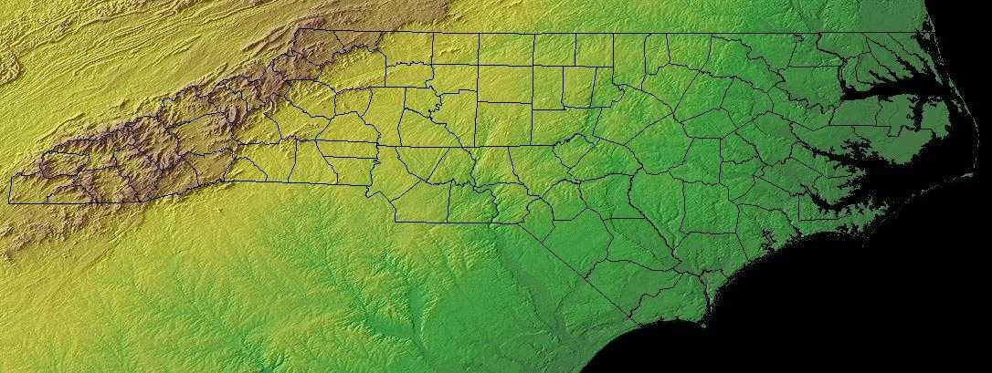
North Carolina's six largest cities: Charlotte, Raleigh, Greensboro, Winston-Salem, Durham, and Fayetteville are in the Piedmont Plateau region.
North Carolina Highest, Lowest, & Mean Elevations |
|
|---|---|
| Mean Elevation | 700 ft |
| Highest Point | Mt. Mitchell 6,684 ft. |
| Lowest Point | Atlantic Ocean Sea level |
North Carolina Land Area (Square Miles) |
|
| Geographic Center | In Chatham County, 10 mi. NW of Sanford Longitude: 79° 27.3'W Latitude: 35° 36.2'N |
| Total Area | 53,818.51 sq. mi. 28th |
| Land Area | 48,710.88 sq. mi. 90.52% |
| Water Area | 5,107.63 sq. mi. 9.48% |
| Forested Land Area | 61.8% |
| Dimensions (Length - Width) |
500 miles - 150 miles |
North Carolina: Physiographic Regions
North Carolina extends across three major physiographic regions of the United States
- the Coastal Plain (or tidewater area),
- the Piedmont, and the
- Appalachian Mountains.
South Atlantic Coastal Plain
This coastal area offers extensive commercial and sport fishing, and thousands of tourists visit the state's many beaches. A slender chain of islands known as the Outer Banks protects the North Carolina coast.
The South Atlantic Coastal Plain covers northeastern Florida, the southern half of Georgia and the eastern halves of South Carolina and North Carolina.
Its western boundary is the fall line that marks the beginning of the hilly Piedmont and its eastern boundary is the Atlantic Ocean. As part of a continuous
Coastal Plain that extends from New York to Texas, it has arbitrary boundaries at the Alabama-Georgia border and at the North Carolina-Virginia border,
extending into the southeast corner of Virginia only to capture the very Southeastern Great Dismal Swamp. The southeastern boundary marks a broad transitional
zone into Peninsular Florida. The Atlantic coast is lined with barrier islands that support sand dune and maritime forest habitats and are backed by
marshland. Estuaries are less saline marsh nearest the coast, and river valleys become increasingly wooded farther inland, supporting significant areas
of bottomland hardwood forest. Pocosins and Carolina bays are non-alluvial forested wetlands unique to this physiographic area. Uplands were historically
dominated by fire-maintained pine forests, with longleaf nearer the coast and on sandy soils inland and a mixture of shortleaf, loblolly, and hardwoods
elsewhere.
The Florida Uplands run about 275 miles west to east, along the northern edge of the Florida Panhandle and then extends south into the central area of the Florida peninsula. The width of the northern Florida Uplands varies from around 30 to 50 miles and is characterized by low rolling hills of red clay. Hard and softwood forests are plentiful. The section of the Florida Uplands that extends south into the peninsula, covers an area about 100 miles wide and 160 miles long. This area extends from the north, south and to the east, to separate the two sections of the East Gulf Coastal Plain and to separate the East Gulf Coastal Plain from the Atlantic Coastal Plain. The landscape in the southern Florida Uplands is characterized by low hills and many lakes. Though the Florida Uplands are only 200-300 feet above sea level, they are still higher than the regions of the Atlantic Coastal Plain and the East Gulf Coastal Plain. The highest point in Florida is found in the Florida Uplands that run along the northern edge of the panhandle. Just south of the Alabama border, west of Paxton, Britton Hill is 345 feet above sea level and is the lowest state high point in the nation.
Southern Blue Ridge
This region has more than 200 mountains that exceed 5,000 feet or more. This area, known for its beauty. Tourism is an outstanding business. The valleys and some of the hillsides serve as small farms and apple orchards; and here and there are business enterprises, ranging from small craft shops to large paper and rayon manufacturing plants.
The Southern Blue Ridge is an area of rugged mountains, long broad ridges, steep slopes, and deep ravines. It straddles the border between Tennessee and North Carolina, extending south into northeast South Carolina and northwest Georgia and north into Virginia. High Peaks spruce-fir forest grades at lower elevations into northern hardwood forest or hemlock-white pine forest on steep, north-facing slopes and Appalachian oaks on drier sites. The Appalachian oak type is the most widespread forest type in the area. Mixed mesophytic hardwood forests, also called cove forests, over on more mesic sites at low to mid-elevations. Various southern yellow pine mixes occur on dry ridges, often associated with a fire regime. There are also riparian forest types along valleys at various elevations, primarily in the lowlands. Disturbance, including fire, grazing, and storm damage, plays a major role in determining the distribution and successional status of many of these forest types.
Southern Piedmont (Southern Appalachia)
This area is dotted with many small rolling farms, The Piedmont Plateau is mostly a manufacturing area in which the chief industries are furniture, tobacco, and textiles. The southeastern section of the Piedmont is known as the Sandhills where peaches grow in abundance. The Sandhills, with its nationally famous golf courses and stables, is well known as a winter resort area.
The Southern Piedmont extends through central North Carolina, South Carolina, and Georgia and into eastern Alabama. The area is characterized by irregular plains and open hills with occasional tablelands. Elevations generally range from about 30 meters to 100 meters, but rise to about 400 meters at the interface with the Southern Blue Ridge. Numerous and diverse rivers comprise a major feature of the landscape. Although the Piedmont is geologically part of Southern Appalachia, the types of vegetation that characterize the region encompass a broad transition from upland forest types to the coastal plain. By most accounts, Piedmont forests were dominated by hardwoods at the time of early European settlement, and the extent far exceeded what exists today. However, the Piedmont was by no means entirely forested prior to European settlement. Eastern grasslands and savannas were extensive and present as late as the 1700's. Because Native American settlements were apparently common in the Piedmont, agricultural fields and other larger openings were historically part of the landscape.
Potential natural forest vegetation in the Southern Piedmont is oak-hickory-pine and Southern mixed forests. Southern red, northern red, chestnut, white, post and black are the most prevalent oaks. Shagbark, pignut, and mockernut are common hickory species. Shortleaf and loblolly are dominant pine species, with scattered longleaf stands along the Fall Line with the Coastal Plain. Pines are most prevalent on disturbed sites and due to the widespread historical disturbance factor, pines have replaced oaks and hickories in many cases.

