


Click Image to Enlarge
North Carolina Counties
North Carolina is divided into one hundred counties. The establishment of North Carolina counties stretches over 240 years, beginning in 1668 with the creation of Albemarle County and ending with the 1911 creation of Avery and Hoke counties. Five counties have been divided or abolished altogether, the last being Dobbs County in 1791.Chatham County, North Carolina
Chatham County Education, Geography, and History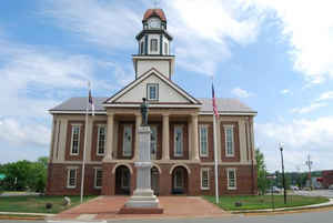
Chatham County is a county located in the Piedmont area of the state of North Carolina. Based on the 2010 census, the population was
63,505. Its county seat is Pittsboro.
Chatham County is part of the Durham-Chapel Hill, NC Metropolitan Statistical Area, which is also included in the Raleigh-Durham-Chapel Hill
Combined Statistical Area,
Etymology - Origin of County Name
It was named in honor of William Pitt, Earl of Chatham who was a most eloquent defender of the American cause in the English Parliament during the Revolution.
Demographics:
County QuickFacts: CensusBureau Quick Facts
Chatham County History
Chatham was formed in 1771 from Orange. The act became effective April 1, 1771. It was named in honor of William Pitt, Earl of Chatham who was a most eloquent defender of the American cause in the English Parliament during the Revolution. It is in the central section of the state and is bounded by Wake, Harnett, Lee, Moore, Randolph, Alamance, Orange and Durham counties. The present land area is 682.85 square miles and the 2000 population was 49,329. The act establishing the county provided for the courts to be held at the home of Stephen Poe. It also named commissioners to have a courthouse, prison and stocks erected. In 1778 a town was established on the land formerly belonging to Ambrose Edwards where the courthouse was. This town was named Chatham. Chatham Court House is mentioned in correspondence, 1776-1782. In 1785 a law establishing Pittsboro on Miles Scurlock 's land on which the courthouse stood was enacted. In 1787 an act was passed stating that the heirs of Scurlock would not allow a town to be established on their land. Therefore, the trustees of the town were advised to purchase land from William Petty adjoining the Scurlock tract and lay out a town. It was named Pittsboro in honor of William Pitt, the younger. In 1787 Pittsboro was made the county seat.
Geography: Land and Water
As reported by the Census Bureau, the county has a total area of 710 square miles (1,800 km2), of which 682 square miles (1,770 km2) is
land and 28 square miles (73 km2) (3.9%) is water.
The county lies totally within the Piedmont physiographic region. The topography of the county is generally gently rolling with several higher
hills rising above the general terrain.
The county lies within the Cape Fear River drainage basin. The Cape Fear River begins in the county near the community of Moncure, at the
confluence of the Haw River and the Deep River below Jordan Lake. B. Everett Jordan Lake, a major reservoir and flood-control lake, is located
within the New Hope River basin and lies mainly in eastern Chatham County. The lake is owned by the US Army Corps of Engineers and is
partially leased by the state of North Carolina as Jordan Lake State Recreation Area.
Much of the eastern part of the county lies within the Triassic Basin, a subregion of the Piedmont. Much of the bedrock in the county is
volcanic in origin and formed during the Triassic period (hence the name). The Triassic origins have led to the formation of coal deposits in
the southern part of the county. The Boren Clay Products Pit just north of Gulf in extreme southern Chatham County is a place where Triassic
flora fossils persist. The volcanic origins also led to the creation of high amounts of metamorphic-based rocks in the county. The county lies
on the Carolina Slate Belt. Soils in the county are mostly clay based and have a deep red color, as do most soils in the Piedmont. Groundwater
in the county is generally full of minerals and tends to be "hard" if not softened. Mineral-based water was the attraction at Mt. Vernon
Springs during the latter part of the 19th century and the early part of the 20th century.
Neighboring Counties
Bordering counties are as follows:
- Orange County - north
- Durham County - northeast
- Wake County - east
- Harnett County - southeast
- Lee County - south
- Moore County - southwest
- Randolph County - west
- Alamance County - northwest
Education
Chatham County contributes funds to, but does not govern, K-12 public education and the community college system. The Chatham County School
System is governed by its own elected board. There are three public high schools: Northwood in Pittsboro, Jordan-Matthews in Siler City, and
Chatham Central in Bear Creek.
Chatham is home to two charter schools - Woods Charter School[25] and Chatham Charter High School.
Woods Charter School is a grade K-12 public school. The school moved into a new fully equipped building on 160 Woodland Grove Lane outside
Pittsboro in August 2008. Woods ranked "top ten" on SAT scores in North Carolina.
Chatham Charter High School is a grade K-8 public school. The school is located on 2200 Hamp Stone Road in Siler City, NC.
Central Carolina Community College, which has two campuses in the county, is governed by its own appointed Board of Trustees.


Click Image to Enlarge
