


Click Image to Enlarge
North Carolina Counties
North Carolina is divided into one hundred counties. The establishment of North Carolina counties stretches over 240 years, beginning in 1668 with the creation of Albemarle County and ending with the 1911 creation of Avery and Hoke counties. Five counties have been divided or abolished altogether, the last being Dobbs County in 1791.Jones County, North Carolina
Jones County Education, Geography, and History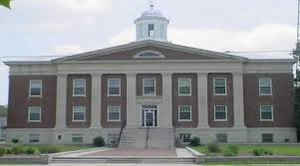
Jones County is a county located in the state of North Carolina. Based on the 2010 census, the population was 10,153, making it the
fifth-least populous county in North Carolina. Its county seat is Trenton.
Jones County is part of the New Bern, NC Micropolitan Statistical Area
Etymology - Origin of Jones County Name
It was named in honor of Willie Jones of Halifax who was one of the leaders of the Revolution, president of the Council of Safety and an opponent of the adoption of the Constitution of the United States.
Demographics:
County QuickFacts: CensusBureau Quick Facts
Jones County History
Jones was formed in 1779 from Craven. It was named in honor of Willie Jones of Halifax who was one of the leaders of the Revolution, president of the Council of Safety and an opponent of the adoption of the Constitution of the United States. It was due chiefly to his influence that the Convention of 1788 refused to ratify the Federal Constitution. It is in the eastern section of the State and is bounded by Craven, Carteret, Onslow, Duplin and Lenoir counties. The present land area is 471.88 square miles and the population in 2000 was 10,381. The first court was directed to be held at the home of Thomas Webber at Trent Bridge, and to continue there until the courthouse was built unless some other place was selected. In 1784 an act was passed authorizing a town by the name of Trenton to be laid out where the courthouse stood. Trenton is the county seat.
Geography: Land and Water
As reported by the Census Bureau, the county has a total area of 473 square miles (1,230 km2), of which 471 square miles (1,220 km2) is land and 2.5 square miles (6.5 km2) (0.5%) is water.
Neighboring Counties
Bordering counties are as follows:
- Craven County - northeast
- Carteret County - southeast
- Onslow County - south
- Duplin County - west
- Lenoir County - northwest
Education


Click Image to Enlarge
