


Click Image to Enlarge
North Carolina Counties
North Carolina is divided into one hundred counties. The establishment of North Carolina counties stretches over 240 years, beginning in 1668 with the creation of Albemarle County and ending with the 1911 creation of Avery and Hoke counties. Five counties have been divided or abolished altogether, the last being Dobbs County in 1791.Montgomery County, North Carolina
Montgomery County Education, Geography, and History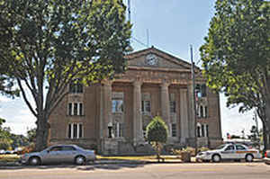
Montgomery County is a rural county located in the state of North Carolina. Based on the 2010 census, the population was 27,798. Its county seat is Troy.
Etymology - Origin of Montgomery County Name
It was named in honor of Richard Montgomery who, in 1775, lost his life at the battle of Quebec in the attempt to conquer Canada.
Demographics:
County QuickFacts: CensusBureau Quick Facts
Montgomery County History
Montgomery was formed in 1779 from Anson. It was named in honor of Richard Montgomery who, in 1775, lost his life at the battle of Quebec in the attempt to conquer Canada. It is in the south section of the State and is bounded by Moore, Richmond, Stanly, Davidson and Randolph counties. The present land area is 491.60 square miles and the 2000 population was 26,822. The act establishing the county specified that the first court should be held at the home of Henry Munger, and all subsequent courts were to be held where the justices of the peace decided until a courthouse could be erected. Another act was passed that same year naming commissioners to select fifty acres of land centrally located and erect a courthouse, prison and stocks. By 1783 there had developed dissatisfaction among many of the inhabitants as to the location the commissioners had selected. However, the Assembly that year authorized the courthouse to be constructed on the land purchased. The act provided for adequate ferries across the Yadkin and Uwharrie Rivers on the court, public and election days. In 1785 the General Assembly was petitioned to authorize the removal of the courthouse. In 1791 an act was passed directing that the center of the county be located by actual survey, at which place Stokes was to be established. The commissioners, however, failed to act, and in 1792 new commissioners were named. The courts were to be held at the home of Mark Kennet unless the justices decided on some other place more convenient. In that year, Henderson was established at the confluence of the Yadkin and Uwharrie Rivers. In 1795 the courthouse, on the land formerly belonging to James Tindall, was authorized to be sold. Tindallsville had been established in that year. In 1815 commissioners were named to locate the center of the county, purchase land, and erect a courthouse. They were authorized to sell the old courthouse and lot in the town of Henderson and apply the proceeds to the erection of the new buildings. In 1816 Laurenceville was named under the authority of a law enacted in 1815 establishing a town at the courthouse. In 1843 the courthouse was ordered to be moved from Laurenceville to the geographical center. Commissioners were named to locate the center, to acquire land, to lay out a town and erect the public buildings. In 1844 Troy was established as the county seat.
Geography: Land and Water
As reported by the Census Bureau, the county has a total area of 502 square miles (1,300 km2), of which 492 square miles (1,270 km2) is land and 10 square miles (26 km2) (2.0%) is water. It is situated in the heart of the Uwharrie National Forest.
Neighboring Counties
Bordering counties are as follows:
- Randolph County - northeast
- Moore County - east
- Richmond County - south
- Stanly County - west
- Davidson County - northwest
Education


Click Image to Enlarge
