


Click Image to Enlarge
North Carolina Counties
North Carolina is divided into one hundred counties. The establishment of North Carolina counties stretches over 240 years, beginning in 1668 with the creation of Albemarle County and ending with the 1911 creation of Avery and Hoke counties. Five counties have been divided or abolished altogether, the last being Dobbs County in 1791.Onslow County, North Carolina
Onslow County Education, Geography, and History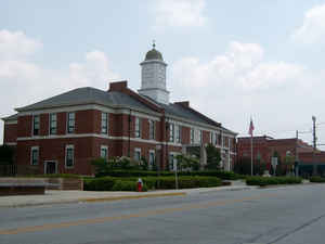
Onslow County is a county located in the state of North Carolina. Based on the 2010 census, the population was 177,772. Its county seat
is Jacksonville. The county was created in 1734 as Onslow Precinct and gained county status in 1739.
Onslow County comprises the Jacksonville, NC Metropolitan Statistical Area. The southern border is the coast of the Atlantic Ocean.
Etymology - Origin of Onslow County Name
t was named in honor of Arthur Onslow, who for more than thirty years was speaker of the House of Commons in the British Parliament.
Demographics:
County QuickFacts: CensusBureau Quick Facts
Onslow County History
Onslow was formed in 1731 from New Hanover. It was named in honor of Arthur Onslow, who for more than thirty years was speaker of the House of Commons in the British Parliament. It is in the south eastern section of the State and is bounded by the Atlantic Ocean and Pender, Duplin, Jones and Carteret counties. The present land area is 766.82 square miles and the 2000 population was 150,355. The act creating the county ordered the justices to select a site for a courthouse. The act also validated all acts of the court held in accordance with a commission, issued (November 23, 1731) by Governor Burrington for that purpose. From July, 1734, to January, 1735, court was held "at the court house on New River." In January, 1735, it was held at Joseph Howard's. In July of that year it was held at Christian Heidleberg's and from then until 1737 it was held at Joseph Howard's. After April 1737, it was held "at the courthouse on New River." The courthouse was burned between January and April 1744. Between April, 1744, and January, 1753, court was held "at Johnston on New River." Johnston was established in 1741. It is evident that for a while court was held in private homes, as James Foyle and Thomas Black were paid for allowing the court to sit at their homes. In January, 1753, the court met at Jonathan Melton's on North East New River, a storm having destroyed Johnston in September, 17O2. In July, 1757. court was held at the new courthouse at Wantland's Ferry on New River. In 1819 a new courthouse was authorized to be established within one-half mile from the old courthouse and on the same side of the river. In 1842 Jacksonville was authorized, but it was not laid out until after 1849. It is the county seat.
Geography: Land and Water
As reported by the Census Bureau, the county has a total area of 906 square miles (2,350 km2), of which 763 square miles (1,980 km2) is land and 143 square miles (370 km2) (16%) is water.
Neighboring Counties
Bordering counties are as follows:
- Jones County - north
- Carteret County - east
- Pender County - southwest
- Duplin County - northwest
Education


Click Image to Enlarge
