


Click Image to Enlarge
North Carolina Counties
North Carolina is divided into one hundred counties. The establishment of North Carolina counties stretches over 240 years, beginning in 1668 with the creation of Albemarle County and ending with the 1911 creation of Avery and Hoke counties. Five counties have been divided or abolished altogether, the last being Dobbs County in 1791.Yancey County, North Carolina
Yancey County Education, Geography, and History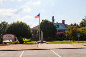
Yancey County is a county located in the state of North Carolina. Based on the 2010 census, the population was 17,818. Its county seat is
Burnsville.
This land was in inhabited by the Cherokee prior to European settlement. The Appalachian Mountains region belonged to the Cherokee Indians.
Etymology - Origin of Yancey County Name
It is named in honor of Bartlett Yancey, an eloquent orator, many times a member of the Legislature, speaker of the State Senate and member of Congress. He was also one of the earliest advocates of the public school system in North Carolina.
Demographics:
County QuickFacts: CensusBureau Quick Facts
Yancey County History
Yancey was formed in 1833 from Burke and Buncombe. It is named in honor of Bartlett Yancey, an eloquent orator, many times a member of the Legislature, speaker of the State Senate and member of Congress. He was also one of the earliest advocates of the public school system in North Carolina. It is in the western section of the State and is bounded by the state of Tennessee and Mitchell, McDowell, Buncombe and Madison counties. The present land area is 312.45 square miles and the 2000 population was 17,774. The act establishing the county named and authorized commissioners to purchase land, lay out a town, and erect a courthouse. Burnsville, named for Captain Otway Burns of Beaufort, North Carolina, who won fame in the War of 1812, is the county seat.
Geography: Land and Water
As reported by the Census Bureau, the county has a total area of 313 square miles (810 km2), of which 313 square miles (810 km2) is land and 0.6 square miles (1.6 km2) (0.2%) is water. Mount Mitchell at 6,684 feet (2,037 m), within Mount Mitchell State Park in Yancey County is the highest point in the United States east of the Mississippi River.
Neighboring Counties
Bordering counties are as follows:
- Mitchell County - northeast
- McDowell County - southeast
- Buncombe County - southwest
- Madison County - west
- Unicoi County, Tennessee - northwest
Education


Click Image to Enlarge
