Utah Counties
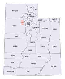
There are twenty-nine counties in the State of Utah. There were originally seven counties established under the provisional State of Deseret in 1849: Davis, Iron, Sanpete, Salt Lake, Tooele, Utah, and Weber. The Territory of Utah was created in 1851 with the first territorial legislature meeting from 1851-1852. The first legislature re-created the original counties from the State of Deseret under territorial law as well as establishing three additional counties: Juab, Millard, and Washington. All other counties were established between 1854 and 1894 by the Utah Territorial Legislature under territorial law except for the last two counties formed, Daggett and Duchesne.Beaver County, Utah
Beaver County Education, Geography, and History

Beaver County is a county located in the state of Utah. Based on the 2010 census, the population was 6,629. Its county seat and largest city is Beaver. The county was named for the abundance of beavers in the area.
Etymology - Origin of Beaver County Name
From the Beaver River, so called because of the many beaver once found there
Demographics:
County QuickFacts: CensusBureau Quick Facts
Beaver County History
The high peaks of the Tushar Range mark the eastern boundary of Beaver County. Delano Peak (12,173 feet) and Mount Belknap (12,139 feet) are among the highest mountains in the state. Most of the county, however, lies in the Basin and Range country typical of western Utah.Archaic and Sevier Fremont cultural sites have been found here, and in historic times the area was part of the Southern Paiutes' territory. Obsidian from the Mineral Mountains was used by the prehistoric inhabitants of much of central Utah to make stone tools.
In 1776 the Dominguez-Escalante expedition crossed the county near present Milford. Jedediah S. Smith (1826-27) and John C. Fremont (1844) had also traveled in the Beaver area before Albert Carrington explored it for the Mormons. The county was created in 1856, the same year Beaver City was founded.
The US Army built Fort Cameron in Beaver City in 1873, partly in response to Indian hostilities and partly to aid the 2nd District Court prosecute John D. Lee and others accused of participating in the Mountain Meadow Massacre. Lee's two trials were held in Beaver, and he was briefly imprisoned at the fort. The post, abandoned in 1883, became the site of Murdock Academy (1898-1922), a branch of Brigham Young Academy, forerunner of BYU.
Although the early settlers planted crops and grazed livestock, the county prospered in the 19th century because of a unique blend of mining, transportation, and trade in addition to farming. The Lincoln Mine northwest of Minersville may have been the first mine opened in Utah (1858). Lead was smelted and shipped to Salt Lake City to make ammunition. Many claims were staked and mining districts organized in the 1870s. The fabulous Horn Silver Mine was discovered in 1875 and the nearby town of Frisco, a wild boomtown, founded in 1876. The Horn attracted famous investors such as J. Pierpont Morgan.
The Frisco boom lasted only a decade. In the early 20th century the Cactus Mine, near the town of Newhouse, west of Frisco, produced gold, silver, copper, and other minerals.
Founded in 1870 by livestock growers, Milford became an important transportation center in May 1880 when the Utah Southern Railroad reached the town. A month later the line was extended to Frisco. Both ore and livestock were shipped to Salt Lake, and Milford was a forwarding point for freight. Horse and wagon teams carried freight from Milford to southern Utah, northern Arizona, and mining camps in Nevada. In Beaver City, the Beaver Woolen Mills, which operated from the 1870s to the turn of the century, found Frisco an important market for its products, especially blankets. The Beaver Co-op store, once one of the the largest mercantile establishments south of Salt Lake, opened in 1872 and profited from mining and transportation activity. In the 1980s the county's geothermal resources began to be tapped when an electric power generating plant using natural steam was built northeast of Milford. Recreation also adds to the economy.
*Source. Beehive History 14: Utah Counties. 1988. Utah State Historical Society, 300 Rio Grande, Salt Lake City, UT 84101-1182.
Geography
As reported by the Census Bureau, the county has a total area of 2,592 square miles (6,714 km2), of
which, 2,590 square miles (6,708 km2) of it is land and 2 square miles (6 km2) of it (0.09%) is water. The
Tushar Mountains lie on the eastern boundary of the county, reaching to 12,000 feet in elevation, and
providing water for the farming communities of Beaver and Manderfield. To the west, wide, barren desert
valleys typify the scenery, separated by mountains lightly forested with junipers.
Neighboring Counties
Bordering counties are as follows:
- Lincoln County, Nevada - (west)
- Millard County, Utah - (north)
- Iron County, Utah - (south)
- Sevier County, Utah - (east 1)
- Piute County, Utah - (east 2)
Education


