


Utah State Almanac: Facts and Figures
Quick Facts, Figures, and Overview of the State of Utah
Utah is one of the Mountain states of the US. Being the 13th biggest state in the United States, Utah constitutes a part of the western region of the country. The state covers a total area of 84,899 sq. miles and is bordered by Colorado, Arizona, Idaho, and Wyoming. Navajo Indians were referred to by the Apache as "Yuttahih" meaning "one that is higher up." Europeans misunderstood this term to refer to the tribes living higher in the mountains than the Navajo, the Utes, and the territory was called the land of the Utes, thus the name Utah.
Rich in natural resources, Utah has long been a leading producer of copper, gold, silver, lead, zinc, potassium salts, and molybdenum. Oil and natural gas have also become major products. Utah is the only state that produces gilsonite, a pure form of asphalt used in dark colored printing inks and paints, oil well drilling muds and cements, asphalt modifiers, foundry sands additives, and a wide variety of chemical products.
The state's top agricultural commodities include cattle and calves, dairy products, hay, greenhouse and nursery products, and hogs.
Utah Almanac: Fast Facts and Figures on the State of Utah |
|
|---|---|
| Official Name | Utah |
| Capital | Salt Lake City |
| Nicknames | Beehive State ...and more |
| Motto | Industry |
| Location Region |
40.77726 N, 111.92992 W Rocky Mountains Southwestern |
| Constitution Ratified | 1896 |
| Statehood | January 04, 1896 45th state |
| Population | 2,763,885 (2010) 27.18 sq. mi. 34th |
| Largest City (by population) |
10 largest cities (2010 est.):Salt Lake City,186,440; West Valley City, 129,480;Provo, 112,488; West Jordan, 103,712; Orem, 88,328; Sandy, 87,461; Ogden, 82,825; St. George, 72,897; Layton, 67,311; Taylorsville, 58,652 |
| Bordering States | North: Idaho East: Colorado South: Arizona West: Nevada |
| Major Industry | oil, natural gas, mining (coal, copper, iron ore, silver, gold), steel-making, farming (cattle, sheep, dairy products), tourism (especially skiing) |
| Major Rivers | Colorado River, Green River |
| Major Lakes | Great Salt Lake, Lake Powell, Utah Lake |
| Utah Counties | 29 Counties in Utah |
| Largest County (by population) |
Salt Lake County 1,029,655 (2010) 737 sq. mi. |
| Largest County (by area) |
San Juan County 7,821 sq. mi. |
| National parks | 5 |
| National monuments | 6 |
| State parks/forests | 40 |
| Electoral Votes | 5 |
| US Congress | 2 Senators; 3 Representatives |
| Time Zone | Mountain Standard Time |
| Zip Codes | NANPA |
| State Quick Facts | Census Bureau Quick Facts |
Utah Climate and Weather |
|
|---|---|
| Utah is known for low humidity and lots of sunshine.
The statewide average high temperature in July is near 80 degrees, while in January, a 30 degree high is average. Severe winter cold conditions
do occur in the upper elevations. Annual precipitation varies from less than five inches in Utah's Great Salt Lake desert to more than 50 inches in the northern mountain ranges. Snow frequently accumulates to depths of 10 feet or more at many Wasatch Mountain ski resorts. |
|
| Highest Temperature | 117 degrees July 5, 1985 - Saint George |
| Lowest Temperature | -69 degrees February 1, 1985 - Peter's Sink |
| Avg. Temp: High - Low |
93.2 degrees - 19.7 degrees |
Utah Points of Interest |
|
| The Great Salt Lake Desert area, Lake Powell and the Colorado River, Flaming Gorge Recreational Area, Bryce Canyon, Grand Staircase-Escalante National Monument, Monument Valley and Zion National Park. Utah is a great vacationland with 11,000 mi of fishing streams and 147,000 acres of lakes and reservoirs. Among the many tourist attractions are Arches, Bryce Canyon, Canyonlands, Capitol Reef, and Zion National Parks; Cedar Breaks, Dinosaur, Hovenweep, Natural Bridges, Rainbow Bridge, Timpanogos Cave and the Mormon Tabernacle in Salt Lake City. Salt Lake City hosted the 2002 Winter Olympics | |
Utah Highest, Lowest, and Mean Elevations (Feet) |
|
| Mean Elevation: 6,100 feet | |
|
Highest Point: Kings Peak: 13,528 feet
|
|
| Lowest Point: | Beaverdam Wash 2,000 feet |
Utah Land Area (Square Miles) |
|
| Geographic Center | In Sanpete County, 3 mi. N. of Manti Longitude: 111°41.1'W Latitude: 39°23.2'N |
| Total Area | 84,898.83 sq. mi. 13th |
| Land Area | 82,143.65 sq. mi. 96.76% |
| Water Area | 2,755.18 sq. mi. 3.24% |
| Forested Land Area | 29.9% |
| Dimensions (Length - Width) |
350 miles - 270 miles |
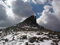 Kings Peak is the highest peak in
Utah. It is located in the High Uintas Wilderness Area, roughly two hours east of Salt Lake City. The Uintas are the only major mountain range in
the United States that run in an east - west direction. They feature several peaks over 4,000 meters. Kings Peak rises just south of the main Uintas
crest.
Kings Peak is the highest peak in
Utah. It is located in the High Uintas Wilderness Area, roughly two hours east of Salt Lake City. The Uintas are the only major mountain range in
the United States that run in an east - west direction. They feature several peaks over 4,000 meters. Kings Peak rises just south of the main Uintas
crest.
