


Click Image to Enlarge
Utah Counties
There are twenty-nine counties in the State of Utah. There were originally seven counties established under the provisional State of Deseret in 1849: Davis, Iron, Sanpete, Salt Lake, Tooele, Utah, and Weber. The Territory of Utah was created in 1851 with the first territorial legislature meeting from 1851-1852. The first legislature re-created the original counties from the State of Deseret under territorial law as well as establishing three additional counties: Juab, Millard, and Washington. All other counties were established between 1854 and 1894 by the Utah Territorial Legislature under territorial law except for the last two counties formed, Daggett and Duchesne.Box Elder County, Utah
Box Elder County Education, Geography, and History
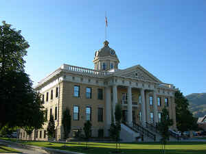
Box Elder County is a county located in the state of Utah. Based on the 2010 census, the population was 49,975. Its county seat and largest
city is Brigham City. The county was named for the box elder trees with which the county abounds.
Box Elder County lies on the north end of the Great Salt Lake, covering a large area north to the Idaho border and west to the Nevada border.
Included in this area are large tracts of barren desert, contrasted by high, forested mountains. The Wasatch Front lies along the
south-eastern border, where the main cities are found.
Box Elder County is part of the Ogden-Clearfield, UT Metropolitan Statistical Area, which is also included in the Salt Lake City-Provo-Orem,
UT Combined Statistical Area.
Etymology - Origin of Box Elder County Name
Box Elder County was named for the many box elder trees growing there
Demographics:
County QuickFacts: CensusBureau Quick Facts
Box Elder County History
Located in the upper northwest corner of the state, Box Elder County is part of the Great Basin and embraces a large land area extending from the west spur of the Wasatch Mountains to the Idaho border and westward to Nevada. It includes portions of the Great Salt Lake and the Great Salt Lake Desert. On the east are the lower course and deltas of the Bear River, the Malad River Valley, and the Promontory Mountains. Diverse in topography, the county contains rich farmlands as well as extensive marshlands at the mouth of the Bear River.Prehistoric hunters and gatherers roamed the area as early as 12,000 years ago, as did Indians of later periods. Danger, Promontory, and Hogup Caves, surrounding Great Salt Lake, and Shallow Shelter in the Grouse Creek Mountains are among the important excavated archaeological sites in Box Elder. During the 1820s and '30s fur trappers, including Peter Skene Ogden and Joseph R. Walker, explored the eastern and northern parts of the county. Permanent white settlement began in 1851 when a group of Mormons took up land in North Willow Creek (Willard). Brigham City was settled that same year and under Lorenzo Snow's direction became a model of Mormon cooperative enterprise. Because the land was already inhabited by Shoshone Indians, livestock raids and violent clashes between Indians and settlers were common until territorial Governor James Duane Doty negotiated the Treaty of Box Elder on July 30, 1863, in Brigham City. In 1856 the territorial legislature created Box Elder County from part of Weber County. Its boundaries were redefined in 1880 when the legislature divided the water and islands of the Great Salt Lake among Salt Lake, Davis, Weber, Tooele, and Box Elder counties. The most significant event in Box Elder history took place on May 10, 1869, at Promontory when the driving of the Golden Spike joined Central Pacific and the Union Pacific railroads to complete the transcontinental line. Corinne, a feisty, non-Mormon boomtown, became the freight transfer point for goods shipped to Idaho and Montana. In July 1870 Corinne residents spurred the founding of the Liberal party to oppose the Mormon People's party. Agriculture has always played an important role in the economy of Box Elder County. Some 43 percent of the county's land is used for agricultural purposes. Besides the standard crops of hay, grain, and alfalfa, sugar beets were also raised, starting in 1901, and kept two sugar factories, one in Garland and the other in Brigham City, operating for many years. Abundant fruit orchards and garden crops continue to contribute to the local economy. Since 1957, when Thiokol Chemical (now Morton-Thiokol) began its Brigham City operation, defense and aerospace have dominated the local economy and presently employ 5,000. Morton-Thiokol built the Minuteman missile and the space shuttle booster rockets.
*Source. Beehive History 14: Utah Counties. 1988. Utah State Historical Society, 300 Rio Grande, Salt Lake City, UT 84101-1182.
Geography: Land and Water
As reported by the Census Bureau, the county has a total area of 6,729 square miles (17,428 km2), of
which, 5,723 square miles (14,823 km2) of it is land and 1,006 square miles (2,605 km2) of it (14.95%) is water.
In the east lie the Wellsville Mountains, a branch of the Wasatch Range. In the west is a large, mostly
uninhabited desert area. The Great Salt Lake lies in the southern portion of the county. Interstate 15 runs
through the eastern portion merged with Interstate 84 past Brigham City. They split at Tremonton, with 84
heading northwest past Snowville into Idaho and 15 heading north past Plymouth and Portage into Idaho.
Neighboring Counties
Bordering counties are as follows:
- Cache County, Utah - (east)
- Weber County, Utah - (southeast)
- Tooele County, Utah - (south)
- Elko County, Nevada - (west)
- Cassia County, Idaho - (north)
- Oneida County, Idaho - (north)
Education
High
Bear River
Box Elder
Dale Young Community
Speciality schools
Early Learning Center
Independent Life Skills Center


Click Image to Enlarge
