Utah Counties
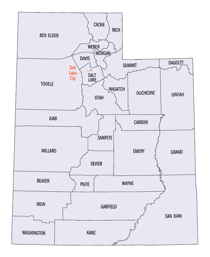
There are twenty-nine counties in the State of Utah. There were originally seven counties established under the provisional State of Deseret in 1849: Davis, Iron, Sanpete, Salt Lake, Tooele, Utah, and Weber. The Territory of Utah was created in 1851 with the first territorial legislature meeting from 1851-1852. The first legislature re-created the original counties from the State of Deseret under territorial law as well as establishing three additional counties: Juab, Millard, and Washington. All other counties were established between 1854 and 1894 by the Utah Territorial Legislature under territorial law except for the last two counties formed, Daggett and Duchesne.Davis County, Utah
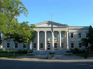
Davis County Education, Geography, and History

Davis County is a county located in the state of Utah. Based on the 2010 census, the population was 306,479, making it the third-most
populous county in Utah. Its county seat is Farmington, and its largest city is Layton. The county was created in 1850 and was named for
Daniel C. Davis, captain in the Mormon Battalion.
Davis County is part of the Ogden-Clearfield, UT Metropolitan Statistical Area as well as the Salt Lake City-Provo-Orem, UT Combined
Statistical Area.
Etymology - Origin of Davis County Name
after Captain Daniel C. Davis of the Mormon Battalion
Demographics:
County QuickFacts: CensusBureau Quick Facts
Davis County History
The dominant geographical features of
Davis County are the Wasatch Mountains on the east and the Great Salt lake on
the west. The mountains provide a source of water and help ensure a remarkably
uniform growing season. Not suprisingly, Davis County has always been a rich
agricultural area. It was attractive to people even before the time of permanent
white settlement. The resources of Davis County were likely used by prehistoric
populations beginning as early as 11,000 years ago.
The county's great agricultural potential was recognized quickly by the Mormon
pioneers, and during their first winter in Utah (1847-48) several of them moved
livestock into that area for winter forage. By 1850 a number of farms dotted the
south half of Davis County. By the 1870s the county was clearly the garden spot
of Utah. In addition to producing bounteous harvests and prize-winning
livestock, Davis County farmers led out boldly in experimenting with new crops,
such as sorghum and alfalfa, new equipment, such as headers and threshers, and
new methods, such as dry farming and irrigation management.
Economic prosperity, built on this farming base, followed Davis County into the
20th century. By 1910 the county sported two gristmills, two nurseries, eight
irrigation companies, and six canning factories. Five years later it also had a
sugar factory. A great variety of crops, fruit, and livestock was raised. New
schoolhouses, chapels, stores, and other structures popped up on the landscape.
Three railroads served the county's transportation needs.
During and immediately after World War II, significant changes began to appear
in Davis County. Farming, while still important, began to lose its position as
the economic leader. Defense installations it the Clearfield-Layton area, such
as Hill Air Force Base and the Naval Supply Depot, began to employ large numbers
of people. When the navy depot closed, industry and related enterprises
purchased the buildings in 1963 and developed the site into the Freeport Center,
a bustling manufacturing and distribution center. Suburbs to meet housing needs
developed around the Freeport-Hill hub and also in the southern part of the
county for people who commuted to Salt Lake City. Service industries, to support
this growing population, started to become prominent in the county's economic
make-up.
Although the state's smallest county in size, Davis is one of the fastest
growing in population. The number of residents doubled between 1910 and 1950,
doubled again by 1960, doubled again by 1975, and is expected to double again by
1996. It is presently Utah's third most populous county.
*Souirce: Beehive History 14:
Utah Counties. 1988. Utah State Historical Society, 300 Rio Grande, Salt Lake
City, UT 84101-1182
Geography: Land and Water
As reported by the Census Bureau, the county has a total area of 634 square miles (1,641 km2), of which, 304
square miles (789 km2) of it is land and 329 square miles (853 km2) of it (51.95%) is water. It has the least land
area of any county in Utah.
The county lies generally between the Great Salt Lake on the west and the Wasatch Range on the east, which rises to
a height of 9,707 ft (2,959 m) in the county at Thurston Peak. The Great Salt Lake in the west, which is surrounded
by marshland and mudflats, lies at an average elevation of approximately 4,200 ft (1,280 m), varying depending on
the water level, which can lead to drastic changes in the lake size due to its shallowness. Davis County includes
Antelope Island, which is the largest island in the lake. The entire island is a state park, designated to protect
natural scenery and especially wildlife on the island, which includes bighorn sheep, pronghorn antelope, and a bison
herd. The narrow, populated portion that lies between the Great Salt Lake and the Wasatch Range is a portion of the
Wasatch Front, which is very narrow at this point, complicating north-south transportation in the county.
Davis County borders Weber County on the north, Salt Lake County on the south, Tooele County on the west, Morgan
County on the east, and Box Elder County on the northwest corner. It should be noted, however, that Davis County
shares land borders with only Salt Lake, Morgan, and Weber counties; all other borders are water.
Davis County lies in a semiarid climate zone. Snow is frequent during winter, with up to 90 in (230 cm) annually on
high bench areas in the east and at least 60 inches (150 cm) on the valley floor. Annual precipitation averages
between 18 and 25 inches (450 to 650 mm) in the county, with spring being the wettest season and summer the driest.
Summers are hot, with several days each year averaging above 950F (350C). However, the humidity is low, making for
comparatively comfortable temperatures. In winter, temperatures sometimes drop below 00F (-180C), but rarely for
extended periods of time. Compared to Salt Lake County to the south, the weather in Davis County is extreme.
Lake-effect snows hit the southern portion of the county harder, and even in non-lake-effect storms, the lack of a
rain shadow in Davis County (much of Salt Lake County lies in the rain shadow of the Oquirrh Mountains) means that
storms often hit Davis County harder. In addition, canyon winds from the east can sometimes cause devastating wind
damage, and wind gusts above 100mph (160 km/h) have been reported. This occurs when a powerful high pressure system
situates itself over Wyoming, and is a common occurrence. Extreme wind events, however, have seemed to decline in
frequency in recent years.
Neighboring Counties
Bordering counties are as follows:
- Box Elder County, UT to the northwest
- Morgan County, UT to the east
- Salt Lake County, UT to the south
- Tooele County, UT to the west
- Weber County, UT to the north
Education
Public education in Davis County is served by the Davis School District. There are currently 59 elementary schools, 16 junior high schools,
8 high schools, and 3 alternative schools in the school district. The high schools are as follows:
Bountiful - Bountiful
Clearfield - Clearfield
Davis - Kaysville
Layton - Layton
Northridge - Layton
Syracuse - Syracuse
Viewmont - Bountiful
Woods Cross - Woods Cross
The Utah College of Applied Technology operates a campus in Kaysville known as the Davis Applied Technology College (DATC).
Utah State University owns and operates the Utah Botanical Center in Kaysville, which includes an education center. Weber State University
also operates a campus in Layton.


