


Click Image to Enlarge
Utah Counties
There are twenty-nine counties in the State of Utah. There were originally seven counties established under the provisional State of Deseret in 1849: Davis, Iron, Sanpete, Salt Lake, Tooele, Utah, and Weber. The Territory of Utah was created in 1851 with the first territorial legislature meeting from 1851-1852. The first legislature re-created the original counties from the State of Deseret under territorial law as well as establishing three additional counties: Juab, Millard, and Washington. All other counties were established between 1854 and 1894 by the Utah Territorial Legislature under territorial law except for the last two counties formed, Daggett and Duchesne.Piute County, Utah
Piute County Education, Geography, and History
Piute County is a county located in the state of Utah. Based on the 2010 census, the population was 1,556, making it the second-least populous county in Utah. The county seat is Junction, and the largest city is Circleville. The county was named for the Paiute tribe of Native Americans.
Etymology - Origin of Piute County Name
The county was named for the Paiute tribe of Native Americans.
Demographics:
County QuickFacts: CensusBureau Quick Facts
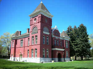
Piute County History
Piute County was split off from Beaver County in 1865. Its western boundary approximates
the crest of the Tushar Mountains with the highest peaks in the High Plateaus section of the
Colorado Plateau. Most of the population is concentrated in the Sevier River Valley. Grass
Valley (Otter Creek) lies between the Sevier Plateau in the center of the county and the Parker
Range on the eastern border.
Evidence of prehistoric inhabitants has been found in the caves of Kingston Canyon (now an
attractive local recreation area). The county has been occupied by both the Fremont and the
later Paiute Indians who were mainly gatherers and hunters of food and who produced beautiful
baskets for many uses and rabbit-skin clothing for winter protection. Circleville and Junction
were settled in 1864 by a group of Mormon pioneers from Ephraim. The Sevier Valley provided
good grazing, and livestock remains important to the economy. Wild hay, alfalfa, grain, and
pastures provide feed for the limited beef and dairy production. Earth-covered potato cellars
remain as evidence of a successful crop in an earlier era. The Piute School District employs
30 residents. Less obvious contributors to the local economy are a small group of retirees
in the larger towns. As in most of Utah's rural counties, "home" has a strong pull on the natives
while economic forces tend to push recent high school graduates toward the opportunities of
urban areas. Piute residents depend on nearby Richfield north on Highway 89 for major services.
Earth's riches once played a dominant role in the economy. A gold and silver boom in the Tushars
spawned such towns as Bullion, Kimberly, and Marysvale. The Ohio Mining District was organized
in 1868, and by 1872 Bullion Canyon boasted 5O buildings and hundreds of eager miners. Kimberly,
in the Gold Mountain District, developed around the rich Annie Laurie claim, located in 1891.
The completion of a Denver and Rio Grande Railroad branch line to Marysvale in 1900 linked
Piute's mines and farms to the marketplace. Later, lead, zinc, alunite, and uranium were significant
products. Piute's huge reserves of high-grade alunite ores were especially important during
World Wars I and II. Cyclical mining, now in a bust mode, could boom again. Recreational activities
also create some job opportunities. Piute and Otter Creek reservoirs provide good boating,
water skiing, and fishing. The Parker ranch just south of Circleville has become a tourist
attraction because of its association with outlaw Butch Cassidy.
*Source:. Beehive History 14: Utah Counties. 1988. Utah State Historical
Society, 300 Rio Grande, Salt Lake City, UT 84101-1182.
Geography: Land and Water
As reported by the Census Bureau, the county has a total area of 766 square miles (1,983
km2), of which, 758 square miles (1,963 km2) of it is land and 8 square miles (21 km2) of it
(1.04%) is water.
Neighboring Counties
Bordering counties are as follows:
- Sevier County, Utah - (north)
- Wayne County, Utah - (east)
- Garfield County, Utah - (south)
- Iron County, Utah - (southwest)
- Beaver County, Utah - (west)
Education


Click Image to Enlarge
