Utah Counties
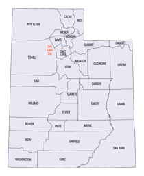
There are twenty-nine counties in the State of Utah. There were originally seven counties established under the provisional State of Deseret in 1849: Davis, Iron, Sanpete, Salt Lake, Tooele, Utah, and Weber. The Territory of Utah was created in 1851 with the first territorial legislature meeting from 1851-1852. The first legislature re-created the original counties from the State of Deseret under territorial law as well as establishing three additional counties: Juab, Millard, and Washington. All other counties were established between 1854 and 1894 by the Utah Territorial Legislature under territorial law except for the last two counties formed, Daggett and Duchesne.Tooele County, Utah
Tooele County Education, Geography, and History

Tooele County is a county located in the state of Utah. Based on the 2010 census, the population was 58,218. Its county seat and largest
city is Tooele. The county was created in 1850 and organized the following year.
Tooele County is part of the Salt Lake City, UT Metropolitan Statistical Area.
Etymology - Origin of Tooele County Name
probably from tule, a Spanish word of Aztec origin, meaning bulrush, a marsh plant
Demographics:
County QuickFacts: CensusBureau Quick Facts
Tooele County History
Tooele County is Basin and Range
country. Most of its towns lie in a broad valley between the mineral rich
Oquirrh Mountains on the eastern border and the Onaqui and Stansbury Mountains.
The Great Salt Lake Desert covers most of western Tooele, except the southwest
corner where the Deep Creek Mountains rise.
Prehistoric Indian sites have been discovered in the county, but the unique
story is the survival of the Goshutes, a branch of the Western Shoshone, who
claim this harsh environment as their ancestral homeland. Their ingenious use of
the limited plant and animal resources of the area amazed the first white
travelers. The Goshute Reservation is in Skull Valley.Tuilla, as it was
originally spelled, was one of six counties created in January 1850. Its
boundaries were changed a number of times before it achieved its present size as
the state's second largest county. The Mormons herded livestock in Tooele Valley
before permanent settlement began in 1849. The early settlers farmed; built
gristmills and sawmills; and manufactured salt, charcoal, lime, adobes, and
woolen products. Large sheep and cattle herds were developed, and hay and grain
became important crops. But mining and smelting, not agriculture led the
county's growth from the 1860s to World War II. The Rush Valley Mining District,
organized in 1864 by soldiers from Fort Douglas, included all of the western
Oquirrhs. More than 500 mining claims were located during the first year. Of the
mining towns founded in Tooele County, Ophir and Mercur became the most
important. Ophir boomed in the l870s with an estimated population of 6,000 and
mines that produced millions in silver, lead, zinc, and gold. Mercur endured
several boom and bust cycles and two major fires. With a population estimated as
high as 10,000 it flirted briefly with the idea of taking the county seat from
Tooele City. The International Smelting and Refining Company's smelter, built
east of Tooele City in 1910, processed ore carried by aerial tramway from the
Bingham mine for some 60 years. The plant attracted many immigrant workers,
diversifying Tooele's ethnic and religious mix. The Tooele Valley Railroad,
completed in 1909, served the smelter and created jobs.Military installations
built during World War II boosted the county's population and continue to pump
millions of dollars into the local economy. Wendover Air Base (now closed) near
the Nevada border became an important site for bomber training with almost
20,000 military and civilian personnel. Tooele Ordnance Depot (now Tooele Army
Depot, TAD), built in 1942 on a huge tract of land south of Tooele City served
as a major supply storage, and repair center employing almost 2,000 civilians in
1944. Activity at TAD peaked during the Korean War and again during the Vietnam
conflict. Dugway Proving Grounds, a chemical and biological warfare test center
built in the 1940s, became controversial in the 1970s when a large number of
sheep in the area were killed, presumably a result of testing. Today most of
western Tooele County is reserved for military use.
*Sources: Beehive History 14: Utah Counties. 1988. Utah State Historical
Society, 300 Rio Grande, Salt Lake City, UT 84101-1182.
Geography: Land and Water
Covering vast amounts of the Great Salt Lake desert west of Salt Lake Valley, Tooele county is the second largest
county in Utah and among the driest.
As reported by the Census Bureau, the county has a total area of 7,287 square miles (18,874 km2), of which, 6,930
square miles (17,950 km2) of it is land and 357 square miles (924 km2) of it (4.90%) is water.
Neighboring Counties
Bordering counties are as follows:
- Box Elder County, Utah - (north)
- Weber County, Utah - (northeast touch)
- Davis County, Utah - (east 1)
- Salt Lake County, Utah - (east 2)
- Utah County, Utah - (east 3)
- Juab County, Utah - (south)
- White Pine County, Nevada - (southwest)
- Elko County, Nevada - (west)
Education


