


Click Image to Enlarge
Alabama Counties
Alabama currently has sixty-seven counties. The oldest county, Washington, was created on June 4, 1800, when what is now Alabama was then part of the Mississippi Territory. The newest county is Houston, created on February 9, 1903.Coffee County, Alabama History
Coffee County Education, Geography, and History
 Coffee
County is a county of the state of Alabama. Based on the 2010 census, the population was 49,948. Coffee County
was created on December 29, 1841, from what had been
part of Dale County. The county seat
is Elba. The county is named in honor of General John
Coffee.
Coffee
County is a county of the state of Alabama. Based on the 2010 census, the population was 49,948. Coffee County
was created on December 29, 1841, from what had been
part of Dale County. The county seat
is Elba. The county is named in honor of General John
Coffee.
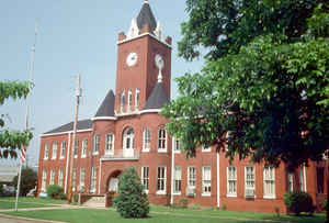
Coffee County comprises the Enterprise, AL Micropolitan Statistical Area, which is also included in the Dothan-Enterprise-Ozark, AL Combined Statistical Area. The Coffee County Courthouse is located in Elba.
Etymology - Origin of Coffee County Name
Coffee County was named for General John Coffee, a hero of the Creek War of 1813-14.
Demographics:
County QuickFacts: CensusBureau Quick Facts
Coffee County History
Coffee County, Alabama
Coffee county was formed by the Alabama legislature on December 29, 1841 from what had been part of Dale County. It was named for General John Coffee, a hero of the Creek War of 1813-14. Coffee County is located in the southeastern part of the state and is bordered on the north by Pike County, on the east by Dale County, on the south by Geneva County, and on the west by Covington and Crenshaw counties. It encompasses 680 square miles. The first county seat was at Wellborn. The county courthouse was destroyed by fire in 1851, and the following year the legislature authorized an election to be held to select another site. The town of Elba, then called Bentonville, was chosen. Other towns and communities include Enterprise, Kinston, and New Brockton.
Geography: Land and Water
As reported by the Census Bureau, the county has a total area of 680 square miles (1,800 km2), of which 679 square miles (1,760 km2) is land and 1.5 square miles (3.9 km2) (0.2%) is water.
The Pea River, the largest tributary of the Choctawhatchee River, runs from north to south in the center of Coffee county. Several smaller tributaries of the Pea River, including Double Bridges, Tight Eye, Beaverdam, Whitewater, Big, and Steep Head creeks, intersect the county.
Neighboring Counties
Bordering counties are as follows:
- North: Pike County
- East: Dale County
- Southeast: Geneva County
- Southwest: Covington County
- Northwest: Crenshaw County
In popular culture
The county is referred to in Joe David Brown's 1971 novel Addie Pray, which inspired the movie Paper Moon.
Education


Click Image to Enlarge
