


Alabama State Almanac: Facts and Figures
Quick Facts, Figures, and Overview of the State of Alabama
Alabama, one of the East South Central states of the US. It is bordered by Tennessee, Georgia, Florida and the Gulf of Mexico and Mississippi. Origin of the name Alabama is thought to come from a combination of two Choctaw words; Alba and Amo. In Choctaw, "Alba" means vegetation, herbs, plants and "Amo" means gatherer or picker.
Located in the "Heart of Dixie," Alabama was once the historical land of Indians, the Spanish, the French and the English. It modern history includes a significant presence in the iron and steel industries, as well as being one of the leaders of the US Space Age - as a cutting-edge center for space vehicle research. Alabama's rich resources made the state attractive to new industry. Tuscaloosa is known for electronics manufacturing, and Birmingham is home to cutting-edge biomedical research and engineering, and to telecommunications firms. New car manufacturing industries continued to come to the state. In 1989, the manufacturing sector of the state's economy employed 24 percent of Alabama's total workforce.
Alabama Almanac: Facts About Alabama |
||
|---|---|---|
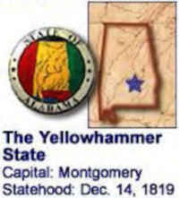
| Official Name | Alabama | |
| Capital | Montgomery | |
| Nicknames | Yellowhammer State ... and more | |
| Motto | Audemus jua nostra defendere - (We dare defend our rights) | |
| Location & Region | 32.35440 N, 086.28428 W Southern Appalachia |
|
| Constitution Ratified | 1901 | |
| Statehood | December 14, 1819 22nd State |
|
| Population | 4,779,736 (2010) 87.6 sq. mi. 23rd |
|
| Largest City (by population) |
10 largest cities (2010): Birmingham, 212,237; Montgomery, 205,764; Mobile, 195,111; Huntsville, 180,105; Tuscaloosa, 90,468; Hoover, 81,619; Dothan, 65,496; Decatur, 55,683; Auburn, 53,380; Madison, 42,938 | |
| Bordering States | North: Tennessee East: Georgia (Chattahoochee River forms much of the Eastern boundary) South: Florida and the Gulf of Mexico West: Mississippi Coastline: 53 mi. |
|
| Major Industries | agriculture (cotton, corn, peanuts, soybeans, poultry, and livestock), hydroelectric power, mining (coal, limestone, iron ore), steel-making | |
| Major Rivers | Tombigbee River, Alabama River, Tennessee River, Chattahoochee River | |
| Major Lakes | Guntersville Lake, Wilson Lake, Martin Lake, West Point Lake, Lewis Smith Lake | |
| Alabama Counties | 67 Counties in Alabama | |
| Largest County (by population) |
Jefferson County 657,229 (2005) 1,113 sq. mi. |
|
| Largest County (by area) |
Baldwin County 1,596 sq. mi. |
|
| State forests | 21 (48,000 ac.) | |
| State parks | 22( 45,614 ac.) | |
| Electoral Votes | 9 | |
| US Congress | 2 Senators; 7 Representatives | |
| Time Zone | Central Standard Time | |
| Zip Codes | NANPA | |
| State Quick Facts | Census Bureau Quick Facts | |
Alabama Climate and Weather |
|
|---|---|
|
The majority of Alabama's days are warm and sunny. Rainfall
across the state is lowest in October and highest in March. Spring comes early, with a brilliant palette of colors and temperatures around 60 degrees
Fahrenheit (15 degrees Celsius) daily by March. Summer days average in the 80s F (mid-20s C), with periods of heat in the 90s F (32 C) peaking in
July. |
|
| Highest Temperature | 112 degrees Sept. 5, 1925 - Centerville |
| Lowest Temperature | -27 degrees Jan. 30, 1996 - New Market |
| Avg. Temp: High - Low |
91.5 degrees 31 degrees |
Alabama Points of Interest |
|
| Alabama offers a wide variety of quality family attractions, including sandy beaches along its Gulf of Mexico coastline, forested mountain campsites and trails, and great fishing lakes. In addition, some of its favorite attractions include NASA's Space Center in Huntsville, numerous Civil War battlefields, the USS Alabama battleship moored near Mobile, the NASCAR Super Speedway in Talladega, and the historic cities of Birmingham and Montgomery, and of course, Alabama's famous "Southern Hospitality." | |
Alabama Highest, Lowest, & Mean Elevations (Feet) |
|
| Mean Elevation: 500 feet | |
| Highest Point: Cheaha Mountain: Talladega National Forest 2,407 feet.
|
|
| Lowest Point: | Gulf of Mexico Sea level |
Alabama Land Area (Square Miles) |
|
| Geographic Center | In Chilton Co., 12 mi. SW of Clanton Latitude: 32°50.5'N Longitude: 86°38.0'W |
| Area | 52,419.02 sq. miles 30th |
| Land Area | 50,744.00 sq. miles [Alabama is the 30th biggest state in the USA] 96.81% |
| Water Area | 1,675.01 sq. miles 3.19% |
| Forested Land Area | 67.6% |
| Dimensions (Length - Width) |
330 miles - 190 miles |
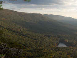 The Creek Indians
named it Cheaha meaning "high place" - an appropriate name, as Cheaha Mountain in Lineville, Alabama is the highest point in Alabama, at
2,407 feet above sea level. Visitors can overlook the valley from the park's restaurant.
The Creek Indians
named it Cheaha meaning "high place" - an appropriate name, as Cheaha Mountain in Lineville, Alabama is the highest point in Alabama, at
2,407 feet above sea level. Visitors can overlook the valley from the park's restaurant.Autauga, Baldwin, Barbour, Bibb, Blount, Bullock, Butler, Calhoun, Chambers, Cherokee, Chilton, Choctaw, Clarke, Clay, Cleburne, Coffee, Colbert, Conecuh, Coosa, Covington, Crenshaw, Cullman, Dale, Dallas, DeKalb, Elmore, Escambia, Etowah, Fayette, Franklin, Geneva, Greene, Hale, Henry, Houston, Jackson, Jefferson, Lamar, Lauderdale, Lawrence, Lee, Limestone, Lowndes, Macon, Madison, Marengo, Marion, Marshall, Mobile, Monroe, Montgomery, Morgan, Perry, Pickens, Pike, Randolph, Russell, Shelby, St. Clair, Sumter, Talladega, Tallapoosa, Tuscaloosa, Walker, Washington, Wilcox, Winston

