


Click Image to Enlarge
Alabama Counties
Alabama currently has sixty-seven counties. The oldest county, Washington, was created on June 4, 1800, when what is now Alabama was then part of the Mississippi Territory. The newest county is Houston, created on February 9, 1903.Randolph County, Alabama History
Randolph County Education, Geography, and History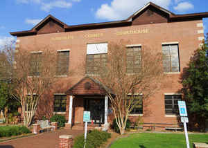
Randolph County is a county of the state of Alabama. Based on the 2010 census, the population was 22,913. Randolph County was created on December 18, 1832 from former Creek Indian territory by the Creek Cession of 1832. The county seat is Wedowee. Randolph county is named in honor of John Randolph, a member of the United States Senate from Virginia.
Etymology - Origin of Randolph County Name
The county is named for John Randolph, a former Virginia statesman.
Demographics:
County QuickFacts: CensusBureau Quick Facts
Randolph County History
Randolph County, Alabama
Randolph
county was formed by an act of the Alabama General Assembly on December
18, 1832 from former Creek Indian territory. The county is located in the eastern-central part of the state, in the Piedmont plateau
and encompasses 585 square miles.
Randolph county is named for John Randolph, a former Virginia statesman. The county seat was established in Wedowee in 1834-35. Other towns of note include Roanoke, Rock Mills and Wadley.
The first European-American settlers noted that the county was ideally located between three major cities of Atlanta, Birmingham and
Montgomery. They said that the county had an abundance of the "purest and coldest freestone water in the world." The area was also noted for
its gentle rolling hills. The first county seat for Randolph County was established in 1833 at Hedgeman Triplett's Ferry on the west bank of
the Big Tallapoosa River, about 10 miles (16 km) west of Wedowee, Alabama.
In 1835 (2 years later), the county seat was moved by the commissioners to nearby Wedowee. This city lies in the center of Randolph County, on
a fork of the Little Tallapoosa River. Wedowee was named after a Creek tribal chief "Wah-wah-nee" (or "Wah-dow-wee") whose village stood near
the present site of the town. The county was developed for agriculture, specifically cotton plantations, which were worked by African-American
slaves brought by migrants to the region or transported during the domestic slave trade. It was part of what was known as the Black Belt of
Alabama, an area of plantation development in the uplands, where short-staple cotton was cultivated. In 2010 some 20 percent of the population
was African American, reflecting this history of agriculture based on slavery.
Randolph County was a prohibition or dry county until 2012 when the citizens of Randolph County voted to repeal prohibition.
Geography: Land and Water
As reported by the Census Bureau, the county has a total area of 584 square miles (1,510 km2), of which 581 square miles (1,500 km2) is land and 3.6 square miles (9.3 km2) (0.6%) is water.
The Tallapoosa River runs through the county and is home to 120 species of fish and 31 species of mussel. The R. L. Harris Dam forms the 10,000-acre Lake Wedowee on the Upper Tallapoosa. Both the Upper and Middle Tallapoosa tributaries offer a range of recreational opportunities and scenic views in Randolph County. A few tributaries of the Chattahoochee River wind their way through the eastern half of the county as well.
Neighboring Counties
Bordering counties are as follows:
- North: Cleburne County
- Northeast: Carroll County, Ga.
- East: Heard County, Ga.
- Southeast: Troup County, Ga.
- South: Chambers County
- Southwest: Tallapoosa County
- West: Clay County
Places of interest
Randolph County is home to Lake Wedowee, a section of the Tallapoosa River.
Education


Click Image to Enlarge
