


Click Image to Enlarge
California Counties
The state of California is divided into fifty-eight counties. On January 4, 1850, the California constitutional committee recommended the formation of 18 counties. They were Benicia, Butte, Fremont, Los Angeles, Mariposa, Monterey, Mount Diablo, Oro, Redding, Sacramento, San Diego, San Francisco, San Joaquin, San Jose, San Luis Obispo, Santa Barbara, Sonoma, and Sutter. The last California county to have been established is Imperial County in 1907.San Benito County, California
San Benito County Education, Geography, and History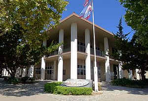
San Benito County is a county located in the Coast Range Mountains of the state of California. Based on the 2010 census, the
population was 55,269. The county
seat is Hollister. San Benito was created
February 12, 1874. The county is named after
San Benito Valley. Crespi, in his expedition in 1772, named a small
river in honor of San Benidicto (Saint Benedict), the patron saint
of the married, and it is from the contraction of this name that the
county took its name.
San Benito County is included in the San Jose-Sunnyvale-Santa Clara, CA Metropolitan Statistical Area, which is also included in the San
Jose-San Francisco-Oakland, CA Combined Statistical Area.
Etymology - Origin of San Benito County Name
The county is named after San Benito Valley. In his expedition in 1772, Crespi named a small river in honor of San Benidicto (Saint Benedict), the patron saint of the married, and it is from the contraction of this name that the county took its name.
Demographics:
County QuickFacts: CensusBureau Quick Facts
San Benito County History
San Benito County was formed from parts of Monterey County in 1874.
The settlement of the extensive and fertile San Benito valley and the valleys tributary
thereto, which were separated from the rest of Monterey county by the Gabilan
range of mountains, developed interests which centered in the
new communities, and out of which grew a
desire by the people to manage for themselves their own local affairs. The first attempt to divide
Monterey county, by having San Benito set oft by itself as a separate political division, was made in
the legislature of 1869 --'70; but the opposition interposed by the resident portion of the present old
county caused the movement to fail at this time. However, it continued to gain strength from many
and legitimate causes. The contest became a very heated one for the time being, swallowing up all other
issues. The people living east of the Gabilan insisted that they were entitled to a division, and they
were almost unanimously determined to have it. The election of a representative in the legislature
turned on this one issue. The question was division or no division, Republicans and Democrats forgetting
their party affiliations. But though the "new-county" people were still in the minority, they did not
give up the fight. They returned again to the charge in the next election, and won by a small majority.
The contest was carried to the Assembly and then to the Senate, in each of which houses the divisionists
won, and then to the governor, who after some hesitation signed the bill, and thus, finally, in March
1874, the act creating the new county became a law. By this act the governor was authorized and directed
to appoint five commissioners who were charged with the organization of the new county. The names of the
commissioners appointed were: T. S. Hawkins, Jesse Whitton, Mark Pomeroy, John Breen and H. M. Hayes.
This commission met at the town of Hollister, February 18, 1874, and organized by electing John Breen as
president, and H. M. Hayes as secretary. The new county was subdivided into four townships, viz.:
Hollister, San Juan, San Benito and Paicines. and three supervisorial districts, numbered one, two and
three. District number one, comprised Hollister township; number two, San Juan township; and number
three, San Benito and Paicines townships. The new officers were to be appointed by the governor or
filled by special election. James F. Breen, who had resigned the judgeship of Monterey county was
appointed by the governor to the same position in San Benito county, while the commissioners, under
provisions of the organic act, ordered a special election on the 26th day of March, 1874, whereat the
required county officers were to be chosen, and the county seat was to be permanently located by popular
vote.
The history of San Benito
County - Sections excerpted from A Memorial and Biographical History of the Coast Counties of
Central California by Henry D. Barrows and Luther A. Ingersoll, and published by The Lewis Publishing
Company in 1893.
Geography: Land and Water
As reported by the Census Bureau, the county has a total area of 1,391 square miles (3,602 km2),
of which, 1,389 square miles (3,598 km2) of it is land and 2 square miles (4 km2) of it (0.12%) is
water.
San Benito County covers approximately 1,396 square miles ranging in elevation from near sea level to
over 5,000 feet, has a population of over 56,000, and is bordered to the north by Santa Clara and Santa
Cruz counties, by Merced and Fresno counties to the east, and by Monterey County on the west and south.
Hollister, the county seat, is approximately 95 miles south of San Francisco, 45 miles inland from
Monterey, and 300 miles north of Los Angeles.
Neighboring Counties
Bordering counties are as follows:
- Northeast: Merced County
- East: Fresno County
- Southwest: Monterey County
- Northwest: Santa Cruz County; Santa Clara County
Education


Click Image to Enlarge
