


Click Image to Enlarge
California Counties
The state of California is divided into fifty-eight counties. On January 4, 1850, the California constitutional committee recommended the formation of 18 counties. They were Benicia, Butte, Fremont, Los Angeles, Mariposa, Monterey, Mount Diablo, Oro, Redding, Sacramento, San Diego, San Francisco, San Joaquin, San Jose, San Luis Obispo, Santa Barbara, Sonoma, and Sutter. The last California county to have been established is Imperial County in 1907.San Mateo County, California
San Mateo County Education, Geography, and History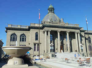
San Mateo County is a county located in the state of California. Based on the 2010 census, the
population was 718,451. The county
seat
is Redwood City. The county was created April 19,
1856. The county is named for the Spanish name for
Saint Matthew.
San Mateo County is included in the San Francisco-Oakland-Hayward, CA Metropolitan Statistical Area, and is part of the San Francisco Bay
Area, the nine counties bordering San Francisco Bay.
Etymology - Origin of San Mateo County Name
The county bears the Spanish name for Saint Matthew. As a place
name, St. Matthew appears as early as 1776, and the arroyo, the point and the
settlement at the unofficial San Mateo Mission are all so designated on the
early maps. Until about 1850, the name appeared as San Matheo.
Demographics:
County QuickFacts: CensusBureau Quick Facts
San Mateo County History
San Mateo County (pronounced /ˌsæn məˈteɪoʊ/ "san muh-TAY-o") (Spanish for: St. Matthew County) is a county located in the San Francisco Bay Area of the state of California. The county covers most of the San Francisco Peninsula just south of San Francisco, and north of Santa Clara County. San Francisco International Airport is located at the northern end of the county, and Silicon Valley begins at the southern end. San Mateo County was formed from parts of San Francisco County and Santa Cruz County in 1856. The county seat is Redwood City.
Because of the growth of the county that in the spring of 1856 the Hon. Horace Hawes
introduced in the State Senate a bill entitled: "An act to repeal the several charters of the City and
County of San Francisco, and to consolidate the government thereof." This became a law and received the
governor's approval on April 19, of the same year.
The borders of the new county were identical with those of the southern portion of the County of San
Francisco, up to the present northerly line where the two counties were cut apart.
A year later, because of troubling irregularities found in the consolidating act, Senator T. G. Phelps,
a resident of San Mateo County, introduced a bill to effect the proper organization of the county.
The bill
passed April 18, 1857, which date properly marks the legal organization of the county.
This act defined the southern boundary of the county, from a point in the middle of San
Francisco Bay opposite the mouth of San Francisquito Creek; on to and up the middle of said creek,
following the middle of the south branch to its source in the Santa Cruz Mountains; due
west to the Pacific Ocean and three miles within.
Another section of this Act provided that Redwood City should remain the county seat until
otherwise provided by law. Eleven years later this southern boundary was expanded southward and made to
include ninety thousand acres or 140 square miles of additional territory. This was acquired from Santa
Cruz County in March, 1868, by "An Act to fix and define the boundary line between the Counties of San
Mateo and Santa Cruz." This new territory included Pescadero and Pigeon Point.
During the early years following the consolidation of county government, the choice of the county seat
wavered between three places,- Belmont, Redwood City and San Mateo.
The county's first election held in May, 1856 at which frauds were
committed on an
unorganized and solely unprotected community by thugs and ballot stuffers from San Francisco; Belmont
was declared the county seat, and the government of the county was set up at that place.
The county court held at Belmont with judge Fox presiding, declared the May election
illegal, and the archives of the government were removed from that place to Redwood City, where Diller's
store building became the temporary Court House.
On February 27, 1858, the county through the board of commissioners accepted the offer of Mr. S. M.
Mezes, acting as agent for the Arguellos, owners of the Pulgas Grant, donating a block of land in
Redwood City for the site of the court house and jail.
Throughout this time the county seat advocates for other locations had not
slowed down, and the question was
brought to an issue in an election called for May 1861, which resulted in favor of Redwood City by a
vote of six hundred and fifty-six against three hundred and sixty-four for San Mateo and one for
Belmont.
Twelve years later another election was held, December 9, 1873, on this same subject, when money was
spent freely and active efforts made by the respective partisans of the rival towns. The election
returns stood- seven hundred and three votes for Redwood City, and six hundred and ninety-three for San
Mateo, thus leaving a majority still in favor of Redwood City.
Not being discouraged by defeat, San Mateo was inspired to further efforts by this
outstanding
showing and in five months succeeded in calling another election at which their city was returned the
victor with an overwhelming majority of two hundred and sixty votes.
Because of the alleged irregularities connected with this election, its legality was contested in the
Supreme Court. On February 24, 1875 this court decided in favor of Redwood City, which thenceforth has
remained the county seat.
More at
History of San Mateo County
by Philip W. Alexander, 1916
Geography: Land and Water
As reported by the Census Bureau, the county has a total area of 741 sq mi (1,919 km2). 449 sq mi (1,163 km2) of it is land and 292 sq mi (756 km2) of it (39.40%) is water.
A number of bayside
watercourses drain the eastern part of the county including San Bruno Creek and Colma Creek. Streams
draining the western county include Frenchmans Creek, Pilarcitos Creek, Naples Creek, Arroyo de en Medio,
and Denniston Creek.
Neighboring Counties
Bordering counties are as follows:
- North: San Francisco city & county
- Northeast: Alameda County
- East: San Francisco Bay; Santa Clara County
- Southeast: Santa Cruz County
- West: North Pacific Ocean
Education
The people of San Mateo county may use the services of the Peninsula Library System and its dozens of branches, bookmobile and
Library-a-Go-Go machine at the Millbrae BART/Caltrain station.
The county is broken up into several public school districts in addition to the local Catholic diocese and many other private parochial
and secular schools. The San Mateo County Board of Education oversees early education, special education, and the court and community
schools program in the county, as well as serves as an appeal board for the adjudication of expulsion appeals, interdistrict attendance
appeals, and Charter Schools.
Some students in San Mateo County's public schools attend outdoor education in La Honda. San Mateo Outdoor Education is a residential
school that teaches major concepts of ecology via exploration of forest, pond, garden, tidepool, wetland, and sandy shore habitats. The
center's mascot is the banana slug, a large yellow gastropod. The school uses songs from the famous Banana Slug String Band.


Click Image to Enlarge
