


Click Image to Enlarge
Kansas Counties
Kansas has one hundred and five counties. Originally 33 counties were organized by the Territorial Legislature in 1855. The Chase County Courthouse in Cottonwood Falls, Kansas was built in 1873 and is the oldest operating courthouse in Kansas. As of January 1, 2009 Greeley County and the city of Tribune unified to form the Unified Government of Greeley County..Grant County, Kansas
Grant County Education, Geography, and History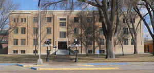
Grant County is a county located in the state of Kansas. Based on the 2010 census, the county population was 7,829. Grant County was created on March 20, 1873. The county seat is Ulysses. The county is named in honor of Ulysses Simpson Grant (1822-1885), Union general in the Civil War and president of the United States.
Etymology - Origin of Grant County Name
The county is named in honor of General Ulysses S. Grant, Union general in the Civil War and president of the United States.
Demographics:
County QuickFacts: CensusBureau Quick Facts
Grant County History
Grant County, in the southwestern part of the state, is the second north from the Oklahoma line and the second east from Colorado. It was created in 1887 out of Finney county territory, by act of the legislature which fixed its boundaries as follows: "Commencing at the intersection of the east
line of range 35 west with the north line of township 27 south; thence south along range line to where it intersects the 6th standard parallel; thence west along the 6th standard parallel to where it is intersected by the east line of range 39 west; thence north along said range line to its
intersection with the north line of township 27 south; thence east to the place of beginning."
In compliance with a petition from the citizens the governor appointed T. J. Jackson to take the census. He made his report in Aug., 1887, which showed that there were 2,716 inhabitants, 653 of whom were householders, and $534,756 worth of taxable property. There were three candidates for the county
seat, Ulysses, Cincinnati and Surprise, the latter being a little town 4 miles northwest of Ulysses and 2 miles north of Cincinnati. The governor's proclamation was not made until June, 1888. It named Ulysses as the temporary county seat
The Cimarron cutoff on the Santa Fe trail passed through Grant County, turned south and crossed the path of modern highway US 160 just east of Ulysses. It continued south and crossed the Cimarron in the southern part of the county.
The county was named for Ulysses Grant, Union general in the Civil War and president of the United States. As in many other Kansas counties, the struggle to determine which town would become county seat was fierce.
"At the height of the county seat contest between Ulysses and Appomattox in
1888, Ulysses boasted a population of 2,000 and supported twelve restaurants,
four hotels, several other businesses, six gambling houses, and twelve saloons .
. . "
The battle was so expensive that the town of Ulysses went deeply into debt. In 1909, the buildings of the town were moved three miles to the present site to prevent foreclosure at the old townsite. Only a masonry school was left behind for the East Coast bondholders.
Geography: Land and Water
As reported by the Census Bureau, the county has a total area of 575 square miles (1,490 km2), of which 575 square miles (1,490 km2) is land and 0.3 square miles (0.78 km2) (0.06%) is water.
Grant county is located in west Kansas. The land in Grant county is prairie.
The north fork of the Cimarron river flows in a northeast direction to the center,
then southeast across the eastern boundary. The south fork of the same river flows east across the southern part, joining
the north fork near the east line of the county.
Description
Except for the extreme northeast corner, Grant County is what the Kansas
Geological Society calls the High Plains. This area does not get a lot of
rainfall but, with irrigation, supports big farms. The Hugoton natural gas
fields underlie much of the county.
Sand Arroyo Creek joins the North fork of the Cimarron River in western Grant
County. The two forks of the Cimarron wander around and come together in the
southeast part of the county. The joining of the two rivers does not guarantee
that there is water in the combined stream.
The Cimarron Valley railroad serves all of the towns in Grant County using
tracks that were once part of the AT&SF.
Neighboring Counties
Bordering counties are as follows:
- Kearny County (north)
- Finney County (northeast)
- Haskell County (east)
- Stevens County (south)
- Stanton County (west)
- Hamilton County (northwest)
Education
Unified School Districts
Ulysses USD 214


Click Image to Enlarge
