


Click Image to Enlarge
Michigan Counties
The boundaries of the eighty-three counties in Michigan have not changed substantially since 1897. Wayne County was the sixth county in the Northwest Territory, formed 15 August 1796 and organized in 1815. Wayne County was created 21 November 1815 as an original county of Michigan.Leelanau County, Michigan
Leelanau County Education, Geography, and History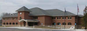
Leelanau County is a county located in the state of Michigan. Based on the 2010 census, the population was 21,708. The county seat was
until recently the unincorporated community of Leland.On August 3, 2004, county voters approved a proposal to move the county seat to Suttons
Bay Township, closer to the county's geographic center. In 2008, the county offices completed their move to a new government center built on
45 acres (180,000 m2) of county-owned land, one mile east of the unincorporated village of Lake Leelanau, where a new county law enforcement
center was completed.
Leelanau County is included in the Traverse City, MI Micropolitan Statistical Area. It is located in Northern Michigan.
Etymology - Origin of Leelanau County Name
The county's name is said to be a Native American word meaning "delight of life", but it is a neologism made up by Indian agent and ethnographer Henry Schoolcraft, who sometimes gave the name "Leelinau" to Native American women in his tales. He created many faux Indian place names in Michigan, from syllables from Ojibwe, Latin and Arabic. This source contends that the Ojibwas did not use the letter "L".
Demographics:
County QuickFacts: CensusBureau Quick Facts
Leelanau County History
A Native American word meaning "delight of life"
The county's name is said to be a Native American word meaning "delight of life" However, there is substantial authority that suggests that this is a neologism made up by Henry Schoolcraft, who sometimes gave the name "Leelinau" to some Native American women in his tales. It is noted that the Ottawas and Ojibwas did not use the letter "L".
Set Off: 1840
Organized: 1863
Geography: Land and Water
As reported by the Census Bureau, the county has a total area of 2,532 square miles (6,560 km2), of which 347 square miles (900 km2) is
land and 2,185 square miles (5,660 km2) (86%) is water. The county is coextensive with the Leelanau Peninsula.
The county has the second-highest proportion of water area of any county in the United States, behind only Keweenaw County, Michigan. Lake
Leelanau is the county's largest body of inland water, formed from the Leland River dam near Leland. Glen Lake, located within the boundaries
of Sleeping Bear Dunes National Lakeshore, is considered one of the most beautiful lakes in the world. A substantial portion
of Sleeping Bear Dunes National Lakeshore lies within the county's borders, including North Manitou and South Manitou Islands. Leelenau has
been party to substantial efforts to protect itself from growth, and to foster a nature conservancy.
Neighboring Counties
Bordering counties are as follows:
- Grand Traverse County (southeast)
- Benzie County (southwest)
Education


Click Image to Enlarge
