


Click Image to Enlarge
New York Counties
There are sixty-two counties in the State of New York. The first twelve counties in New York were created immediately after the British annexation of the Dutch colony of New Amsterdam, although two of these counties have since been abolished. The most recent county formation in New York was in 1912, when Bronx County was created from the portions of New York City that had been annexed from Westchester County.Madison County, New York
Madison County Education, Geography, and History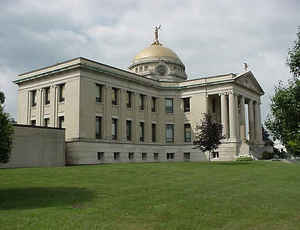
Madison County is a county located in the state of New York. Based on the 2010 census, the population was 73,442. Its county seat is
Wampsville. The county is named after James Madison, fourth President of the United States of America, and was first formed in 1806.
Madison County is part of the Syracuse, NY Metropolitan Statistical Area.
Etymology - Origin of Madison County Name
Named after James Madison, fourth President of the United States
Demographics:
County QuickFacts: CensusBureau Quick Facts
Madison County History
Madison County, was taken from Chenango county in 1806, and named after James Madison, president of the United States. Greatest length N. and 5. 33, greatest breadth E. and W. 32 miles. Centrally distant from New York 250, from Albany 108 miles. The surface of the county is much diversified. The middle and southern towns are more or less uneven and hilly; but the northern is more level. In the northern part much wheat is produced: the southern is better adapted to grass. The county is generally well watered. The route of the Chenango canal follows up the Oriskany, and crosses thence into the Chenango valley. (Historical Collections of the State of New York, Past and Present, John Barber, Clark Albien & Co., 1851)
This section was at one time the seat of the Oneida Indians, of the famed Iroquois Confederacy. The Oneida Castle site was chosen with true Indian sagacity as their village. It rested at the foot of one of the largest valleys, occupied by the Chenango River. The area in general was characterized by rolling highland, with exceptionally steep slopes, subsiding into flat, swampy land. The Oneidas thus had abundant opportunities for crude agriculture in rich soil and for unexampled fishing. The Oneidas were invaluable friends to the English and helped to check French expansion on this continent. Eventually, the Oneidas moved west. President James Madison is memorialized by the county's name.
Geography: Land and Water
As reported by the Census Bureau, the county has a total area of 662 square miles (1,713 km2), of which, 656
square miles (1,699 km2) of it is land and 6 square miles (15 km2) of it (0.86%) is water.
Madison County is located in west central New York State, east of Syracuse, north of Binghamton, and slightly north
of due west from Albany. Madison County contains the geographic center of the state at Pratts Hollow in the Town of
Eaton.
Oneida Lake and Oneida Creek define part of the northern boundary. Chittenango Creek defines part of the western
boundary.
Neighboring Counties
Bordering counties are as follows:
- Oneida County, New York - northeast
- Otsego County, New York - southeast
- Chenango County, New York - south
- Cortland County, New York - southwest
- Onondaga County, New York - west
- Oswego County, New York - northwest
Education
Colleges and universities
Cazenovia College
Colgate University
State University of New York at Morrisville


Click Image to Enlarge
