South Carolina Counties
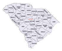
South Carolina is made up of fourty-six counties. They range in size from 392 square miles (1,016 square kilometers) in the case of Calhoun County to 1,358 square miles (3,517 square kilometers) in the case of Charleston County. The least populous county is McCormick County, with only 9,958 residents, while the most populous county is Greenville County, with a population of 395,357, despite the state's most populous city, Columbia, being located in Richland County.Berkeley County, South Carolina
Berkeley County Education, Geography, and History

Berkeley County is a county in the state of South Carolina. Based on the 2010 census, its population was 177,843. Its county seat is Moncks
Corner. After two previous incarnations of Berkeley County, the current county was created in 1882.
Berkeley County is included in the Charleston-North Charleston, SC Metropolitan Statistical Area.
Etymology - Origin of Berkeley County Name
Berkeley County was named for two of the Lords Proprietors of Carolina, Lord John Berkeley (d. 1678) and Sir William Berkeley (d. 1677).
Demographics:
County QuickFacts: CensusBureau Quick Facts
Berkeley County History
Berkeley County was named for two of the Lords Proprietors of Carolina, Lord John Berkeley (d. 1678) and Sir William Berkeley (d. 1677). The county was orginally named in 1682, and at one time it included the parishes of St. John Berkeley, St. James Goose Creek, St. James Santee, St. Stephen, andSt. Thomas and St. Denis. In 1769 this area became part of Charleston District, and it did not become a separate county again until 1882. The county seat was Mount Pleasant from 1882 until 1895, when it was moved to Moncks Corner. This area was settled in the late seventeenth century by English and French Huguenot planters and their African slaves. Many of the old rice plantations are now covered by the waters of Lake Moultrie, which was built in the 1940s as part of the Santee-Cooper hydroelectric project. Two famous Revolutionary War generals were residents of the area: William Moultrie (1730-1805) and Francis Marion (1732-1795), known as the Swamp Fox. Henry Laurens (1724-1792), president of the Continental Congress, resided at Mepkin Plantation, which many years later was purchased by publisher Henry Luce (1898-1967). Luce and his wife, writer and diplomat Clare Boothe Luce (1903-1987), are buried at Mepkin, which is now a Trappist monastery.
Geography: Land and Water
As reported by the Census Bureau, the county has a total area of 1,228 square miles (3,181 km2), of which,
1,098 square miles (2,843 km2) of it is land and 130 square miles (338 km2) of it (10.61%) is water.
Neighboring Counties
Bordering counties are as follows:
- Georgetown County, South Carolina - northeast
- Williamsburg County, South Carolina - northeast
- Charleston County, South Carolina - south
- Dorchester County, South Carolina - west
- Orangeburg County, South Carolina - northwest
- Clarendon County, South Carolina - northwest
Education


