


South Carolina Geography: The Land
Geography and Landforms of South Carolina
 Find an overview of South
Carolina geography, topography, geographic land regions, land areas, and major rivers.
Find an overview of South
Carolina geography, topography, geographic land regions, land areas, and major rivers.
Access South Carolina almanac furnishing more details on the state geography, geographical and land regions, climate and weather, elevation, land areas, bordering states, and other statistical data.
Three geographic land areas define South Carolina;
- the Atlantic Coastal Plain (comprising two thirds of the state),
- the Piedmont, and the Blue Ridge region. South Carolinians simplify this somewhat by referring to the eastern Atlantic Coastal Plain as the Low Country and
- the Piedmont and the Blue Ridge region as Up Country.
South Carolina Highest, Lowest, & Mean Elevations |
|
|---|---|
| Mean Elevation | 350 ft. |
| Highest Point | Sassafras Mountain 3,560 ft. |
| Lowest Point | Atlantic Ocean Sea level |
South Carolina Land Area (Square Miles) |
|
| Geographic Center | In Richland County, 13 mi. SE of Columbia Longitude: 80° 52.4'W Latitude: 33° 49.8'N |
| Total Area | 32,020.20 sq. mi. 40th |
| Land Area | 30,109.47 sq. mi. |
| Water Area | 1,910.73 sq. mi. 5.96% |
| Forested Land Area | 65.7% |
| Dimensions (Length - Width) |
260 miles - 200 miles |
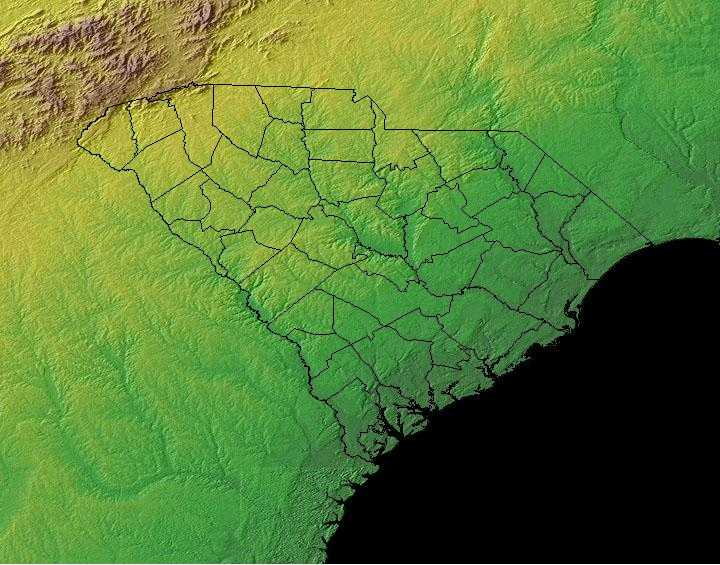
South Carolina: Physiographic Regions
Three geographic land areas define South Carolina;
- the Atlantic Coastal Plain,
- the Piedmont, and the
- Blue Ridge region.
South Carolinians simplify this somewhat by referring to the eastern Atlantic Coastal Plain as the South Carolina Low Country and the Piedmont and the Blue Ridge region as Up Country.
South Atlantic Coastal Plain
The Atlantic Coastal Plain covers two thirds of South Carolina it runs from the Atlantic Ocean extending to the west rising gradually from the southeast to the northwest.
The South Atlantic Coastal Plain covers northeastern Florida, the southern half of Georgia and the eastern halves of South Carolina and North Carolina. Its western boundary is the fall line that marks the beginning of the hilly Piedmont and its eastern boundary is the Atlantic Ocean. As part of a continuous Coastal Plain that extends from New York to Texas, it has arbitrary boundaries at the Alabama-Georgia border and at the North Carolina-Virginia border, extending into the southeast corner of Virginia only to capture the very Southeastern Great Dismal Swamp. The southeastern boundary marks a broad transitional zone into Peninsular Florida. The Atlantic coast is lined with barrier islands that support sand dune and maritime forest habitats and are backed by marshland. Estuaries are less saline marsh nearest the coast, and river valleys become increasingly wooded farther inland, supporting significant areas of bottomland hardwood forest. Pocosins and Carolina bays are non-alluvial forested wetlands unique to this physiographic area. Uplands were historically dominated by fire-maintained pine forests, with longleaf nearer the coast and on sandy soils inland and a mixture of shortleaf, loblolly, and hardwoods elsewhere.
The Outer Coastal Plain (an area in the Atlantic Coastal Plain) extends from the coast about 70 miles inland. This area is very flat. Many rivers
can be found along with swamps can be found in this area. There is another area where the most fertile soils are found this is known as the Inner Coastal
Plain and consists of rolling hills.
The Pine Barrens are located in the central Atlantic Coastal Plain. It is forested land and on the western edge of the Atlantic Coastal Plain (running
from southwest to northeast) is a line of sand hills. It is believed that the sand hills may have marked the eastern coast of the state suggesting
that the entire Atlantic Coastal Plain may have one been under water.
The Florida Uplands run about 275 miles west to east, along the northern edge of the Florida Panhandle and then extends south into the central area of the Florida peninsula. The width of the northern Florida Uplands varies from around 30 to 50 miles and is characterized by low rolling hills of red clay. Hard and softwood forests are plentiful. The section of the Florida Uplands that extends south into the peninsula, covers an area about 100 miles wide and 160 miles long. This area extends from the north, south and to the east, to separate the two sections of the East Gulf Coastal Plain and to separate the East Gulf Coastal Plain from the Atlantic Coastal Plain. The landscape in the southern Florida Uplands is characterized by low hills and many lakes. Though the Florida Uplands are only 200-300 feet above sea level, they are still higher than the regions of the Atlantic Coastal Plain and the East Gulf Coastal Plain. The highest point in Florida is found in the Florida Uplands that run along the northern edge of the panhandle. Just south of the Alabama border, west of Paxton, Britton Hill is 345 feet above sea level and is the lowest state high point in the nation.
Southern Blue Ridge
The northwestern corner of South Carolina is know as the Blue Ridge. It is part of the larger Blue Ridge that run from southern Pennsylvania south into Georgia, but the South Carolina Blue Ridge Mountains are lower and less rugged than the mountains in North Carolina. Sassafras Mountain is the highest point in South Carolina, reaching 3,554 feet above sea level.
The Southern Blue Ridge is an area of rugged mountains, long broad ridges, steep slopes, and deep ravines. It straddles the border between Tennessee and North Carolina, extending south into northeast South Carolina and northwest Georgia and north into Virginia. High Peaks spruce-fir forest grades at lower elevations into northern hardwood forest or hemlock-white pine forest on steep, north-facing slopes and Appalachian oaks on drier sites. The Appalachian oak type is the most widespread forest type in the area. Mixed mesophytic hardwood forests, also called cove forests, over on more mesic sites at low to mid-elevations. Various southern yellow pine mixes occur on dry ridges, often associated with a fire regime. There are also riparian forest types along valleys at various elevations, primarily in the lowlands. Disturbance, including fire, grazing, and storm damage, plays a major role in determining the distribution and successional status of many of these forest types.
Southern Piedmont (Southern Appalachia)
The Piedmont is located to the northwest of the Atlantic Coastal Plain. It is marked by higher elevations from 400 to 1,200 feet above sea level. It can reach as much as 1,400 feet above sea level on the western edge. The region consists of rolling hills in the east and is more hilly in the west and northwest. The Fall Line (to mark the line where the upland rivers "fall" to the lower Atlantic Coastal Plain) borders between the Piedmont region and the Atlantic Coastal Plain.
The Southern Piedmont extends through central North Carolina, South Carolina, and Georgia and into eastern Alabama. The area is characterized by irregular plains and open hills with occasional tablelands. Elevations generally range from about 30 meters to 100 meters, but rise to about 400 meters at the interface with the Southern Blue Ridge. Numerous and diverse rivers comprise a major feature of the landscape. Although the Piedmont is geologically part of Southern Appalachia, the types of vegetation that characterize the region encompass a broad transition from upland forest types to the coastal plain. By most accounts, Piedmont forests were dominated by hardwoods at the time of early European settlement, and the extent far exceeded what exists today. However, the Piedmont was by no means entirely forested prior to European settlement. Eastern grasslands and savannas were extensive and present as late as the 1700's. Because Native American settlements were apparently common in the Piedmont, agricultural fields and other larger openings were historically part of the landscape.
Potential natural forest vegetation in the Southern Piedmont is oak-hickory-pine and Southern mixed forests. Southern red, northern red, chestnut, white, post and black are the most prevalent oaks. Shagbark, pignut, and mockernut are common hickory species. Shortleaf and loblolly are dominant pine species, with scattered longleaf stands along the Fall Line with the Coastal Plain. Pines are most prevalent on disturbed sites and due to the widespread historical disturbance factor, pines have replaced oaks and hickories in many cases.

