


Click Image to Enlarge
Tennessee Counties
There are ninety-five counties in the State of Tennessee. The oldest county is Washington County, founded in 1777. The most recently formed county is Chester County (1879)Blount County, Tennessee
Blount County Education, Geography, and History
Blount County is a county located in the state of Tennessee. Based on the 2010 census, the population was 123,010. It had an estimated
population of 126,339 in 2014. The county seat is Maryville, which is also the county's largest city.
Blount County is included in the Knoxville, TN Metropolitan Statistical Area.
Etymology - Origin of Blount County Name
Named in honor of William Blount (1749-1800), member of the Continental Congress, governor of the Territory South of the River Ohio (later Tennessee), founder of Knoxville, US senator, speaker of the state senate.
Demographics:
County QuickFacts: CensusBureau Quick Facts
History of Blount County
What is today Blount County was for many thousands of years Indian territory, passed down to the Cherokee tribe that claimed the land upon
the arrival of white settlers in the late 18th century. Shortly thereafter, on July 11, 1795, Blount County became the tenth county
established in Tennessee, when the Territorial Legislature voted to split adjacent Knox and Jefferson counties. The new county was named in
honor of William Blount (1749-1800), member of the Continental Congress, governor of the Territory South of the River Ohio (later Tennessee),
founder of Knoxville, US senator, speaker of the state senate, and its county seat, Maryville, was named for his wife Mary Grainger Blount.
This establishment, however, did little to settle the differences between white immigrants and Cherokee natives, which was, for the most part,
not accomplished until an 1819 treaty.
Like many East Tennessee counties, Blount County was opposed to secession on the eve of the Civil War. In Tennessee's Ordinance of Secession
referendum on June 8, 1861, Blount Countians voted against secession by a margin of 1,766 to 414.Residents of pro-Union Cades Cove and
pro-Confederate Hazel Creek (on the other side of the mountains in North Carolina) regularly launched raids against one another during the
war.
Throughout its history the boundaries of Blount County have been altered numerous times, most notably in 1870 when a large swath of western
Blount was split into Loudon and portions of other counties. Also, the establishment of the Great Smoky Mountains National Park in 1936, while
not affecting the legal boundaries of Blount County, has significantly impacted the use of southeastern Blount County
Blount County was formed in 1795 from Knox County
(Acts of Territory South of the Ohio River 1795, Chapter 6).
There were fires at the Blount County courthouse in 1879 & 1934.
Tennessee Encyclopedia of History and Culture
Blount County is one of the oldest counties in Tennessee. Established in 1795 before statehood, it was named in
honor of Territorial Governor William Blount. Prior to white settlement the area was home to the Cherokee Indians,
who established their capital at Chota and occupied a village at Chilhowee.
White settlers arrived in the mid-1780s and established a permanent settlement at Houston's Station in 1786. The
county seat of Maryville, named after Governor Blount's wife, Mary Grainger Blount, was established and laid out in
the 1795 act creating Blount County. Throughout the nineteenth century, Maryville was a medium-sized prosperous
county seat, noted as the home of Maryville College. Originally established in 1819 as the Southern and Western
Theological Seminary, Maryville College was among the first southern schools to open its doors to Native Americans,
African Americans, and women. As industry arrived in the county at the turn of the century, Maryville boomed as a
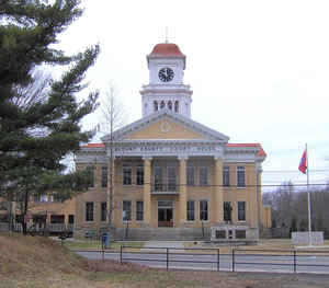
rail junction. Important properties associated with the boom include the Blount County Courthouse (1906), a
Classical Revival design by Bauman and Bauman of Knoxville; the Southern Railway freight depot; and the Indiana
Avenue historic district. Find more from the Tennessee Encyclopedia of History and Culture:
BLOUNT COUNTY
Geography: Land and Water
As reported by the Census Bureau, the county has a total area of 567 square miles (1,468 km2), of which, 559
square miles (1,447 km2) is land and 8 square miles (21 km2) (1.43%) is water.
The southern part of Blount County is part of the Great Smoky Mountains, and is protected by the Great Smoky Mountains National Park. The
crest of the range forms the county's border with Swain County, North Carolina, and includes Blount's highest point, 5,527-foot (1,685 m)
Thunderhead Mountain, and the 4,949-foot (1,508 m) Gregory Bald, a prominent grassy bald. The northern part of the county is part of the
Ridge-and-Valley Appalachians. The geologic boundary between the Blue Ridge (which includes the Smokies) and Ridge-and-Valley provinces runs
along Chilhowee Mountain, a long and narrow ridge that stretches across the central part of the county Much of Blount's topography is
characterized by elongate ridges and rolling hills— known locally as "The Foothills"— which emanate outward from the Smokies range.
The mountainous southern portion of Blount County is dotted by relatively isolated valleys known as Appalachian coves. The best known of these
valleys, Cades Cove, is one of the most visited sections of the national park, and is noted for the remnants of the Appalachian community that
occupied the cove prior to the park's formation, as well as an abundance of wildlife, especially white-tailed deer. Tuckaleechee Cove is
occupied by the city of Townsend, and Millers Cove is occupied by the community of Walland. This part of the county is also home to two large
caves: Tuckaleechee Caverns, a popular show cave, and Bull Cave, which at 924 feet (282 m) is the deepest in Tennessee.
The Tennessee River forms part of Blount's border with Knox County to the northwest. This section of the Tennessee is part of Fort Loudoun
Lake, an artificial lake created by the Tennessee Valley Authority. The Little Tennessee River, a tributary of the Tennessee, forms part of
Blount's southern border with Monroe County, and includes three artificial lakes: Tellico, Chilhowee, and Calderwood (two others, Cheoah and
Fontana, are located just upstream in North Carolina). Little River, another tributary of the Tennessee, flows northward from deep within the
Smokies and traverses the central part of the county. The river's confluence with its Middle Prong forms a popular swimming area known as the
"Townsend Wye," which is located just inside the park south of Townsend.
Neighboring Counties
Bordering counties are as follows:
- Knox County, Tennessee - north
- Sevier County, Tennessee - east
- Swain County, North Carolina - south
- Graham County, North Carolina - southwest
- Monroe County, Tennessee - southwest
- Loudon County, Tennessee - west
Education


Click Image to Enlarge
