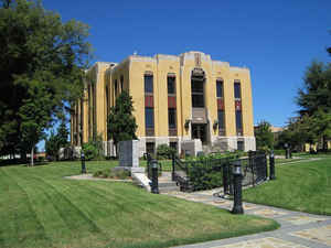
Lauderdale County, Tennessee
Lauderdale County Education, Geography, and History

Lauderdale County is a county located in the state of Tennessee. Based on the 2010 census, the population was 27,815. Its county seat is Ripley.
Etymology - Origin of Lauderdale County Name
Named in honor of James Lauderdale ( ?- 1814), Indian War and War of 1812 officer who fell leading troops against the British in 1814, a few days before the Battle of New Orleans.
Demographics:
County QuickFacts: CensusBureau Quick Facts
History of Lauderdale County
Created in 1835 from Haywood, Dyer and Tipton counties; named in honor of James Lauderdale ( ?- 1814), Indian War and War of 1812 officer who fell leading troops against the British in 1814, a few days before the Battle of New Orleans.
Lauderdale County was formed in 1835 from Dyer, Haywood and Tipton counties (Private Acts of Tennessee 1835-36, Chapter 28)
There was a fire at the Lauderdale County courthouse in 1869.
Tennessee Encyclopedia of History and Culture
In November 1835 the Tennessee General Assembly established Lauderdale County from portions of Tipton, Dyer, and
Haywood Counties. The county was named for Lieutenant Colonel James Lauderdale, who was killed in the battle of New
Orleans. The county covers 477 square miles and is bounded by the Forked Deer River, the Mississippi River (although
some areas, such as Forked Deer Island are now on the west side of the river), and the Hatchie River. The eastern
part of the county lies on the Gulf Coastal Plain while the western portion is in the Mississippi Bottom.
Native Americans used the rich resources of Lauderdale's river bottoms and hardwood forests for thousands of years
before European explorers arrived. Woodland and Mississippian Period sites, many with mounds, dot the landscape. By
the late seventeenth century the Chickasaws claimed West Tennessee. Robert Cavelier de La Salle and his party
observed their villages, and the Europeans constructed Fort Prudhomme near the mouth of the Hatchie. Despite the
Chickasaw claims, North Carolina sent Henry Rutherford to the area in 1785 to survey for land warrants. Rutherford
and his party established "Key Corner" as a landmark for marking off claims by carving his initials and a large key
into a huge sycamore on the first high ground east of the Mississippi and south of the Forked Deer. Following the
Jackson Purchase in 1818, Rutherford, his brothers, Benjamin Porter, and a man named Crenshaw settled near Key
Corner. Native Americans returned to Lauderdale County during the 1950s, when two Choctaw families migrated to the
county to work in the cotton fields. Today two Choctaw communities are in Ripley and Henning. Find more from the Tennessee Encyclopedia of History and Culture:
LAUDERDALE COUNTY
Geography: Land and Water
As reported by the Census Bureau, the county has a total area of 507 square miles (1,313 km2), of which, 470
square miles (1,218 km2) of it is land and 37 square miles (95 km2) of it (7.23%) is water.
Lauderdale County is situated on the southeastern edge of the New Madrid Seismic Zone, an area with a high
earthquake risk.
Neighboring Counties
Bordering counties are as follows:
- Dyer County (north)
- Crockett County (east)
- Haywood County (southeast)
- Tipton County (south)
- Mississippi County, Arkansas (west)
Education


