


Click Image to Enlarge
Tennessee Counties
There are ninety-five counties in the State of Tennessee. The oldest county is Washington County, founded in 1777. The most recently formed county is Chester County (1879)Macon County, Tennessee
Macon County Education, Geography, and History
Macon County is a county located in the state of Tennessee. Based on the 2010 census, the population was 22,248. Its county seat is
Lafayette.
Macon County is part of the Nashville-Davidson–Mufreesboro–Franklin, TN Metropolitan Statistical Area.
Etymology - Origin of Macon County Name
Named in honor of Nathaniel Macon (1757-1837), Revolutionary War Soldier, North Carolina legislator, congressman and senator, president of the 1835 North Carolina Constitutional Convention.
Demographics:
County QuickFacts: CensusBureau Quick Facts
History of Macon County
When the first explorers and settlers came into what is now Macon County they found the territory composed of a
wilderness inhabited by Indians and wild animals. Very little is known of the early history; however, remains of
Native American villages and burial grounds have been found. It is believed the early Indian inhabitants were from
the Chickasaw, Shawnee, Cherokee and Creek tribes.
The county was organized in accordance with the General Assembly of the state of Tennessee, 18 Jan 1842, which
provided that a new county should be established. Macon County, created from parts of Sumner and Smith counties, was
named in honor of Nathaniel Macon (1758-1837), a Revolutionary War soldier and North Carolina statesman.
The first county court met in the house of William Dunn and appointed Brittion Holland, William Dunn, Samuel
Sullivan, Eason Howell and Jefferson Short as commissioners for the purpose of selecting a suitable site for the
county seat. The place selected was on the land of John B. Johnson and was named LaFayette in honor of the legendary
French general, Marquis de LaFayette, a famous Revolutionary War figure who assisted the American colonies in
gaining their independence. The deed, dated 26 May 1842, described the property as "lying and being on the dividing
ridge between the waters of Cumberland and Big Barren River and on the waters of White Oak Creek." the land,
containing 20 acres more or less, was laid out including the public square, the streets and 75 lots. the county was
first subdivided into seven civil districts and by 1850 had increased to 12 districts.
In 1870 a portion of Macon County was cut off the southwestern corner to aid in forming Trousdale County. Macon
County is bounded north by Allen and Monroe counties, Ky; east by Clay and Jackson Counties; South by Smith and
Trousdale Counties and west by Sumner County, TN containing approximately 300 square miles. In the late 1800s, Red
Boiling Springs was widely known for the medicinal properties of the water that flowed down Salt Lick Creek. Several
hotels were built between 1890 and 1892 with numerous mineral springs and baths that made the resorts a 1920's
tourist attraction. Information from the Macon County Times in 1935 lists the following hotels in Red Boiling
Springs: Counts, Donoho, Arlington, Lincoln, Moss, Palace, Knight, Farmers, Cloyd, Jordan House, Hudson House and
Russell House. Present day Red Boiling Springs hotels now existing are the Armour, Donoho and the Thomas House.
Macon County was formed in 1824 from Smith and Sumner counties
(Private Acts of Tennessee 1841-42, Chapter 45).
Tennessee Encyclopedia of History and Culture
Located on the Eastern Highland Rim of the Upper Cumberland and bordering Kentucky is Macon County, formed by the
Tennessee General Assembly in 1842 from parts of Smith and Sumner Counties. It was named in honor of Nathaniel
Macon, a North Carolina Revolutionary War soldier, US senator, and Speaker of the House of Representatives.
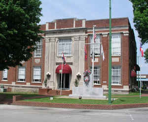
Lafayette, the largest community in the county and the county seat, was named for the French general and hero of the
American Revolution, Marie Joseph Gilbert de Motier, Marquis de Lafayette. Lafayette has had four courthouses: an
1844 two-story brick courthouse that burned in 1860; a two-story brick courthouse begun in 1861 and finished in 1866
that burned in 1901; a 1901 two-story brick and stone structure with a domed clock tower that burned in 1932; and
the present two-story brick courthouse, completed in 1933 and renovated in 1972.
Macon County encompasses 307 square miles, and the 2000 federal census reported a population of 20,386. It is one of
the few Tennessee counties that has never contained a rail line. A municipal airport is located west of Lafayette. Find more from the Tennessee Encyclopedia of History and Culture:
MACON COUNTY
Geography: Land and Water
As reported by the Census Bureau, the county has a total area of 307 square miles (796 km2), of which, 307
square miles (795 km2) of it is land and 0 square miles (0 km2) of it (0.02%) is water.
Neighboring Counties
Bordering counties are as follows:
- Monroe County, Kentucky (northeast)
- Clay County (east)
- Jackson County (southeast)
- Smith County (south)
- Trousdale County (southwest)
- Sumner County (west)
- Allen County, Kentucky (northwest)
Education


Click Image to Enlarge
