


Click Image to Enlarge
Tennessee Counties
There are ninety-five counties in the State of Tennessee. The oldest county is Washington County, founded in 1777. The most recently formed county is Chester County (1879)Pickett County, Tennessee
Pickett County Education, Geography, and History
Pickett County is a county located in the state of Tennessee. Based on the 2010 census, the population was 5,077, making it the least populous county in Tennessee. Its county seat is Byrdstown.
Etymology - Origin of Pickett County Name
Named in honor of Howell L. Pickett (1847-after 1909), attorney and member of Tennessee state house from Wilson County who moved to Arizona and continued his career in law and politics.
Demographics:
County QuickFacts: CensusBureau Quick Facts
History of Pickett County
Created 1879 from Fentress and Overton counties; named in honor of Howell L. Pickett (1847-after 1909), attorney and member of Tennessee state house from Wilson County who moved to Arizona and continued his career in law and politics.
Pickett County was formed in 1879 from Fentress and Overton counties (Acts of Tennessee 1879, Chapter 34).
There was a fire at the Pickett County courthouse in 1934.
Tennessee Encyclopedia of History and Culture
Located along Tennessee's northern border with Kentucky, Pickett County lies in the picturesque Cumberland
Plateau region of upper Middle Tennessee. In 1878 Lem Wright and Howell L. Pickett, legislators from Wilson County,
led the move to organize Pickett County. The county was established in 1879 from sections of Overton and Fentress
Counties.
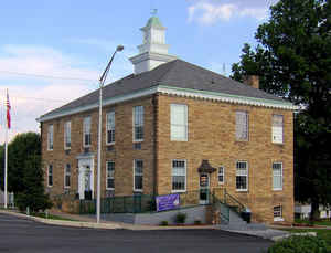
The county seat is Byrdstown, where the Pickett County Courthouse, designed in Crab Orchard stone by the Nashville
firm of Marr and Holman, is listed in the National Register of Historic Places. Originally the county seat was to be
named Wrightsville after Lem Wright, but at the last minute support went to Colonel Richard Byrd of Kingston, and
the county seat was named Byrdstown. During the Civil War, Byrd had struggled to keep Tennessee in the Union and
when Tennessee seceded, he joined the Union army. Byrdstown was incorporated in 1917.
The county encompasses 240 square miles with the Obey and Wolf Rivers flowing through the western half of the
county. Though hilly, the landscape has supported farming with corn, wheat, oats, grass, and livestock as the
primary products. In 1943 Pickett County lost most of its best farmland, as well as a fourth of its population, when
the US Army Corps of Engineers dammed the Obey River, creating the Dale Hollow Reservoir. The county continues to
be rather sparsely populated, its 2000 population numbering 4,945 residents. Find more from the Tennessee Encyclopedia of History and Culture:
PICKETT COUNTY
Geography: Land and Water
As reported by the Census Bureau, the county has a total area of 175 square miles (452 km2), of which, 163
square miles (422 km2) of it is land and 12 square miles (30 km2) of it (6.68%) is water.
Neighboring Counties
Bordering counties are as follows:
- Wayne County, Kentucky (northeast)
- Scott County (east)
- Fentress County (southeast)
- Overton County (southwest)
- Clay County (west)
- Clinton County, Kentucky (northeast)
Education
Pickett County High School - High school
Pickett County K-8 - Elementary school/Junior high school


Click Image to Enlarge
