


Click Image to Enlarge
Tennessee Counties
There are ninety-five counties in the State of Tennessee. The oldest county is Washington County, founded in 1777. The most recently formed county is Chester County (1879)Polk County, Tennessee
Polk County Education, Geography, and History
Polk County is a county located in the southeastern corner of the state of Tennessee. Based on the 2010 census, the population was 16,825.
Its county seat is Benton. The county was created November 28, 1839 from parts of Bradley and McMinn counties. The county was named after
then-governor (and future president) James K. Polk.
Polk County is included in the Cleveland, TN Metropolitan Statistical Area, which is also included in the Chattanooga-Cleveland-Dalton,
TN-GA-AL Combined Statistical Area.
Etymology - Origin of Polk County Name
Named in honor of James Knox Polk (1795-1849), clerk of the state senate, member of the state house, member and speaker of the US House, governor of Tennessee, eleventh US President.
Demographics:
County QuickFacts: CensusBureau Quick Facts
History of Polk County
Created 1839 from McMinn and Bradley counties; named in honor of James Knox Polk (1795-1849), clerk of the state senate, member of the state house, member and speaker of the US House, governor of Tennessee, eleventh US President.
Polk County was formed in 1839 from Bradley and McMinn counties
(Acts of Tennessee 1839-40, Chapter 10).
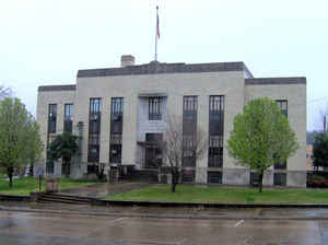
There were fires at the Polk County courthouse in 1895 and 1935.
Tennessee Encyclopedia of History and Culture
Established by the Tennessee General Assembly in 1839, Polk County was named to honor newly elected Governor
James K. Polk. It is located in the extreme southeastern corner of the state, bounded by North Carolina and Georgia.
Most of the county's 436 square miles lie within the Chilhowee and Unaka mountain ranges and contain some of the
most scenic beauty in the country, including Parksville, the Ocoee, Conasauga, and Hiwassee Rivers and 150,865 acres
of Cherokee National Forest. The rapids of the Ocoee River are internationally known to white-water enthusiasts as
the scene of the Twenty-fifth Olympic kayaking events.
Polk County's known Indian heritage extends back at least two thousand years to the early Woodland Indians. In 1540
the Spanish explorer Hernando de Soto camped near Columbus, a thriving trading post on the banks of the Hiwassee
River. The Treaty of 1819 opened the territory north of the Hiwassee to white settlement, and the 1835 Treaty of
Removal forced the Cherokees to give up their final land claims in Tennessee.
Acting on the petition of some 100 citizens, the Tennessee State Legislature created Polk County from parts of
Bradley and McMinn counties on November 28, 1839. David Ragen, as acting sheriff, was authorized to hold the first
election after the commissioners divided the county into seven civil districts. In the February 4, 1840, election,
McKamy's stock stand, located on the Old Federal Road, was chosen for the permanent county seat and named Benton in
honor of Thomas Hart Benton, US senator from Missouri. The new town was surveyed and laid out by James McKamy and
John F. Hannah into 223 lots, which were sold at auction for a total of $11,386, much of which was never collected. Find more from the Tennessee Encyclopedia of History and Culture:
POLK COUNTY
Geography: Land and Water
As reported by the Census Bureau, the county has a total area of 442 square miles (1,146 km2), of which, 435
square miles (1,127 km2) of it is land and 7 square miles (19 km2) of it is water. The total area is 1.65% water.
Much of the terrain of eastern Polk County is mountainous, including Big Frog Mountain, constituting part of the
southern Appalachian Mountains. Large tracts of Polk County are part of the Cherokee National Forest. The Ocoee
River, site of whitewater slalom events in the Atlanta 1996 Summer Olympic Games, runs through Polk County and is
vital to one of the county's major industries, whitewater rafting. The calmer Hiwassee River, a tributary of the
Tennessee River which flows through northern Polk County, is also used for rafting and tubing.
Neighboring Counties
Bordering counties are as follows:
- Monroe County (northeast)
- Cherokee County, North Carolina (east)
- Fannin County, Georgia (southeast)
- Murray County, Georgia (southwest)
- Bradley County (west)
- McMinn County (northwest)
Education
Polk County is home to two high schools, Copper Basin and Polk County. Polk County High School holds one of the most active FFA Chapters in
the State. Additionally, the school has won multiple national titles, such as the Future Business Leaders of America Web Development
championship.
Polk County's other schools are Benton Elementary, Copper Basin Elementary, and South Polk Elementary, Coalhill Elementary School.


Click Image to Enlarge
