


Click Image to Enlarge
Tennessee Counties
There are ninety-five counties in the State of Tennessee. The oldest county is Washington County, founded in 1777. The most recently formed county is Chester County (1879)Smith County, Tennessee
Smith County Education, Geography, and History
Smith County is a county located in the state of Tennessee. Based on the 2010 census, the population was 19,166. Its county seat is
Carthage. The county was created in 1799 and is named for Daniel Smith, a Revolutionary War veteran who made the first map of Tennessee and
served as a United States senator.
Smith County is part of the Nashville-Davidson–Murfreesboro–Franklin, TN Metropolitan Statistical Area
Etymology - Origin of Smith County Name
Named in honor of Daniel Smith (1748-1818), surveyor, Revolutionary War officer, secretary of the Territory South of the River Ohio (later Tennessee), maker of the first map of the state, US senator.
Demographics:
County QuickFacts: CensusBureau Quick Facts
History of Smith County
Created 1799 from Sumner County and Indian lands; named in honor of Daniel Smith (1748-1818), surveyor, Revolutionary War officer, secretary of the Territory South of the River Ohio (later Tennessee), maker of the first map of the state, US senator.
Smith County was formed in 1799 from Sumner County and Indian lands. (Acts of Tennessee 1799, Chapter 2).
Tennessee Encyclopedia of History and Culture
Created by the Tennessee General Assembly on October 26, 1799, Smith County was named in honor of General Daniel
Smith. Carved out of Sumner County, the new county covered a large territory of 314 square miles. Immigrants of
Scots-Irish, English, and German descent established thriving towns and productive farms along the courses of the
two rivers and abundant streams that flow through the fertile bottom lands. The majority of the settlers, many of
whom held land warrants for Revolutionary War service, came from North Carolina. Once the pioneers cleared land,
planted a crop, and built a shelter, churches and schools soon followed. The Presbyterians, Methodists, and Baptists
all had active congregations. Clinton College at New Middleton, Geneva Academy at Carthage, Shady Grove Academy at
Gordonsville were among the early schools.
In 1804 a heated election was held for selection of a permanent county seat. The contest raged between proponents
(the polecats) of Bledsoesborough, a site on the Cumberland near Dixon Springs, and supporters (the moccasin gang)
of William Walton, whose land grant was situated at the confluence of the Cumberland and Caney Fork Rivers. Walton,
a Revolutionary veteran, operated a ferry and tavern at the site. An abundance of refreshments, including a full
supply of whiskey furnished by Colonel Walton, may have influenced the victory claimed by the moccasins, who
determined Carthage, destined to become one of the most important towns in Middle Tennessee during the steamboat
era, as the county seat. Throughout the winter of 1805 the town was laid out and public buildings were constructed.
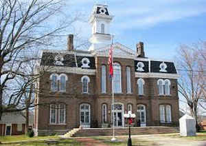
By 1879 a new courthouse building, "the handsomest in the State," was erected and continues to grace the town
square. It was placed on the National Register of Historic Places in 1979. Find more from the Tennessee Encyclopedia of History and Culture:
SMITH COUNTY
Geography: Land and Water
As reported by the Census Bureau, the county has a total area of 325 square miles (843 km2), of which, 314
square miles (814 km2) of it is land and 11 square miles (28 km2) of it (3.36%) is water.
Neighboring Counties
Bordering counties are as follows:
- Macon County (north)
- Jackson County (northeast)
- Putnam County (east)
- DeKalb County (southeast)
- Wilson County (west)
- Trousdale County (northwest)
Education


Click Image to Enlarge
