


Click Image to Enlarge
Tennessee Counties
There are ninety-five counties in the State of Tennessee. The oldest county is Washington County, founded in 1777. The most recently formed county is Chester County (1879)Tipton County, Tennessee
Tipton County Education, Geography, and History
Tipton County is a county located on the western end of the state of Tennessee. Based on the 2010 census, the population was 61,081. Its
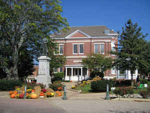
county seat is Covington.
Tipton County is part of the Memphis, TN–MS–AR Metropolitan Statistical Area.
Etymology - Origin of Tipton County Name
Named in honor of Jacob Tipton (?-1791), organizer for the defense of the Northwest Territory against hostile Indians who was killed leading an attack in 1791.
Demographics:
County QuickFacts: CensusBureau Quick Facts
History of Tipton County
Created 1823 from Indian lands; named in honor of Jacob Tipton (?-1791), organizer for the defense of the Northwest Territory against hostile Indians who was killed leading an attack in 1791.
Tipton County was formed in 1823 from Indian lands (Acts of Tennessee 1823, Chapter 126).
Tennessee Encyclopedia of History and Culture
The area forming West Tennessee was part of the Chickasaw Nation until 1818, when the territory was opened for
settlement under the terms of the Jackson Purchase. An 1819 act by the general assembly divided the new territory
into five districts. The first county in the Western District was Shelby, which was organized at the village of
Chickasaw Bluff in 1819. Tipton County was formed from Shelby County in 1823 and named for Captain Jacob Tipton who
was killed leading his men in a battle near Fort Wayne in 1791. Tipton's son, Armistead Blevins, who supervised the
organization of Shelby County, was present when Tipton County was formed. Covington, situated near the center of the
county, was established as the county seat in 1826. Its name honored Leonard Wales Covington, a Maryland native who
was killed in the battle of Chrysler's Field in 1813.
In 1833 the Tennessee Gazetteer described Covington as a post town and seat of justice thirty-eight miles from
Memphis. Covington was originally divided into 106 lots on seven streets. Most construction was of frame and log,
with the exception of a brick jail. In addition to the courthouse and jail, Covington had seven stores, two taverns,
a surveyor's office, three or four physicians' offices, a similar number of lawyers' offices, and thirty or forty
houses. Located on a tributary of the Hatchie River, Covington remained isolated from the steamboat trade of the
nineteenth century and did not achieve commercial significance until the arrival of the Newport News and Mississippi
Valley Railroad in 1873. Between 1873 and 1880, over 6,000 new residents arrived in Covington to take advantage of
the commercial and industrial opportunities created by the arrival of the railroad. Economic expansion rose even
faster after the takeover of the railroad by the Illinois Central in the 1890s. The town received its first
telephone service and electric street lights in 1894. By 1920 Covington had a population of over 3,400 and boasted a
weekly newspaper; three banks; an electric light plant; a water works; and a cotton mill, a cottonseed oil mill, and
other manufacturing enterprises. Today, the downtown historic district contains an array of architecturally
significant commercial and residential buildings. Find more from the Tennessee Encyclopedia of History and Culture:
TIPTON COUNTY
Geography: Land and Water
The major north-south route, US Highway 51, bisects Tipton County into a western half and eastern half, and
passes through Covington. The western boundary of Tipton County is the Mississippi River, where Tennessee meets
Arkansas.
As reported by the Census Bureau, the county has a total area of 475 square miles (1,230 km2), of which, 459
square miles (1,190 km2) of it is land and 15 square miles (40 km2) of it (3.23%) is water.
Tipton County is situated on the southeastern edge of the New Madrid Seismic Zone, an area with a high earthquake
risk.
Neighboring Counties
Bordering counties are as follows:
- Lauderdale County (north)
- Haywood County (east)
- Fayette County (southeast)
- Shelby County (south)
- Crittenden County, Arkansas (southwest)
- Mississippi County, Arkansas (northwest)
Education


Click Image to Enlarge
