


Click Image to Enlarge
Washington Counties
There are thity-nine counties in the state of Washington. Washington was carved out of the western part of Washington Territory and admitted to the Union as the 42nd state in 1889. The first counties were created from unorganized territory in 1845.Adams County, Washington
Adams County Education, Geography, and History
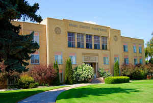
Adams County is a county located in the state of Washington. Based on the 2010 census, the population was 18,728. The county seat is at
Ritzville, and its largest city is Othello. The county was formed out of Whitman County on November 28, 1883 and is named for the second
President of the United States, John Adams.
Adams County comprises the Othello, WA Micropolitan Statistical Area, which is also included in the Moses Lake-Othello, WA Combined
Statistical Area.
Etymology - Origin of Adams County Name
John Adams, the second president of the United States.
Demographics:
County QuickFacts: CensusBureau Quick Facts
Adams County History
Adams County was organized March 1, 1836. A large tract of land lying between Allen and Randolph counties had been previously called Adams County, however, no organization had been effected.
The current county was formed out of Whitman County on November 28, 1883 and is named for the second President of the United States, John Adams.
Adams County is a predominantly rural county located in southeastern Washington, with Ritzville serving as county seat.
Economic
Adams County is an agricultural and livestock economic based region interspersed with pre-historic ice age flood channels, lakes and streams in a semi-arid upland steppe environment that offers a wide range of recreational activity.
Agricultural pursuits include dry-land wheat farming, irrigated apple orchards, and field crops (primarily potatoes). The vegetable- and fruit-processing industry, especially potato processing and French fry manufacturing, provides most of the county's industrial employment. As of 2006, Adams County's population was 52 percent Hispanic, with most Hispanic residents being of Mexican heritage.
Industrial activity is related primarily to the vegetable and fruit processing industry with various support
industries.
Geography: Land and Water
As reported by the Census Bureau, the county has a total area of 1,930 square miles (4,998 km2), of which, 1,925 square miles (4,986 km2) of it is land and 5 square miles (12 km2) of it (0.25%) is water.
Neighboring Counties
Bordering counties are as follows:
- Lincoln County, Washington north
- Whitman County, Washington east
- Franklin County, Washington south
- Grant County, Washington west
Education


Click Image to Enlarge
