


Click Image to Enlarge
Washington Counties
There are thity-nine counties in the state of Washington. Washington was carved out of the western part of Washington Territory and admitted to the Union as the 42nd state in 1889. The first counties were created from unorganized territory in 1845.Walla Walla County, Washington
Walla Walla County Education, Geography, and History
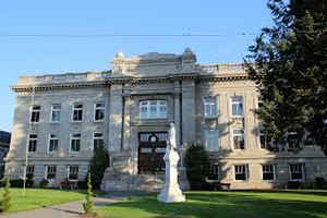
Walla Walla County is a county located in the state of Washington. Based on the 2010 census, its population was 58,781. The county seat and
largest city is Walla Walla. The county was formed on April 25, 1854 and is named after the Walla Walla tribe of Native Americans.
Walla Walla County is included in the Walla Walla, WA Metropolitan Statistical Area.
Etymology - Origin of Walla Walla County Name
The Walla Walla Native American tribe.
Demographics:
County QuickFacts: CensusBureau Quick Facts
Walla Walla County History
Walla Walla County was created 25 April 1854 from Clark County. Walla Walla County covers 1,271 square miles in south central Washington, ranking 26th in size among Washington's 39 counties. It is bounded to the east by Columbia County, to the north by the Snake River and Franklin County, to the west by Benton and Franklin counties and the Columbia River, and to the south by the state of Oregon. The city of Walla Walla is the County Seat. The land that would become Walla Walla County was one of the earliest areas between the Rocky Mountains and the Cascade Mountains to be permanently settled by non-Indians, and for that reason it is sometimes referred to as the cradle of Pacific Northwest history. The 1847 Whitman Massacre and the 1855 Treaty Council in Walla Walla are among the most significant events to have occurred within what is now Walla Walla County. Agriculture is the most significant industry in the county, especially the cultivation of wheat, onions, and wine grapes. Walla Walla County has a population of 54,200 as reported in the 2000 Census.
Geography: Land and Water
As reported by the Census Bureau, the county has a total area of 1,299 square miles (3,365 km2), of which,
1,271 square miles (3,291 km2) of it is land and 29 square miles (74 km2) of it (2.21%) is water.
Neighboring Counties
Bordering counties are as follows:
- Columbia County, Washington - east
- Umatilla County, Oregon - south
- Benton County, Washington - west
- Franklin County, Washington - northwest
Education


Click Image to Enlarge
