


Georgia Geography: The Land
Geography and Landforms of Georgia
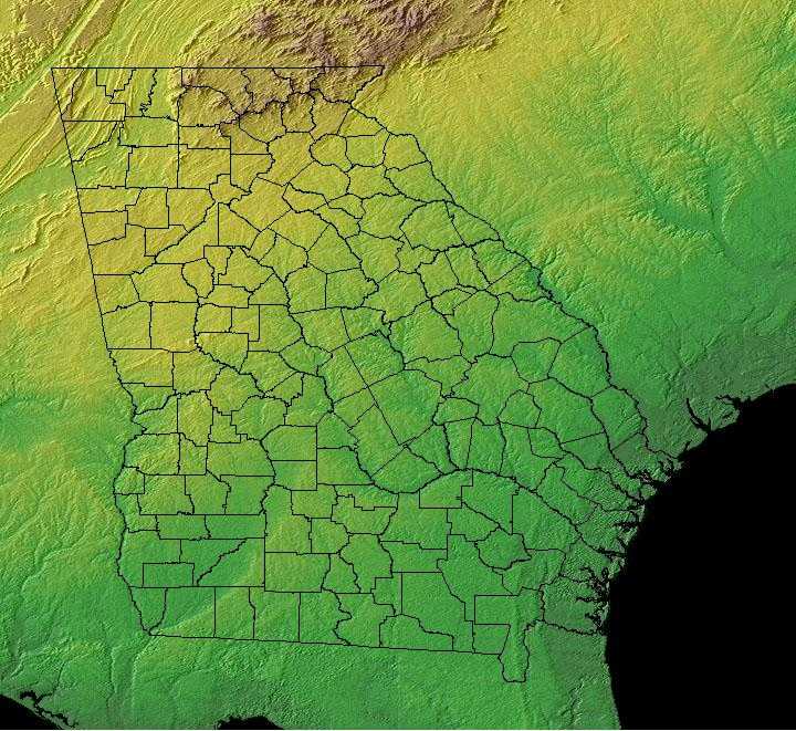
Find an overview of Georgia geography, topography, geographic land regions, land areas, and major rivers.
Access Georgia almanac, furnishing more details on the state geography, geographical and land regions, climate and weather, elevation, land areas, bordering states, and other statistical data.
Georgia falls within five major physiographic regions: the Blue Ridge Mountains in the northeast, the Ridge and Valley Providence and the Cumberland Plateau in the northwest, the Piedmont across Georgia's center, the South Atlantic Coastal Plain in the south and East Gulf Coastal Plain.
Elevations range from sea level to 4,784 feet at Brasstown Bald in the Blue Ridge Mountains. The Blue Ridge mountain area features the southern terminus of the Appalachian Trail, a 2,100 mile hiking trail ending in Maine. The mountain range's peaks were once higher than the Rockies, but some 100 million years of erosion has worn them down to about a quarter of their original height. Nonetheless, the mountains attract millions of visitors each year, particularly in the summer and fall.
Georgia is the largest state east of the Mississippi River and is 21st in size among the other states.
All of Georgia's rivers are formed either within the state or along its boundaries; no river flows into Georgia from another state. The Altamaha, Savannah, and Chattahoochee have the highest average flow rates. Among other major rivers are the Flint, Oconee, Ocmulgee, Coosa, Ogeechee, and Satilla. Recently, there has been a growing concern regarding Georgia's water resources due to drought conditions and population growth.
Georgia Highest, Lowest, & Mean Elevations |
|
|---|---|
| Mean Elevation | 600 ft. |
| Highest Point | Brasstown Bald 4,784 ft. |
| Lowest Point | Atlantic Ocean Sea level |
Georgia Land Area (Square Miles) |
|
| The mountains of the north, part of the Appalachian Mountains system, give way to the transitional Piedmont Plateau and its fertile, gently rolling hills. The southern half of the state is covered by the low-lying coastal plain; just offshore are the popular resorts of the Georgia Sea Islands. Along the border with Florida is the Okefenokee Swamp, a huge wilderness area with unique flora and fauna. The climate is temperate but variable throughout the state. About 63% of the population lives in urban areas. | |
| Geographic Center | In Twiggs County, 18 mi. SE of Macon Longitude: 83° 29.7'W Latitude: 32° 42.8'N |
| Total Area | 59,424.77 sq. mi. 24th |
| Land Area | 57,906.14 sq. mi. 97.45% |
| Water Area | 1,518.63 sq. mi. 2.55% |
| Forested Land Area | 65.9% |
| Dimensions (Length - Width) |
300 miles - 230 miles |
Georgia: Physiographic Regions
The territory of Georgia can be divided into six main land regions: the Appalachian Plateau, the Appalachian Ridge and Valley Region, the Blue Ridge, the Piedmont, the Atlantic Coastal Plain, and the East Gulf Coastal Plain.
South Atlantic Coastal Plain
The Atlantic Coastal Plain is part of the Atlantic Plain that stretches from Massachusetts to the Florida peninsula and around the Gulf of Mexico. The Atlantic Coastal Plain lies in southeast Georgia along the state's Atlantic Ocean shoreline. Occupying about 1/4 of Georgia, the Atlantic Coastal Plain is characterized by a flat landscape. The Okefenokee Swamp lies in the southern part of the Atlantic Plain and in part of the East Gulf Coastal Plain. The rivers in the Atlantic Coastal Plain drain into the Atlantic Ocean.
The South Atlantic Coastal Plain covers northeastern Florida, the southern half of Georgia and the eastern halves of South Carolina and North Carolina.
Its western boundary is the fall line that marks the beginning of the hilly Piedmont and its eastern boundary is the Atlantic Ocean. As part of a continuous
Coastal Plain that extends from New York to Texas, it has arbitrary boundaries at the Alabama-Georgia border and at the North Carolina-Virginia border,
extending into the southeast corner of Virginia only to capture the very Southeastern Great Dismal Swamp. The southeastern boundary marks a broad transitional
zone into Peninsular Florida. The Atlantic coast is lined with barrier islands that support sand dune and maritime forest habitats and are backed by
marshland. Estuaries are less saline marsh nearest the coast, and river valleys become increasingly wooded farther inland, supporting significant areas
of bottomland hardwood forest. Pocosins and Carolina bays are non-alluvial forested wetlands unique to this physiographic area. Uplands were historically
dominated by fire-maintained pine forests, with longleaf nearer the coast and on sandy soils inland and a mixture of shortleaf, loblolly, and hardwoods
elsewhere.
The Florida Uplands run about 275 miles west to east, along the northern edge of the Florida Panhandle and then extends south into the central area of the Florida peninsula. The width of the northern Florida Uplands varies from around 30 to 50 miles and is characterized by low rolling hills of red clay. Hard and softwood forests are plentiful. The section of the Florida Uplands that extends south into the peninsula, covers an area about 100 miles wide and 160 miles long. This area extends from the north, south and to the east, to separate the two sections of the East Gulf Coastal Plain and to separate the East Gulf Coastal Plain from the Atlantic Coastal Plain. The landscape in the southern Florida Uplands is characterized by low hills and many lakes. Though the Florida Uplands are only 200-300 feet above sea level, they are still higher than the regions of the Atlantic Coastal Plain and the East Gulf Coastal Plain. The highest point in Florida is found in the Florida Uplands that run along the northern edge of the panhandle. Just south of the Alabama border, west of Paxton, Britton Hill is 345 feet above sea level and is the lowest state high point in the nation.
Southern Blue Ridge Mountains
A small section of the Blue Ridge is found in northeastern Georgia north of the Piedmont. The mountain peaks in the Blue Ridge area rise 2,000 to almost 5,000 feet above sea level; more than 20 above 4,000 feet. These mountains are forested with hardwoods and pine softwoods. The rushing rivers in the Blue Ridge provide hydro-electric power to Georgia. Georgia's highest mountains are found in the Blue Ridge area, including Brasstown Bald, or Mount Etonah, which rises 4,784 feet above sea level.
The Southern Blue Ridge is an area of rugged mountains, long broad ridges, steep slopes, and deep ravines. It straddles the border between Tennessee and North Carolina, extending south into northeast South Carolina and northwest Georgia and north into Virginia. High Peaks spruce-fir forest grades at lower elevations into northern hardwood forest or hemlock-white pine forest on steep, north-facing slopes and Appalachian oaks on drier sites. The Appalachian oak type is the most widespread forest type in the area. Mixed mesophytic hardwood forests, also called cove forests, over on more mesic sites at low to mid-elevations. Various southern yellow pine mixes occur on dry ridges, often associated with a fire regime. There are also riparian forest types along valleys at various elevations, primarily in the lowlands. Disturbance, including fire, grazing, and storm damage, plays a major role in determining the distribution and successional status of many of these forest types.
Southern Piedmont (Southern Appalachia)
Northwest of the Atlantic Coastal Plain and the East Gulf Coastal Plain, the Georgia Piedmont cuts across the state. The Southern Piedmont extends through central North Carolina, South Carolina, and Georgia and into eastern Alabama. The Piedmont is marked by a hilly landscape in the north where it abuts the Appalachian regions at around 1,500 feet above sea level. The land loses elevation to the southeast, where the hills become more gently rolling and the land is only about 400 feet above sea level. The area is characterized by irregular plains and open hills with occasional tablelands. Elevations generally range from about 30 meters to 100 meters, but rise to about 400 meters at the interface with the Southern Blue Ridge.The clear difference in landscape where the southeastern edge of the Piedmont meets the Atlantic Coastal Plain and the Gulf Coastal Plain is called the Fall Line. It is along this line that the rivers flowing from the higher elevations of the Piedmont fall to the lower Coastal Plains forming waterfalls and rapids.
Numerous and diverse rivers comprise a major feature of the landscape. Although the Piedmont is geologically part of Southern Appalachia, the types of vegetation that characterize the region encompass a broad transition from upland forest types to the coastal plain. By most accounts, Piedmont forests were dominated by hardwoods at the time of early European settlement, and the extent far exceeded what exists today. However, the Piedmont was by no means entirely forested prior to European settlement. Eastern grasslands and savannas were extensive and present as late as the 1700's. Because Native American settlements were apparently common in the Piedmont, agricultural fields and other larger openings were historically part of the landscape.
Potential natural forest vegetation in the Southern Piedmont is oak-hickory-pine and Southern mixed forests. Southern red, northern red, chestnut,
white, post and black are the most prevalent oaks. Shagbark, pignut, and mockernut are common hickory species. Shortleaf and loblolly are dominant
pine species, with scattered longleaf stands along the Fall Line with the Coastal Plain. Pines are most prevalent on disturbed sites and due to the
widespread historical disturbance factor, pines have replaced oaks and hickories in many cases.
Southern Ridge and Valley
This physiographic area consists of both the Southern end of the Ridge and Valley system as well as the tablelands of the Southern Cumberland Plateau. This is a fertile valley in northwestern Georgia that is separated by parallel ridges of sandstone. It descends to the Coastal Plain to the south and rises to the Blue Ridge to the east. It is located in eastern Tennessee, northwest Georgia, and northeast Alabama, and is arbitrarily separated from the Mid-Atlantic Ridge and Valley at the Tennessee-Virginia border. Upland deciduous forest, the most common naturally-occurring cover type, is predominantly mixed mesophytic, oak-hickory, or oak-pine forest. There is also a considerable area dominated by pine, either shortleaf or loblolly.
The Cumberland Plateau
The Cumberland Plateau begins near Birmingham, Alabama, and crosses the extreme northwest corner of Georgia before entering Tennessee just to the west of Chattanooga. Northwest of Knoxville, the plateau becomes highly dissected due to erosion, and the region- although geologically still a plateau- is called the Cumberland Mountains.
The two principal features of the Cumberland Plateau in Georgia are Sand Mountain and Lookout Mountain, which are separated by 2-mile-wide Lookout Valley, in which the towns of Trenton and Rising Fawn are located.
From a physiographic standpoint, the flat-topped mountains of the Cumberland Plateau are quite different from the narrow Armuchee Ridges beyond the Chickamauga Valley to the east. Geologically, the Cumberland Plateau is transitional between the flat-lying sedimentary beds of central Tennessee and the ridges and valleys to the east in Georgia, which show more intensive folding and faulting.
The flat top of the Cumberland Plateau is sandstone which, while harder than limestone or shale, has nevertheless been carved and sculpted for millions of years by wind and water. Because of a tendency to fracture into squarish blocks, the sandstone has weathered into fantastic boulder formations in places like Rocktown and the Zahnd Tract, commercially called "rock cities." In addition, thick layers of soft, water-soluble limestone undergird the Cumberland Plateau. Because the top is actually slightly concave, surface water accumulates and seeps downward through cracks and crevices, where it dissolves the limestone and creates miles of underground passages or caves, issuing forth at numerous springs around the base of the mountain.
The great gulfs, or canyons, eroded in the sides of the Cumberland Plateau are spectacular in a geologic, biotic, and scenic sense. Two on Lookout Mountain are notable- a wide canyon known as Johnson's Crook, and a narrow one called Sitton's Gulch and renamed Cloudland Canyon.
Pigeon Mountain, a thumblike protrusion from Lookout Mountain, deserves special mention. It is a geological, botanical, and zoological treasure house. Happily, most of it was purchased by Heritage Trust funds under the farsighted Carter administration.
East Gulf Coastal Plain
The East Gulf Coastal Plain covers almost 1/4 of Georgia in the southwest. Similar to the flat landscape of the Atlantic Coastal Plain, the flat East Gulf Coastal Plain's soil is less sandy. Part of the Okefenokee Swamp lies in the East Gulf Coastal Plain. The great Suwannee River, like all rivers in this land region, flows south into the Gulf of Mexico.

