


Pennsylvania Geography: The Land
Geography and Landforms of Pennsylvania
 Find an overview of Pennsylvania
geography, topography, geographic land regions, land areas, and major rivers.
Find an overview of Pennsylvania
geography, topography, geographic land regions, land areas, and major rivers.
Access Pennsylvania almanac, furnishing more details on the state geography, geographical and land regions, climate and weather, elevation, land areas, bordering states, and other statistical data.
Pennsylvania is one of the Mid-Atlantic states. It is known as the Keystone State because it is geographically in the center of the "arch" formed by the original 13 states. Six are located to the north and six to the south. Pennsylvania's width is 312 miles. The distance between its northern and southern boundaries is 158 miles. It is America's 33rd largest state.
The landforms of Pennsylvania had their origin about 500 million years ago, when a vast interior sea, up to several hundred miles wide, occupied the area from New England to Alabama. For about 250 million years, the rivers originating from an extensive mountain chain on the east poured sediments into the great Appalachian downwarp basin. Great swamps prevailed in southwestern Pennsylvania for millions of years and provided the vegetation that ultimately became the coal beds of the area.
Pennsylvania Highest, Lowest, & Mean Elevations |
|
|---|---|
| Mean Elevation | 1,100 ft. |
| Highest Point | Mt. Davis 3,213 ft. |
| Lowest Point | Delaware River Sea level |
Pennsylvania Land Area (Square Miles) |
|
| Geographic Center | In Centre County, 21/2 mi. SW of Bellefonte Longitude: 77° 44.8'W Latitude: 40° 53.8'N |
| Total Area | 46,055.24 sq. mi. 33rd |
| Land Area | 44,816.61 sq. mi. 97.32% |
| Water Area | 1,238.63 sq. mi. 2.68% |
| Forested Land Area | 58.9% |
| Dimensions (Length - Width) |
283 miles - 160 miles |
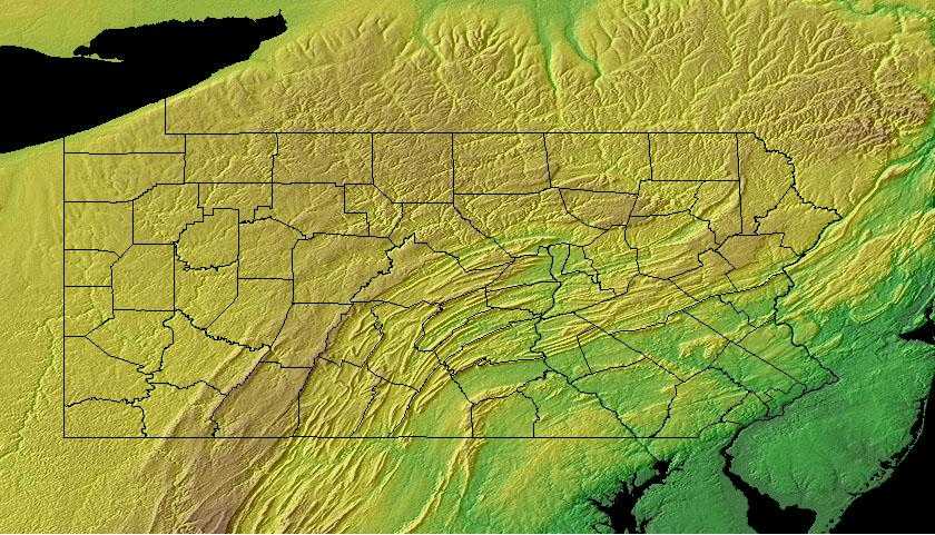
Pennsylvania: Physiographic Regions
The Allegheny Mountains run diagonally from the southwest to the northeast with piedmont and coastal plains in the southeast triangle. The Allegheny Front, as it's called, cuts a diagonal line across the state. In the northwest, the plateau falls to the Lake Erie lowlands and, finally, Lake Erie. There are six physiographic provinces in Pennsylvania:
- Atlantic Coastal Plain Province
- Lowland and Intermediate Upland Section
- Piedmont Province
- Piedmont Upland Section
- Piedmont Lowland Section
- Gettysburg-Newark Lowland Section
- Ridge and Valley Province
- South Mountain Section
- Great Valley Section
- Blue Mountain Section
- Anthracite Upland Section
- Anthracite Valley Section
- Appalachian Mountain Section
- Susquehanna Lowland Section
- New England Province
- Reading Prong Section
- Appalachian Plateaus Province
- Glaciated Pocono Plateau Section
- Glaciated Low Plateau Section
- Glaciated High Plateau Section
- Allegheny Front Section
- Allegheny Mountain Section
- Deep Valleys Section
- Pittsburgh Low Plateau Section
- Waynesburg Hills Section
- High Plateau Section
- Northwestern Glaciated Plateau Section
- Central Lowland Province
- Eastern Lake Section
Atlantic Coastal Plain Province
This region runs across the southeastern corner of the state. A flat low area that falls to sea level where it meets the Delaware River.
Piedmont Province
The eastern border of the Piedmont is the fall line, where resistant volcanic rock gives way to the sands and clays of the Coastal Plain. To the west, the Piedmont ends with the edge of the higher and more rugged Blue Ridge and Ridge and Valley regions of the Appalachian Mountains The Mid-Atlantic Piedmont is arbitrarily separated from the Southern Piedmont at the North Carolina-Virginia line, and extends north through Virginia, Maryland, and Pennsylvania before terminating in northern New Jersey. The rolling topography of the Piedmont formerly supported an extensive hardwood forest, with an oak-hickory type predominant in southern portions and Appalachian oak to the north. Large areas in the Virginia portion were dominated by Loblolly-shortleaf pine or pine-oak forests. Today, roughly 45% of the physiographic area is forested, and about an equal portion is in agricultural production. The remainder is experiencing rapid urbanization, especially in the vicinity of Washington D.C. and Philadelphia.
Ridge and Valley Province
The Northern Ridge and Valley extends from southeastern Pennsylvania, through northwestern New Jersey and southeastern New York nearly to the base of the Adirondack Mts. It includes portions of several major river valleys, including the Hudson, Delaware, and Susquehanna Rivers. Ecologically, this is a transitional area, with forested ridges grading from primarily oak-hickory forests in the south to northern hardwood forests further north. Pine-oak woodlands and barrens and hemlock ravine forests are also important along ridges, whereas bottomland and riparian forests are important in the valleys, which are now largely cleared for agricultural and urban development. Roughly 50% of the physiographic area is forested today, the vast majority occurring at higher elevations. About 40% of the area is in agricultural production, primarily a mixture of dairy pastureland and corn. Over 200,000 ha is state forest land in PA and NJ; other important public lands include High Point State Park (NJ) and Wallkill National Wildlife Refuge.
New England Province
The New England Province's Reading Prong Section consists of circular to linear, rounded low hills or ridges that project upward in significant
contrast to the surrounding lowlands. The hills and ridges are made up of granitic gneiss, granodiorite, and quartzite. These rocks are very resistant
to erosion and thus the hills and ridges stand higher than the softer sedimentary rocks that surround them. The slopes of these hills and ridges are
steep and have a very well defined change in slope where the bases of the hills and ridges meet the lower and gentler slopes of adjacent Sections.
The streams eroding into the hills and ridges are short and steep. Local relief is 300 to 600 feet and elevations range from 140 to 1,364 feet.
This Section occurs in southeastern Pennsylvania in the southern parts of Lebanon, Berks, Lehigh, and Northampton Counties. The Section is crossed
by some local roads. A good appreciation of the Section can be gained along Pennsylvania Route 73 in Berks County.
The Outstanding Scenic Geologic Features in the Section include: Cushion Peak, Devils Hump, Eagle Peak, Elephant Rock, Hexenkopf Rock, Jasper Cliffs,
Mount Penn Scenic Lookout, and Vera Cruz Jasper Pits. Also in the Section but not shown on the map are: near Jasper Cliffs - Bauer Rock; near Devils
Hump - Owl Head and Pinnacle Peak.
Appalachian Plateaus Province
The Allegheny Plateau covers much of west-central Pennsylvania, the southern tier of New York to the base of the Adirondack Mt., and a portion of northeast Ohio. This area consists primarily of extensively forested uplands, including the Catskill Mountains in NY, Pocono Mountains in PA, and Allegheny National Forest in both states. This is a transitional area dominated by oak-hickory forests towards the south and beech-maple forests towards the north. White pine and hemlocks also are an important component of the forests, more so historically. Small but important patches of spruce-fir forest occur on the Catskill High Peaks and at a few sites in northeastern PA. Several major river valleys dissect the highlands, and the Finger Lakes of central NY drain the northern portion of the physiographic area towards Lake Ontario. Roughly 70% of this area is forested today, with agriculture dominating primarily at lower elevations in western New York, the Susquehanna River valley, and in Ohio.
Central Lowland Province
The Eastern Lake Section consists of a series of northwest-sloping, lake-parallel, low-relief ridges. These ridges are made up of unconsolidated surficial materials, mainly sands and gravels, that were deposited during the most recent deglaciation of the area about 18,000 years ago. Steep-sided, narrow valleys cut through these ridges into the underlying shales and siltstones and flow into Lake Erie. Originally, the ridge bordering Lake Erie sloped gently into the lake. However, erosion of the shoreline has caused the lake-land interface to move southeastward so that today there is a steep bluff adjacent to the lake. Continued erosion of this bluff is a primary environmental problem in the area. Local relief in the Section is less than 100 feet and generally half that. Elevation is 570 feet at Lake Erie and rises southward to a high of 1,000 feet. Drainage pattern is parallel and streams are oriented normal to the Lake Erie shoreline.
The length of the Section can be seen very well along the Pennsylvania parts of US Route 20, Interstate 90 west of Erie, and Pennsylvania Route 5. Short segments of Pennsylvania Routes 215, 18, 98, 97, and 89 cross the Section normal to the Lake Erie shoreline.
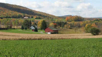
Pennsylvania Landscape and Landforms:
Ohio Hills
Landforms within the Ohio Hills consist primarily of dissected, unglaciated plateaus ranging in elevation from 150 m to 450 m, with some valleys as low as 100 m and some mountainous areas reaching 1,100 m. A majority of the planning unit was dominated historically by oak-hickory forests; today these cover roughly 4.3 million ha (10.7 million ac), or 54% of the physiographic area. Numerous patches of northern hardwood forest occur on north-facing hillsides, particularly near the edges of the Allegheny Mountains in West Virginia and Allegheny Plateau in Ohio. Historically, oak-hickory and oak-pine regeneration was dependent on fire, and recent policies of fires suppression in the southern Appalachians has had major (primarily negative) effects on native forest composition and structure. Human populations are relatively sparse through most the physiographic area and are largely confined to the larger valleys; Pittsburgh, PA and Morgantown, WV are the largest cities. Roughly 40% of the physiographic area is in agricultural production or urban development, mostly in the northern half. Timber extraction has been a major activity throughout the history of this region, and it continues to be important on both public (10% of area) and privately owned forest lands. Extraction of minerals, oil and gas, and coal are also important land uses throughout this region, with a new wave of mining underway in the form of highly destructive mountaintop removal.

