


Click Image to Enlarge
Alabama Counties
Alabama currently has sixty-seven counties. The oldest county, Washington, was created on June 4, 1800, when what is now Alabama was then part of the Mississippi Territory. The newest county is Houston, created on February 9, 1903.Autauga County, Alabama History
Autauga County Education, Geography, and History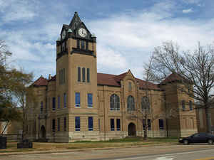
Autauga County is a county in the state of Alabama. Based on the 2010 census, the population was 54,571. The county seat is Prattville. Autauga County was created on November 21, 1818 from Montgomery County; by Act of December 13, 1820 the boundaries in the north and northwest were enlarged; on January 12, 1827 the line between Autauga County and Shelby County was more definitely fixed. In 1866 part of its territory was taken to establish Elmore County. In 1868 another portion of the county was taken to establish Baker County, later known as Chilton County. The county was named originated from the Indian village Atagi.
Autauga County is part of the Montgomery Metropolitan Statistical Area.
Etymology - Origin of Autauga County Name
The word "Autauga" comes from the Indian village Atagi, located on the Alabama River at the mouth of Autauga Creek. The meaning of the name Autauga is lost to history. Several interpretations range from "Clear Water" to "Land of Plenty."
Demographics:
County QuickFacts: Census Bureau Quick Facts
Autauga County History
Autauga County, Alabama
Alabama Territorial Legislature act was acknowledged on November 21, 1818
for Autauga County. As recognized, the county included present-day Autauga County,
as well as Elmore County and Chilton County. At the time, Autauga Indians lived
here, primarily in a village named Atagi (meaning "pure water") located on the
banks of a creek by the same name (called "Pearl Water Creek" by settlers). Autaugas
were members of the Alibamu clan. They sent many warriors to defend against Andrew
Jackson's invasion in the Creek War. This county was part of the region ceded
by the Creeks in the Treaty of Fort Jackson in 1814. The first county seat was
at Jackson's Mill, but the court only met there long enough to select a stable
seat at Washington, built on the former site of Atagi in the southeast corner
of the county. In 1830 the county seat was moved to a more central location at
Kingston and the town of Washington dwindled until it was completely deserted
in the late 1830s.
Daniel Pratt arrived in Autauga County around 1833 and discovered the new town
of Prattville, north of Atagi on the fall line of Autauga Creek. His cotton gin
plant quickly became the largest company of gins in the world and the first major
industry in Alabama. It was at his plant, and with his monetary backing, that
the Prattville Dragoons, a fighting unit for the Confederacy was well thought-out
in anticipation of Civil War. Other units formed in Autauga County included the
Autauga Rifles (Autaugaville), The John Steele Guards (western Autauga Co.) and
the Varina Rifles (northern Autauga Co.). None of the fighting of the Civil War
reached Autauga County and Pratt was able to secure payment of debts from Northern
accounts soon after the war, lessening the disabling effects of the rebuilding
period in the county.
Charles Atwood, a former slave belonging to Daniel Pratt purchased a house in
the center of Prattville soon after emancipation and was one of the founding
investors in Pratt's South and North Railroad. The presence of such a prominent
African-American family owning land in an Alabama city as early as the 1860s
is extraordinary.
Geography: Land and Water
As reported by the Census Bureau, the county has a total area of 604 square miles (1,560 km2), of which 594 square miles (1,540 km2) is land and 10 square miles (26 km2) (1.7%) is water.
Autauga County lies in the central area of state, wholly within the East Gulf Coastal Plain physiographic section. The Alabama River runs along the southern boundary of the county and numerous creeks, such as the Little Mulberry, Autauga, and Swift, intersect the area.
Early Autauga County was a verdant area filled with abundant game and water. It was this plentiful water that first attracted Pratt, who harnessed the flow of Autauga Creek to supply a ready source of power to his various industrial enterprises
Neighboring Counties
Bordering counties are as follows:
- North: Chilton County
- East: Elmore County
- Southeast: Montgomery County
- South: Lowndes County
- Southwest: Dallas County
Places of interest
Autauga County is home to several parks, such as Wilderness Park, Cooters Pond Park, Pratt Park, Swift Creek Park, Newton Park, Spinners Park, Heritage Park, and Overlook Memorial Park
Education
The Autauga County School System is the county's public school system.
East Memorial Christian Academy is located in an unincorporated area of the county, near Prattville


Click Image to Enlarge
