


Alabama Geography: The Land
Geography and Landforms of Alabama
Find an overview of Alabama geography, topography, geographic land regions, land areas, and major rivers.
Access Alabama almanac, furnishing more details on the state geography, geographical and land regions, climate and weather, elevation, land areas, bordering states, and other statistical data.
Alabama is a geographically diverse state, a fact seen while traveling from the mountains of the north to the coastal areas of the south. Numerous cities dot the landscape, adding to the geographic variety. Daily life in Alabama is affected by its geographical features, both natural and manufactured developments.
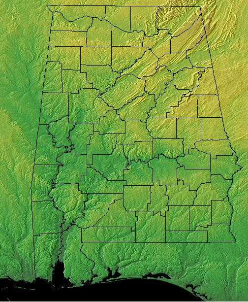
Alabama is comprised of coastal plains at the Gulf of Mexico sloping into hills and broken terrain in the north. Two thirds of the state are covered by the East Gulf Coastal Plain, including swamps. Above the coastal plain is the Appalachian Piedmont. Swamps, bayous and the like, along with nice, white-sand beaches are found in the southern reaches of the state. The highest point in Alabama is Cheaha Mountain at 2,407 feet, near Lineville. Major rivers include the Tombigbee, the Alabama, the Tennessee and the Chattahoochee. Russell Cave National Monument, near Bridgeport, is the site of caves that were inhabited continuously from 6000 BC to AD 1650.
Except for the mountainous section in the northeast (the southern end of the Cumberland Plateau) Alabama is a rolling plain with an average elevation of c.500 feet.
Alabama Highest, Lowest, & Mean Elevations |
|
|---|---|
| Mean Elevation | 500 ft. |
| Highest Point | Cheaha Mountain in the Talladega National Forest 2,405 ft. |
| Lowest Point | Gulf of Mexico Sea level |
Alabama Land Area (Square Miles) |
|
| Geographic Center | In Chilton Co., 12 mi. SW of Clanton Latitude: 32? 50.5'N Longitude: 86? 38.0'W |
| Area | 52,419.02 sq. mi. 30th |
| Land Area | 50,744.00 sq. mi. [Alabama is the 30th biggest state in the USA] 96.81% |
| Water Area | 1,675.01 sq. mi 3.19% |
| Forested Land Area | 67.6% |
| Dimensions (Length - Width) |
330 miles - 190 miles |
Alabama Physiographic Regions
In
the north and northeastern regions of Alabama, and along much of its border with Georgia, the lands are hilly and mountainous.
The central, west and southwestern areas are covered by rolling grassland plains that slope gently west into Mississippi, and south to the Gulf of
Mexico.
Five major land areas make up the Alabama landscape with more than two thirds of the state covered by the East Gulf Coastal Plain.
According to Sapp and Emplaincourt, these five physiographic sections in Alabama, three belonging to the Appalachian Highlands Region, and one each to the Inland Plains and the Atlantic Plain Regions
Piedmont Upland Section
(Piedmont Province)
{Appalachian Highlands Region}
The Southern Piedmont extends through central North Carolina, South Carolina, and Georgia and into eastern Alabama. The area is characterized by irregular plains and open hills with occasional tablelands. Elevations generally range from about 30 meters to 100 meters, but rise to about 400 meters at the interface with the Southern Blue Ridge. Numerous and diverse rivers comprise a major feature of the landscape. Although the Piedmont is geologically part of Southern Appalachia, the types of vegetation that characterize the region encompass a broad transition from upland forest types to the coastal plain. By most accounts, Piedmont forests were dominated by hardwoods at the time of early European settlement, and the extent far exceeded what exists today. However, the Piedmont was by no means entirely forested prior to European settlement. Eastern grasslands and savannas were extensive and present as late as the 1700's. Because Native American settlements were apparently common in the Piedmont, agricultural fields and other larger openings were historically part of the landscape.
Potential natural forest vegetation in the Southern Piedmont is oak-hickory-pine and Southern mixed forests. Southern red, northern red, chestnut, white, post and black are the most prevalent oaks. Shagbark, pignut, and mockernut are common hickory species. Shortleaf and loblolly are dominant pine species, with scattered longleaf stands along the Fall Line with the Coastal Plain. Pines are most prevalent on disturbed sites and due to the widespread historical disturbance factor, pines have replaced oaks and hickories in many cases.
A little bit of the Appalachian Piedmont creeps into the east-central portion of Alabama. The Appalachian Piedmont above the fall line and the coastal plain below. These plains, drained by the Alabama and the Tombigbee rivers and their tributaries, are primarily agriculture. Montgomery is the capital and Birmingham the largest city of Alabama. Mobile is the state's major seaport. Russell Cave National Monument, near Bridgeport, the site of caves that were inhabited almost continuously from 6000 BC to AD 1650, and Mound State Monument, near Tuscaloosa, the site of numerous early Native American mounds.
Tennessee Valley and Ridge Section
(Valley and Ridge Province)
{Appalachian Highlands Region}
This physiographic area consists of both the Southern end of the Ridge and Valley system as well as the tablelands of the Southern Cumberland Plateau. It descends to the Coastal Plain to the south and rises to the Blue Ridge to the east. It is located in eastern Tennessee, northwest Georgia, and northeast Alabama, and is arbitrarily separated from the Mid-Atlantic Ridge and Valley at the Tennessee-Virginia border. Upland deciduous forest, the most common naturally-occurring cover type, is predominantly mixed mesophytic, oak-hickory, or oak-pine forest. There is also a considerable area dominated by pine, either shortleaf or loblolly.
Northwest of the Piedmont lies the Appalachian Ridge and Valley region of Alabama. This region is comprised of sandstone ridges and fertile limestone valleys. The three ingredients for steel manufacture, coal, iron ore, and limestone are found in abundance in this area.
Cumberland Plateau Section
(Appalachian Plateaus Province)
{Appalachian Highlands Region}
This is a largely forested, gently rolling tableland ranging from 300 m. To 580 m. in elevation. It is defined by the higher Eastern Highland Rim of the Interior Low Plateaus on the west and the Cumberland Mountains of the Ridge and Valley physiographic area on the east. The Cumberland Plateau extends south out of this physiographic area, where it is included with the Southern Ridge and Valley, and narrowly northward as well. As defined, the Northern Cumberland Plateau includes the eastern third of Kentucky, southwestern West Virginia, a small area in western Virginia, and a swath across Tennessee barely extending into Alabama and Georgia. Mixed mesophytic forest dominated by oaks, hickory, and, historically, American chestnut, is the most common cover type. Various pine species become more dominant on drier sites.
Sometimes called the Appalachian Plateau, the Cumberland Plateau lies to the northwest of the Appalachian Ridge and Valley region. This is a largely forested, gently rolling tableland ranging from 300 m. To 580 m. in elevation.
East Gulf Coastal Plain
(Coastal Plain Province)
{Atlantic Plain Region }
;The East Gulf Coastal Plain extends from the Florida Parishes of Louisiana over most of Mississippi, some of western Tennessee and Kentucky, the southwestern 2/3 of Alabama, and the western panhandle of Florida. Its southern boundary is the Gulf of Mexico and its western boundary the drop into the Mississippi Alluvial Valley. On the north it extends to the highlands of the Interior Low Plateaus and southern Appalachians. To the east, there is an arbitrary break with the South Atlantic Coastal Plain at the Alabama-Georgia border south through Florida along the Apalachicola River. The flat to rolling topography is broken by numerous streams and river bottoms. Uplands are dominated by pine, originally longleaf and slash in the south and shortleaf mixed with hardwoods in the north. These are fire-maintained systems that give way to loblolly pine and hardwoods in damper areas and bottomland hardwood forest in extensive lowland drainages.
The East Gulf Coastal Plain covers the southern two thirds of Alabama, except for the Prairie Black Belt. But more on that later. On the western side of the state the East Gulf Coastal Plain runs north almost to the Tennessee border.
The East Gulf Coastal Plain itself is composed of varying landscapes. In the southwest around Mobile, the land is low and swampy. The southeast plain is called the wiregrass section because of the tough grass that once grew there among the pine forests. These days, the southeastern section has become an important farming area in the state. To the north, the terrain becomes hilly and is covered by many pine forests. This area is often called the Central Pine Belt.
The Black Belt Prairie cuts a path between the southern and northern East Coastal Plain. The Black Belt Prairie was the home of many of Alabama's large plantations. The soil in this swath of rolling hills is black and sticky and supported acres and acres of cotton crop until the boll weevils visit in 1915.
Highland Rim Section
(Interior Low Plateaus Province )
{Interior Plain Region}
The Interior Low Plateaus constitute a diverse landscape that extends from north Alabama across central Tennessee and Kentucky into southern Illinois, Indiana, and Ohio. It consists of six distinct subregions: the Shawnee Hills, Bluegrass region, Western Highland Rim, Central Basin, Eastern Highland Rim, and Tennessee Valley. Its hilly topography sets it apart from the Coastal Plain to the south and Prairie Peninsula to the north. To the west, the valley of the Mississippi River separates the Interior Low Plateaus from the Ozark Highlands, the two of which share many similarities. Western mesophytic, oak-hickory, and beech-maple forests were historically the most abundant cover types. There were also tallgrass prairie elements in the north and northwest, oak savannahs in the Bluegrass and other northern sections, barrens and glades in central regions, and forested wetlands along major waterways
In the northwestern corner of Alabama is the Highland Rim or Low Interior Plateau. A lot of this land is in the Tennessee River valley and farms grow corn, cotton, and hay in this area.

