


Click Image to Enlarge
Alabama Counties
Alabama currently has sixty-seven counties. The oldest county, Washington, was created on June 4, 1800, when what is now Alabama was then part of the Mississippi Territory. The newest county is Houston, created on February 9, 1903.Bibb County, Alabama History
Bibb County Education, Geography, and History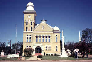
Bibb County is a county in the state of Alabama. As of the 23rd Decennial 2010 United States Census its population was 22,915. Bibb County (originally called Cahawba County, name was changed to Bibb on December 4, 1820) was created on Feb. 7, 1818 by the Alabama Territorial Legislature and was formed from Monroe County and Montgomery County. Alterations were made to the boundaries in 1818, 1819, 1820, 1821 and 1868. The county seat is Centreville. The county is named is in honor of William W. Bibb, (1781-1820), the Governor of Alabama Territory, (1817-1819).
It is a "prohibition" or
dry county, however, the cities of West Blocton, Brent, and Centreville have all become "wet", by allowing the sale of alcoholic beverages.
The Bibb County Courthouse is located in the county seat of Centreville, Alabama.
Etymology - Origin of Bibb County Name
State Legislature renamed it in honor of the late Governor William Wyatt Bibb, the Governor of Alabama Territory, (1817-1819) and the first Governor of Alabama, (1819-1820, when he died), who is also the namesake for Bibb County, Georgia where he began his political career.
Demographics:
County QuickFacts: CensusBureau Quick Facts
Bibb County History
Bibb County, Alabama
Bibb County was created by the Alabama Territorial Legislature on February 7, 1818. It was one of the first thirteen counties to be added to the seven already existing when Alabama was still a part of the Mississippi Territory. Originally, it was called Cahaba (spelled Cahawba for many years) to preserve the name given it by the Choctaw Indians, Oka Aba. On December 4, 1820, the State Legislature renamed it in honor of the late Governor William Wyatt Bibb. As it was then constituted, it contained much of what is now the southern part of Shelby County and the western part of Chilton County. Its present area is 625 square miles.
Many things have come and gone in the history of Bibb County. The Creeks and Choctaws came, and for long, years the separating line between their nations traversed the region. Their claims were ceded to the United States around 1814 to 1816, respectively, and a few years later they departed forever. White men came, early in the Nineteenth century, and started the farming processes which were destined to many supplements but never to departure. A group of Andrew Jackson's armed forces led by Major Mahan, came after the Battle of New Orleans, and settled the town of Brierfield, living first in tents and then in log homes on the site of a one-time Indian village. Among this military was John Clabaugh, great grandfather of President Sam Clabaugh of the Protective Life Insurance Company. He established a Camp on Branch Creek near the present town of Centerville. A little later there came from South Carolina another man who was also a great
grandfather of President Clabaugh. This was Jonathan Ware, who had constructed Cowpens, S. C., on the site of the famous Revolutionary battlefield there, a forge to assemble one of the first irons in that state. In Bibb County he constructed a Catalan forge, and launched the region on its first primitive iron manufacture. Jonathan Ware and his son Horace were later termed by Senator Morgan "chief of the early iron masters of Alabama." Associated with them was Samuel Clabaugh, the son of John Clabaugh.
Around the 1830's until the War Between the States, the three counties of Bibb, Shelby and Talladega were the most active in the state in the making of iron blooms. An iron furnace was constructed at Brierfield by Major Mahan and his son, Edward, won first prize with its charcoal iron blooms at a British exhibition in 1851.
Around 1860 the Brierfield mines, furnace and rolling mill were taken over by the Confederate government (under a forced sale,) and they were important sources of land and naval guns until Federal troops under General Wilson ruined them around 1865. The land was sold at public sale after the war to Francis Strother Lyon, who rebuilt it with the aid of Gen. Josiah Gorgas, Confederate chief of ordnance. In full blast again by 1868, the plant survived a change of hands in the panic of 1873 and was important for a while in the manufacture of nails but became finally a victim of superior processes and ore discoveries and was dismantled forever in the '80's. With its passing Brierfield which had become the important industrial center of the whole of central Alabama, dropped out of the economic picture. The charred shells of old factories and iron Foundries stand there today in romantic reminder of great days gone by.
Geography: Land and Water
As reported by the Census Bureau, the county has a total area of 626 square miles (1,620 km2), of which 623 square miles (1,610 km2) is land and 3.6 square miles (9.3 km2) (0.6%) is water.
The Cahaba River runs through Bibb County from north to south, and
its tributaries, the Little Cahaba, Sixmile Creek, and Shultz Creek,
flow through the eastern and western parts of the county. Numerous other
creeks intersect its southwestern region.
Neighboring Counties:
- Northeast: Jefferson County; Shelby County
- Southeast: Chilton County
- Southwest: Perry County; Hale County
- Northwest: Tuscaloosa County
Places of interest
Bibb County is home to the Talladega National Forest supervised by the United States Forestry Service (of the US Department of Agriculture), and a section of the Cahaba River which draws visitors to view the unique "Cahaba Lily", or (known by its scientific Latinized name: Hymenocallis coronaria).
Education


Click Image to Enlarge
